Pryor Brock Farmstead
|
Brock, Pryor Farmstead | |
|
Buildings on the farmstead | |
   | |
| Location | 8602 E500S, Zionsville, Indiana |
|---|---|
| Coordinates | 39°58′13″N 86°18′22″W / 39.97028°N 86.30611°WCoordinates: 39°58′13″N 86°18′22″W / 39.97028°N 86.30611°W |
| Area | 4.9 acres (2.0 ha) |
| Architectural style | Italianate |
| MPS | Eagle Township and Pike Township, Indiana MPS |
| NRHP Reference # | 08000569[1] |
| Added to NRHP | June 27, 2008 |
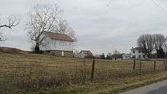
The Pryor Brock Farmstead is a place on the National Register of Historic Places just west of Zionsville, Indiana, comprising 4.9 acres (20,000 m2) of what was once a 200-acre (0.81 km2) farm. It was placed on the Register, June 27, 2008, due to its role in the agricultural history of Eagle Township, Boone County, Indiana. Pryor Brock Farmstead, with its carpenter's rendering of Italianate architecture, is the best representation of the prosperous agricultural setting around Zionsville/Eagle Township during its time of significance (1870-1920), the "golden age" of Hoosier agriculture.[2]
The farm was built by Pryor and Emeline Brock. Pryor was born on January 31, 1823 in Tennessee, and moved to Putnam County, Indiana in 1829 when his father Allen Brock chose to relocate; the family removed to Boone County in 1832. Pryor married Emeline Stoneking in 1846. It was in 1878 that the Brocks built the house, after some of their older children had already moved out. By 1880 the value of the land was $10,000 when the county average was $1,180. Emeline died in 1884, with Pryor eventually marrying an Emma Lemon when he was 68 years old. Pryor would be 75 years old when he died on October 3, 1898. The farmstead continued in the Brock family until 2006, when Rosemary Brock Rudwolis died, with a codicil stating the structures on the property should be maintained and preserved.[2]
The wood-framed main house is a Late Victorian-Italianate structure, with a stone foundation, wood/clapboard walls, and an asphalt roof. Although well made, the Brock's purposely avoided "urban showiness". The farmland is one of the few elevated areas of an otherwise flat, featureless countryside. Partially covered boulders which came to the area as glacial erratics flank the entrance to the property.[2]
References
- ↑ National Park Service (2010-07-09). "National Register Information System". National Register of Historic Places. National Park Service.
- 1 2 3 "Indiana State Historic Architectural and Archaeological Research Database (SHAARD)" (Searchable database). Department of Natural Resources, Division of Historic Preservation and Archaeology. Retrieved 2015-07-01. Note: This includes Connie Ziegler (March 2007). "National Register of Historic Places Inventory Nomination Form: Pryor Brock Farmstead" (PDF). Retrieved 2015-07-01. and Accompanying photographs.

