Prairie du Sac, Wisconsin
| Prairie du Sac, Wisconsin | |
|---|---|
| Village | |
|
Downtown Prairie du Sac | |
 Location of Prairie du Sac, Wisconsin | |
| Coordinates: 43°16′44″N 89°47′16″W / 43.27889°N 89.78778°WCoordinates: 43°16′44″N 89°47′16″W / 43.27889°N 89.78778°W | |
| Country | United States |
| State | Wisconsin |
| County | Sauk |
| Area[1] | |
| • Total | 1.66 sq mi (4.30 km2) |
| • Land | 1.55 sq mi (4.01 km2) |
| • Water | 0.11 sq mi (0.28 km2) |
| Elevation[2] | 768 ft (234 m) |
| Population (2010)[3] | |
| • Total | 3,972 |
| • Estimate (2012[4]) | 4,112 |
| • Density | 2,562.6/sq mi (989.4/km2) |
| Time zone | Central (CST) (UTC-6) |
| • Summer (DST) | CDT (UTC-5) |
| Area code(s) | 608 |
| FIPS code | 55-65125[5] |
| GNIS feature ID | 1583974[2] |
| Website | http://www.prairiedusac.net |

Prairie du Sac is a village in Sauk County, Wisconsin, United States. The population was 3,972 at the 2010 census. The village is surrounded by the Town of Prairie du Sac, the Wisconsin River, and the village of Sauk City; together, Prairie du Sac and Sauk City are referred to as Sauk Prairie.
History
Prairie du Sac was so named because it was in the large Wisconsin River Valley where the Sauk Indians had a large settlement.[6] Although the name of the village dates from the early days of French fur traders, Prairie du Sac was established as a village by D.B. Crocker in 1840, largely as a Yankee-English village,[7] in contrast to its neighbor, Sauk City, which was settled largely by Germans.
Geography
Prairie du Sac is located at 43°17′23″N 89°43′42″W / 43.28972°N 89.72833°W (43.289833, -89.728524).[8]
According to the United States Census Bureau, the village has a total area of 1.66 square miles (4.30 km2), of which, 1.55 square miles (4.01 km2) of it is land and 0.11 square miles (0.28 km2) is water.[1]
Airport
Prairie du Sac is serviced by the Sauk-Prairie Airport (91C).
Demographics
| Historical population | |||
|---|---|---|---|
| Census | Pop. | %± | |
| 1880 | 433 | — | |
| 1890 | 562 | 29.8% | |
| 1900 | 656 | 16.7% | |
| 1910 | 699 | 6.6% | |
| 1920 | 866 | 23.9% | |
| 1930 | 949 | 9.6% | |
| 1940 | 1,001 | 5.5% | |
| 1950 | 1,402 | 40.1% | |
| 1960 | 1,676 | 19.5% | |
| 1970 | 1,902 | 13.5% | |
| 1980 | 2,145 | 12.8% | |
| 1990 | 2,380 | 11.0% | |
| 2000 | 3,231 | 35.8% | |
| 2010 | 3,972 | 22.9% | |
| Est. 2015 | 4,255 | [9] | 7.1% |
2010 census
As of the census[3] of 2010, there were 3,972 people, 1,649 households, and 1,075 families residing in the village. The population density was 2,562.6 inhabitants per square mile (989.4/km2). There were 1,733 housing units at an average density of 1,118.1 per square mile (431.7/km2). The racial makeup of the village was 94.3% White, 0.6% African American, 0.3% Native American, 0.6% Asian, 2.7% from other races, and 1.5% from two or more races. Hispanic or Latino of any race were 4.8% of the population.
There were 1,649 households of which 35.1% had children under the age of 18 living with them, 50.6% were married couples living together, 10.6% had a female householder with no husband present, 3.9% had a male householder with no wife present, and 34.8% were non-families. 28.6% of all households were made up of individuals and 12.8% had someone living alone who was 65 years of age or older. The average household size was 2.41 and the average family size was 2.96.
The median age in the village was 36.2 years. 25.8% of residents were under the age of 18; 7.2% were between the ages of 18 and 24; 29.5% were from 25 to 44; 24.5% were from 45 to 64; and 13% were 65 years of age or older. The gender makeup of the village was 48.4% male and 51.6% female.
2000 census
As of the census[5] of 2000, there were 3,231 people, 1,290 households, and 869 families residing in the village. The population density was 2,450.9 people per square mile (945.1/km²). There were 1,332 housing units at an average density of 1,010.4 per square mile (389.6/km²). The racial makeup of the village was 98.14% White, 0.12% Black or African American, 0.22% Native American, 0.31% Asian, 0.46% from other races, and 0.74% from two or more races. 2.04% of the population were Hispanic or Latino of any race.
There were 1,290 households out of which 34.3% had children under the age of 18 living with them, 54.8% were married couples living together, 8.7% had a female householder with no husband present, and 32.6% were non-families. 25.5% of all households were made up of individuals and 10.6% had someone living alone who was 65 years of age or older. The average household size was 2.50 and the average family size was 3.04.
In the village the population was spread out with 27.8% under the age of 18, 7.8% from 18 to 24, 32.1% from 25 to 44, 19.9% from 45 to 64, and 12.5% who were 65 years of age or older. The median age was 35 years. For every 100 females there were 96.2 males. For every 100 females age 18 and over, there were 92.3 males.
The median income for a household in the village was $44,472, and the median income for a family was $55,234. Males had a median income of $35,020 versus $28,882 for females. The per capita income for the village was $23,068. About 4.7% of families and 7.4% of the population were below the poverty line, including 13.3% of those under age 18 and 3.9% of those age 65 or over.
Sauk Prairie
Sauk City is adjacent to Prairie du Sac, directly to the south. Both communities are located on the west bank of the Wisconsin River. They share a municipal boundary, as well as schools, a police department and a hospital, but have separate fire departments and libraries. Efforts have been made to join the two villages into a single entity, Sauk Prairie, but these have failed.
Economy
The corporate headquarters of Culver's Franchising Systems, Inc. is located in Prairie du Sac. The first Culver's opened in the adjacent city of Sauk City, July 18, 1984. The corporate headquarters of Badgerland Financial and Mueller Sports Medicine are also in Prairie du Sac. Milwaukee Valve has a factory there.
Media
- Voice of the River Valley magazine, a guide to people and events that inspire, inform and enrich life in the Lower Wisconsin and Sugar-Pecatonica River Basins
Notable residents
- Peter A. Hemmy, Wisconsin State Assemblyman
- George DeGraw Moore, Wisconsin State Senator and New Jersey jurist
- J. B. Ragatz, Wisconsin State Assemblyman
- Scott Schutt, former Cincinnati Bengals player
Images
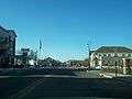 Looking north at downtown Prairie du Sac
 Looking north at downtown Prairie du Sac
See also
References
- 1 2 "US Gazetteer files 2010". United States Census Bureau. Retrieved 2012-11-18.
- 1 2 "US Board on Geographic Names". United States Geological Survey. 2007-10-25. Retrieved 2008-01-31.
- 1 2 "American FactFinder". United States Census Bureau. Retrieved 2012-11-18.
- ↑ "Population Estimates". United States Census Bureau. Retrieved 2013-06-24.
- 1 2 "American FactFinder". United States Census Bureau. Retrieved 2008-01-31.
- ↑ Cole, Harry Ellsworth (1918). A Standard History of Sauk County, Wisconsin. Lewis Publishing Company. p. 415.
- ↑ "Prairie du Sac, Sauk Co. (origin of place name)". Dictionary of Wisconsin History.
- ↑ "US Gazetteer files: 2010, 2000, and 1990". United States Census Bureau. 2011-02-12. Retrieved 2011-04-23.
- ↑ "Annual Estimates of the Resident Population for Incorporated Places: April 1, 2010 to July 1, 2015". Retrieved July 2, 2016.
- ↑ "Census of Population and Housing". Census.gov. Retrieved June 4, 2015.
External links
| Wikimedia Commons has media related to Prairie du Sac, Wisconsin. |
- Village of Prairie du Sac
- Sauk Prairie Chamber of Commerce
- Sauk Prairie Area Historical Society
- Sauk Prairie website
- Prairie du Sac Library
- Germans in the Sauk Prairie Area
Municipalities and communities of Sauk County, Wisconsin, United States | ||
|---|---|---|
| Cities | 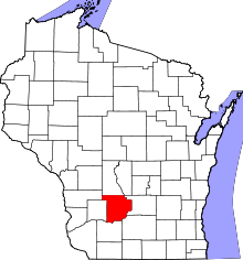 | |
| Villages | ||
| Towns | ||
| CDPs | ||
| Unincorporated communities | ||
| Indian reservation | ||
| Footnotes | ‡This populated place also has portions in an adjacent county or counties | |