Ponce de Leon, Missouri
| Ponce de Leon | |
|---|---|
| unincorporated community | |
 Ponce de Leon Location within Missouri | |
| Coordinates: 36°52′34″N 93°21′4″W / 36.87611°N 93.35111°WCoordinates: 36°52′34″N 93°21′4″W / 36.87611°N 93.35111°W | |
| Country | United States |
| State | Missouri |
| County | Stone County |
| Founded | about 1875 |
Ponce de Leon is an unincorporated community in northeastern Stone County, Missouri, United States, about 30 miles (50 km) south of Springfield. It is part of the Branson, Missouri Micropolitan Statistical Area.
The community is located on the East Prong Goff Creek which is a tributary of the James River about three miles to the west. Missouri Supplemental Route V passes through the village which lies at an elevation of 1100 feet. Spokane in Christian County lies about three miles to the east on US Route 160. Branson lies about 25 miles to the south.[1]
History
The community was founded about 1875 as a health resort to exploit the mineral spring at the location. The resort was named for the explorer Juan Ponce de León.[2]
The resort and town prospered and with a population of around 1000 it was the largest town in the county. Businesses included a sawmill, a gristmill, a bank and tomato cannery. However, the boom didn't last and by 1885 damage by flash floods and other economic problems led to decay and loss of population.[2]
Area residents refer to the community as "Poncie"; for years, use of the full name has virtually been abandoned.
References
- ↑ Highlandville, Missouri, (1955) and Spokane, Missouri, (1956) 7.5 Minute Topographic Quadrangles, USGS
- 1 2 A Directory of Towns, Villages and Hamlets of Stone County, Missouri Compiled by Author Paui Moser, White River Valley Historical Quarterly, Volume 4, Number 6 - Winter 1971
Municipalities and communities of Stone County, Missouri, United States | ||
|---|---|---|
| Cities | 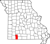 | |
| Villages | ||
| CDP | ||
| Unincorporated communities | ||
| Footnotes | ‡This populated place also has portions in an adjacent county or counties | |