Point Neighborhood Historic District
|
Point Neighborhood Historic District | |
|
Congress Street scene | |
  | |
| Location | Salem, Massachusetts |
|---|---|
| Coordinates | 42°31′0″N 70°53′29″W / 42.51667°N 70.89139°WCoordinates: 42°31′0″N 70°53′29″W / 42.51667°N 70.89139°W |
| NRHP Reference # | 14000972[1] |
| Added to NRHP | December 2, 2014 |
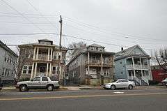
The Point Neighborhood Historic District, also known as Stage Point, is a predominantly residential historic district just south of downtown Salem, Massachusetts. It is a densely built, roughly rectangular grid of streets east of Lafayette Street, south of the South River, west of Congress Street, and north of Chase and Leavitt Streets. This area was the target of a major redevelopment effort undertaken by the city after a fire swept through it in 1914. With many multiunit residential buildings constructed in just three years, the architecture of the area is remarkably cohesive. Commercial development is generally restricted to the fringes of the area, on Lafayette Street (a major local thoroughfare) and Congress Street.[2]
The district was listed on the National Register of Historic Places in 2014.[1]
See also
| Wikimedia Commons has media related to Point Neighborhood Historic District. |
- National Register of Historic Places listings in Salem, Massachusetts
- National Register of Historic Places listings in Essex County, Massachusetts
References
- 1 2 National Park Service (2008-04-15). "National Register Information System". National Register of Historic Places. National Park Service.
- ↑ "MACRIS inventory record for Point Neighborhood". Commonwealth of Massachusetts. Retrieved 2014-12-15.
| Topics |  | ||||||||||||||||||||||||||||||
|---|---|---|---|---|---|---|---|---|---|---|---|---|---|---|---|---|---|---|---|---|---|---|---|---|---|---|---|---|---|---|---|
| Lists by county | |||||||||||||||||||||||||||||||
| Lists by city |
| ||||||||||||||||||||||||||||||
| Other lists | |||||||||||||||||||||||||||||||
| |||||||||||||||||||||||||||||||