Plan-d'Aups-Sainte-Baume
| Plan-d'Aups-Sainte-Baume | ||
|---|---|---|
|
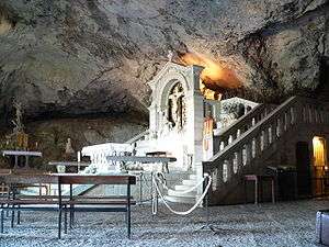
The cave of Sainte-Baume | ||
| ||
 Plan-d'Aups-Sainte-Baume | ||
|
Location within Provence-A.-C.d'A. region  Plan-d'Aups-Sainte-Baume | ||
| Coordinates: 43°19′46″N 5°43′01″E / 43.3295°N 5.717°ECoordinates: 43°19′46″N 5°43′01″E / 43.3295°N 5.717°E | ||
| Country | France | |
| Region | Provence-Alpes-Côte d'Azur | |
| Department | Var | |
| Arrondissement | Brignoles | |
| Canton | Saint-Maximin-la-Sainte-Baume | |
| Intercommunality | Sainte-Baume Mont-Aurélien | |
| Government | ||
| • Mayor (2001–2008) | Vincent Martinez | |
| Area1 | 24.91 km2 (9.62 sq mi) | |
| Population (2006)2 | 1,144 | |
| • Density | 46/km2 (120/sq mi) | |
| Time zone | CET (UTC+1) | |
| • Summer (DST) | CEST (UTC+2) | |
| INSEE/Postal code | 83093 / 83640 | |
| Elevation |
510–1,148 m (1,673–3,766 ft) (avg. 700 m or 2,300 ft) | |
|
1 French Land Register data, which excludes lakes, ponds, glaciers > 1 km² (0.386 sq mi or 247 acres) and river estuaries. 2 Population without double counting: residents of multiple communes (e.g., students and military personnel) only counted once. | ||
.svg.png)
Plan-d'Aups-Sainte-Baume is a commune in the Var department in the Provence-Alpes-Côte d'Azur region in southeastern France.
Second World War
In June 1944, at the aftermath of D-Day when the French Resistance went on an offensive against the German occupiers, the hills near Plan-d'Aups were the site of a bloody battle. Some 200 Maquis had set up a camp there, commanded by SOE agent Robert Burdett. They were attacked by large German forces. Though taken by surprise due to a faulty placing of guards, the Maquis did inflict considerable casualties on the Germans and many of them managed to escape into the surrounding mountains.[1]
See also
References
- ↑ Evelyn Le Chene, "Watch for Me by Moonlight" (wartime experiences of Robert Burdett), Corgi, London 1974
| Wikimedia Commons has media related to Plan-d'Aups-Sainte-Baume. |
This article is issued from Wikipedia - version of the 2/6/2015. The text is available under the Creative Commons Attribution/Share Alike but additional terms may apply for the media files.