Montauroux
| Montauroux | ||
|---|---|---|
| ||
 Montauroux | ||
|
Location within Provence-A.-C.d'A. region  Montauroux | ||
| Coordinates: 43°37′09″N 6°45′57″E / 43.6192°N 6.7658°ECoordinates: 43°37′09″N 6°45′57″E / 43.6192°N 6.7658°E | ||
| Country | France | |
| Region | Provence-Alpes-Côte d'Azur | |
| Department | Var | |
| Arrondissement | Draguignan | |
| Canton | Fayence | |
| Government | ||
| • Mayor (2014–2020) | Jean-Yves HUET | |
| Area1 | 33.41 km2 (12.90 sq mi) | |
| Population (2006)2 | 4,843 | |
| • Density | 140/km2 (380/sq mi) | |
| Time zone | CET (UTC+1) | |
| • Summer (DST) | CEST (UTC+2) | |
| INSEE/Postal code | 83081 / 83440 | |
| Elevation | 150–400 m (490–1,310 ft) | |
|
1 French Land Register data, which excludes lakes, ponds, glaciers > 1 km² (0.386 sq mi or 247 acres) and river estuaries. 2 Population without double counting: residents of multiple communes (e.g., students and military personnel) only counted once. | ||
.svg.png)
Montauroux is a commune in the Var department in the Provence-Alpes-Côte d'Azur region in southeastern France.
Its neighbor town is the picturesque Callian which can be seen across a small valley.
Geography
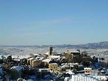
Montauroux is situated in the east of the Var and at the border of the Alpes-Maritimes. Montauroux rises in tiers of altitudes from 150 m to 400 m. The village has a southern exposure, facing the Esterel massif and the St Cassien Lake. Montauroux is located midway between the sea which is 30 km (19 mi) away and the first ski resort which is 40 km (25 mi), away. Montauroux benefits from an exceptional amount of sunny days and is visited by tourists in the summer months, many hotels are often fully booked for the summer by mid-April or earlier.
It is also part of the Pays de Fayence, a communauté de communes.
See also
References
| Wikimedia Commons has media related to Montauroux. |