Ramatuelle
| Ramatuelle | ||
|---|---|---|
|
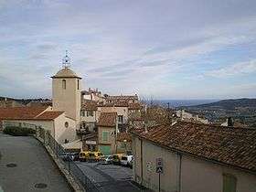
A general view of Ramatuelle | ||
| ||
 Ramatuelle | ||
|
Location within Provence-A.-C.d'A. region  Ramatuelle | ||
| Coordinates: 43°13′00″N 6°36′43″E / 43.2167°N 6.6119°ECoordinates: 43°13′00″N 6°36′43″E / 43.2167°N 6.6119°E | ||
| Country | France | |
| Region | Provence-Alpes-Côte d'Azur | |
| Department | Var | |
| Arrondissement | Draguignan | |
| Canton | Saint-Tropez | |
| Government | ||
| • Mayor (2001–2008) | Roland Bruno | |
| Area1 | 35.57 km2 (13.73 sq mi) | |
| Population (2006)2 | 2,326 | |
| • Density | 65/km2 (170/sq mi) | |
| Time zone | CET (UTC+1) | |
| • Summer (DST) | CEST (UTC+2) | |
| INSEE/Postal code | 83101 / 83350 | |
| Elevation |
0–324 m (0–1,063 ft) (avg. 146 m or 479 ft) | |
|
1 French Land Register data, which excludes lakes, ponds, glaciers > 1 km² (0.386 sq mi or 247 acres) and river estuaries. 2 Population without double counting: residents of multiple communes (e.g., students and military personnel) only counted once. | ||

.svg.png)
Ramatuelle is a commune in the Var department in the Provence-Alpes-Côte d'Azur region in southeastern France.
It lies near St-Tropez, Sainte-Maxime and Gassin. It was built on a hill to defend itself against enemies. The town was known in the Middle Ages as Ramatuella (derived from the Arabic Rahmatollah i.e. 'the mercy of God')[1] and was part of the area ruled by the Moors of nearby Fraxinet in the ninth and tenth centuries.[2]
Detail of Street
See also
References
- ↑ Xavier de Planhol; Paul Claval (1994). An Historical Geography of France (illustrated ed.). Cambridge University Press. p. 84. ISBN 9780521322089.
- ↑ P. Sénac, "Contribution a l'étude des incursions Musulmanes dans l'Occident Chrétien: la localisation du Ğabal al-Qilāl" Revue de l'Occident Musulman et de la Méditerranée, 31 (1981) 7–14
External links
| Wikimedia Commons has media related to Ramatuelle. |
This article is issued from Wikipedia - version of the 5/1/2016. The text is available under the Creative Commons Attribution/Share Alike but additional terms may apply for the media files.