Pierce County, Wisconsin
| Pierce County, Wisconsin | |
|---|---|
 Pierce County Courthouse | |
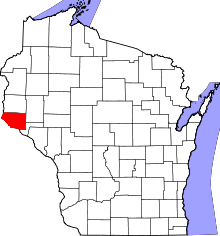 Location in the U.S. state of Wisconsin | |
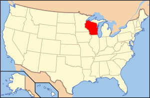 Wisconsin's location in the U.S. | |
| Founded | 1853 |
| Named for | Franklin Pierce[1] |
| Seat | Ellsworth |
| Largest city | River Falls |
| Area | |
| • Total | 592 sq mi (1,533 km2) |
| • Land | 574 sq mi (1,487 km2) |
| • Water | 18 sq mi (47 km2), 3.1% |
| Population | |
| • (2010) | 41,019 |
| • Density | 71/sq mi (27/km²) |
| Congressional district | 3rd |
| Time zone | Central: UTC-6/-5 |
| Website |
www |
Pierce County is a county located in the U.S. state of Wisconsin. As of the 2010 census, the population was 41,019.[2] Its county seat is Ellsworth.[3]
Pierce County is part of the Minneapolis–St. Paul–Bloomington, MN-WI Metropolitan Statistical Area.
Geography
According to the U.S. Census Bureau, the county has a total area of 592 square miles (1,530 km2), of which 574 square miles (1,490 km2) is land and 18 square miles (47 km2) (3.1%) is water.[4]
Adjacent counties
- St. Croix County – north
- Dunn County – northeast
- Pepin County – southeast
- Goodhue County, Minnesota – south
- Dakota County, Minnesota – southwest
- Washington County, Minnesota – west
National protected area
Demographics

| Historical population | |||
|---|---|---|---|
| Census | Pop. | %± | |
| 1860 | 4,672 | — | |
| 1870 | 9,958 | 113.1% | |
| 1880 | 17,744 | 78.2% | |
| 1890 | 20,385 | 14.9% | |
| 1900 | 23,943 | 17.5% | |
| 1910 | 22,079 | −7.8% | |
| 1920 | 21,663 | −1.9% | |
| 1930 | 21,043 | −2.9% | |
| 1940 | 21,471 | 2.0% | |
| 1950 | 21,448 | −0.1% | |
| 1960 | 22,503 | 4.9% | |
| 1970 | 26,652 | 18.4% | |
| 1980 | 31,149 | 16.9% | |
| 1990 | 32,765 | 5.2% | |
| 2000 | 36,804 | 12.3% | |
| 2010 | 41,019 | 11.5% | |
| Est. 2015 | 40,889 | [5] | −0.3% |
| U.S. Decennial Census[6] 1790–1960[7] 1900–1990[8] 1990–2000[9] 2010–2014[2] | |||
As of the census[10] of 2000, there were 36,804 people, 13,015 households, and 9,032 families residing in the county. The population density was 64 people per square mile (25/km²). There were 13,493 housing units at an average density of 23 per square mile (9/km²). The racial makeup of the county was 98.01% White, 0.25% Black or African American, 0.29% Native American, 0.43% Asian, 0.03% Pacific Islander, 0.28% from other races, and 0.72% from two or more races. 0.82% of the population were Hispanic or Latino of any race. 41.0% were of German, 16.2% Norwegian, 7.1% Swedish and 7.1% Irish ancestry according to Census 2000.
There were 13,015 households out of which 35.00% had children under the age of 18 living with them, 58.10% were married couples living together, 7.50% had a female householder with no husband present, and 30.60% were non-families. 21.30% of all households were made up of individuals and 7.50% had someone living alone who was 65 years of age or older. The average household size was 2.65 and the average family size was 3.10.
In the county, the population was spread out with 24.40% under the age of 18, 17.00% from 18 to 24, 28.10% from 25 to 44, 20.80% from 45 to 64, and 9.60% who were 65 years of age or older. The median age was 32 years. For every 100 females there were 97.30 males. For every 100 females age 18 and over, there were 94.20 males.
Communities
Cities
- Prescott
- River Falls (partly in St. Croix County)
Villages
- Bay City
- Ellsworth (county seat)
- Elmwood
- Maiden Rock
- Plum City
- Spring Valley (partly in St. Croix County)
Towns
Census-designated places
Unincorporated communities
Ghost town
- Brasington
See also
References
- ↑ Chicago and North Western Railway Company (1908). A History of the Origin of the Place Names Connected with the Chicago & North Western and Chicago, St. Paul, Minneapolis & Omaha Railways. p. 163.
- 1 2 "State & County QuickFacts". United States Census Bureau. Retrieved January 23, 2014.
- ↑ "Find a County". National Association of Counties. Retrieved 2011-06-07.
- ↑ "2010 Census Gazetteer Files". United States Census Bureau. August 22, 2012. Retrieved August 8, 2015.
- ↑ "County Totals Dataset: Population, Population Change and Estimated Components of Population Change: April 1, 2010 to July 1, 2015". Retrieved July 2, 2016.
- ↑ "U.S. Decennial Census". United States Census Bureau. Retrieved August 8, 2015.
- ↑ "Historical Census Browser". University of Virginia Library. Retrieved August 8, 2015.
- ↑ Forstall, Richard L., ed. (March 27, 1995). "Population of Counties by Decennial Census: 1900 to 1990". United States Census Bureau. Retrieved August 8, 2015.
- ↑ "Census 2000 PHC-T-4. Ranking Tables for Counties: 1990 and 2000" (PDF). United States Census Bureau. April 2, 2001. Retrieved August 8, 2015.
- ↑ "American FactFinder". United States Census Bureau. Retrieved 2011-05-14.
Further reading
- Weld, Allen P. The Story of Pierce County. La Crosse, Wis.: Brookhaven Press.
External links
- Pierce County government website
- Pierce County map from the Wisconsin Department of Transportation
 |
St. Croix County | Dunn County | | |
| Washington County, Minnesota | |
|||
| ||||
| | ||||
| Dakota County, Minnesota | Goodhue County, Minnesota | Pepin County |
Municipalities and communities of Pierce County, Wisconsin, United States | ||
|---|---|---|
| Cities | | |
| Villages | ||
| Towns | ||
| CDPs | ||
| Unincorporated communities | ||
| Ghost town |
| |
| Footnotes | ‡This populated place also has portions in an adjacent county or counties | |
Coordinates: 44°43′N 92°25′W / 44.72°N 92.42°W