Phanom District
| Phanom พนม | |
|---|---|
| Amphoe | |
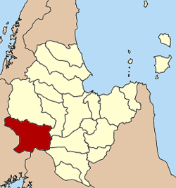 Amphoe location in Surat Thani Province | |
| Coordinates: 8°51′18″N 98°48′48″E / 8.85500°N 98.81333°ECoordinates: 8°51′18″N 98°48′48″E / 8.85500°N 98.81333°E | |
| Country |
|
| Province | Surat Thani |
| Seat | Phanom |
| Area | |
| • Total | 707.6 km2 (273.2 sq mi) |
| Population (2005) | |
| • Total | 33,513 |
| • Density | 47.4/km2 (123/sq mi) |
| Time zone | THA (UTC+7) |
| Postal code | 84250 |
| Geocode | 8410 |
Phanom (Thai: พนม) is a district (Amphoe) in the southwest of Surat Thani Province of southern Thailand.
Geography
The district is located within the hills of the Phuket mountain range, with around 60% of the area consisting of mountains and forests. The northwestern part of the district is protected in the Khao Sok national park, in the southwest the Khlong Phanom National Park. The district marks the eastern end of the pass through the mountains, connecting Takua Pa with Surat Thani. This historic pass along the Sok river valley is now the route of Thailand Route 401.
Neighboring districts are (from north clockwise) Ban Ta Khun, Khiri Rat Nikhom, Khian Sa and Phrasaeng of Surat Thani, Plai Phraya of Krabi Province, Thap Put, Mueang Phang Nga, Kapong, Takua Pa and Khura Buri of Phang Nga Province.
History

The district was created in 1890, at that time named Khlong Cha Un (คลองชะอุ่น). It was later renamed to Pak Phanom (ปากพนม), as the district office was moved to a new located at Phak Phanom, which was then shortened to simply Phanom. The first district officer was Khun Phanom Thana Rak. In 1910 the district was reduced to a minor district (king amphoe) and made a subordinate of Khirirat Nikhom district.[1] On November 14, 1971 it regained full district status.[2]
Symbols
The slogan of the district is Beautiful Rafflesia, rich in hills covered by mist.
Administration
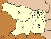
The district is subdivided into 6 subdistricts (tambon), which are further subdivided into 56 villages (muban). Phanom itself has a township (thesaban tambon) status and covers tambon Phang Kan and parts of tambon Phanom. Each of the 6 tambon is administrated by a Tambon administrative organization (TAO).
|
 |
References
- ↑ แจ้งความกระทรวงมหาดไทย เรื่อง ยุบอำเภอพนมแขวงเมืองไชยา ลงเป็นกิ่งอำเภอ ขึ้นอยู่ในอำเภอคิรีรัฐนิคม (PDF). Royal Gazette (in Thai). 27 (0 ง): 688. July 17, 1910.
- ↑ พระราชกฤษฎีกาตั้งอำเภอปลาปาก อำเภอเชียงกลาง อำเภอปากชม อำเภอบ้านม่วง อำเภอพังโคน อำเภอดอนสัก อำเภอพนม อำเภอเวียงสระ อำเภอสังคม และอำเภอหัวตะพาน พ.ศ. ๒๕๑๔ (PDF). Royal Gazette (in Thai). 88 (123 ก): 745–748. November 16, 1971.