Kapong District
| Kapong กะปง | |
|---|---|
| Amphoe | |
 Amphoe location in Phang Nga Province | |
| Coordinates: 8°41′48″N 98°24′30″E / 8.69667°N 98.40833°ECoordinates: 8°41′48″N 98°24′30″E / 8.69667°N 98.40833°E | |
| Country |
|
| Province | Phang Nga |
| Seat | Tha Na |
| Area | |
| • Total | 588.793 km2 (227.334 sq mi) |
| Population (2005) | |
| • Total | 12,963 |
| • Density | 22.0/km2 (57/sq mi) |
| Time zone | THA (UTC+7) |
| Postal code | 82170 |
| Geocode | 8203 |
Kapong (Thai: กะปง) is a district (amphoe) in the province Phang Nga in the south of Thailand.
Geography
Neighboring districts are (from the north clockwise) Phanom of Surat Thani Province, Mueang Phang Nga, Thai Mueang and Takua Pa.
The forests of the district are part of the Khao Lak-Lam Ru National Park.
Administration
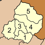
The district Kapong is subdivided into 5 subdistricts (tambon), which are further subdivided into 22 villages (muban). Tha Na has township (thesaban tambon) status and covers parts of the tambon Tha Na. There are four Tambon administrative organization (TAO), tambon Kapong is administrated by a neighboring tambon.
|
 |
External links
This article is issued from Wikipedia - version of the 8/6/2014. The text is available under the Creative Commons Attribution/Share Alike but additional terms may apply for the media files.