Don Sak District
| Don Sak ดอนสัก | |
|---|---|
| Amphoe | |
 Amphoe location in Surat Thani Province | |
| Coordinates: 9°18′50″N 99°41′25″E / 9.31389°N 99.69028°ECoordinates: 9°18′50″N 99°41′25″E / 9.31389°N 99.69028°E | |
| Country |
|
| Province | Surat Thani |
| Seat | Don Sak |
| Area | |
| • Total | 460.9 km2 (178.0 sq mi) |
| Population (2005) | |
| • Total | 35,468 |
| • Density | 77.0/km2 (199/sq mi) |
| Time zone | ICT (UTC+7) |
| Postal code | 84220 |
| Geocode | 8403 |
Don Sak (Thai: ดอนสัก) is a district (amphoe) in eastern Surat Thani Province. The two principal ferry companies offering service to Samui Island leave from piers in the district.
Neighboring districts are (from the east clockwise) Khanom and Sichon (both in Nakhon Si Thammarat Province) and the district of Kanchanadit. To the north is the Gulf of Thailand, with islands encompassed by the Ko Samui District.
History
Originally, the area of the district was part of Sichon District, Nakhon Si Thammarat Province. In 1929 the two sub-districts Don Sak and Chaiyakhram were reassigned to Kanchanadit District.[1] The district was created as a minor district (king amphoe) on 24 March 1969 by splitting the two tambons, Don Sak and Chonlakhram, from Kanchanadit District.[2] The citizens of tambon Chaiyakhram then asked to be included in the new district as well, which was done on 1 September of the same year.[3] On 16 November 1971 it was promoted to full district status.[4] The fourth tambon, Pak Prak, was created on 14 July 1978 from tambon Don Sak and Chaiyakhram.[5]
Administrative divisions
The Don Sak District is subdivided into four sub-districts (tambon), which are further subdivided into 40 villages (muban). All four tambons are administrated by a tambon administrative organization (TAO). Don Sak itself has township (thesaban tambon) status and covers part of the tambon Don Sak.
|
 |
Sights
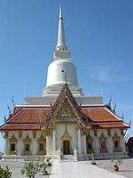
Wat Khao Suwan Pradit (Thai: วัดเขาสุวรรณประดิษฐ์) is a Buddhist temple on a hill about one kilometer from the town of Don Sak. The temple was founded in 1982 by Luang Pho Choi, a highly revered monk of southern Thailand. On top of the hill is a 45 meter high chedi, which contains Buddha relics which came from Wat Phra Kiat (Amphoe Hot, Chiang Mai Province).
Public services
Two ferry companies, Raja Ferry and Seatran, provide regular service to Samui and Pha Ngan Islands from piers in Don Sak. Travellers transiting from Surat Thani Airport en route to these islands typically embark from Don Sak.
Don Sak has one government-run hospital near Don Sak town.
References
- ↑ แจ้งความกระทรวงมหาดไทย เรื่อง โอนตำบล (PDF). Royal Gazette (in Thai). 46 (0 ง): 149. 1929-04-14.
- ↑ ประกาศกระทรวงมหาดไทย เรื่อง แบ่งท้องที่ตั้งเป็นกิ่งอำเภอ (PDF). Royal Gazette (in Thai). 86 (27 ง): 1206. 1 April 1969.
- ↑ ประกาศกระทรวงมหาดไทย เรื่อง เปลี่ยนแปลงเขตกิ่งอำเภอดอนสัก อำเภอกาญจนดิษฐ จังหวัดสุราษฎร์ธานี (PDF). Royal Gazette (in Thai). 86 (80 ง): 2851. 16 September 1969.
- ↑ พระราชกฤษฎีกาตั้งอำเภอปลาปาก อำเภอเชียงกลาง อำเภอปากชม อำเภอบ้านม่วง อำเภอพังโคน อำเภอดอนสัก อำเภอพนม อำเภอเวียงสระ อำเภอสังคม และอำเภอหัวตะพาน พ.ศ. ๒๕๑๔ (PDF). Royal Gazette (in Thai). 88 (123 ก): 745–748. 16 November 1971.
- ↑ ประกาศกระทรวงมหาดไทย เรื่อง ตั้งและเปลี่ยนแปลงเขตตำบลในท้องที่อำเภอเวียงสระ และอำเภอดอนสัก จังหวัดสุราษฎร์ธานี (PDF). Royal Gazette (in Thai). 95 (76 ง): 2456–2559. 1 August 1978.
External links
- amphoe.com (Thai)
- http://donsak.org Website of district (Thai)
- http://www.donsakcity.go.th Website of Don Sak Municipality (Thai)