Krabi Province
| Krabi กระบี่ | ||
|---|---|---|
| Province | ||
| ||
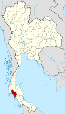 Map of Thailand highlighting Krabi Province | ||
| Country | Thailand | |
| Capital | Krabi | |
| Government | ||
| • Governor | Phinit Bunloet (since October 2015) | |
| Area | ||
| • Total | 4,709 km2 (1,818 sq mi) | |
| Area rank | Ranked 46th | |
| Population (2014) | ||
| • Total | 456,811 | |
| • Rank | Ranked 64th | |
| • Density | 97/km2 (250/sq mi) | |
| • Density rank | Ranked 62nd | |
| HDI | ||
| • HDI (2009) | 0.805 (high) (12th) | |
| Time zone | ICT (UTC+7) | |
| Area code(s) | 075 | |
| ISO 3166 code | TH-81 | |
| Vehicle registration | กระบี่ | |

Krabi (Thai: กระบี่, pronounced [krā.bìː]) is one of the southern provinces (changwat) of Thailand, on the shore of the Strait of Malacca. Neighbouring provinces are (from north clockwise) Phang Nga, Surat Thani, Nakhon Si Thammarat, and Trang. Phuket Province lies to the west across Phang Nga Bay. Krabi town is the seat of provincial government.
History
Circa 1200 CE, Krabi was tributary to the Kingdom of Ligor, a city on the Kra Peninsula's east coast, better known today as Nakhon Si Thammarat. In modern times, Krabi was administered from Nakhon Si Thammarat, even after 1872 when King Chulalongkorn granted Krabi town status. In 1875 it was made a direct subordinate of Bangkok, becoming what is now a province. In 1900 the governor moved the seat of the province from Ban Talad Kao to its present location at the mouth of the Krabi River.
It is believed the town may have taken its name from the word "krabi", which means "sword". This may stem from a legend that an ancient sword was unearthed prior to the city's founding.
Geography
The province is on the Strait of Malacca and is noted for its natural beauty. There are solitary limestone peaks, both on land and in the sea. Rock climbers from all over travel to Ton Sai Beach and Railay Beach. The beaches form part of Krabi's Phra Nang Peninsula. Of the 154 islands in the province, Ko Phi Phi Leh is the most famous, as it was the site of the movie The Beach. Other notable islands include Ko Phi Phi Don, part of the Phi Phi Islands, and Ko Lanta, a larger island to the south. The coast was damaged by the tsunami of 26 December 2004.
Krabi's limestone hills contain many caves, most having stalactites and stalagmites. Tham Chao Le and Tham Phi Hua To, both in Ao Luek District, contain prehistoric rock-paintings depicting humans, animals, and geometrical shapes. In Lang Rong Rien cave in 1986 archaeologists found 40,000-year-old human artifacts: stone tools, pottery, and bones. It is one of the oldest traces of human occupation in Southeast Asia. Krabi's caves are one of the main sources of nests of the edible-nest swiftlet, used in the making of bird's nest soup.
Krabi's farmland is dominated by a duopoly of rubber and palm oil plantations. Palm plantations alone occupy 980,000 rai (1,568 km2), or 52 percent of the province's farmland.[1] Together, palm oil and rubber cover 95 percent of Krabi's cultivated area with many smallholder farms amidst industrial plantations.[2]:5
Environment
In mid-2015, government plans to build an 800 megawatt coal-fired electricity generating station (EGAT Coal-Fired TH #3)[3]:13 in Tambon Pakasai in Amphoe Nuea Khlong have generated protests and hunger strikes by those opposed to the plant who say that it would endanger Krabi's relatively pristine environment. The Electricity Generating Authority of Thailand (EGAT) has pushed forward with development. The government intends to start the bidding process without an environmental assessment in order to "save time". The Krabi site is one of nine coal-fired plants planned for southern Thailand to be constructed over the next two decades to off-set the depletion of natural gas fields in the Gulf of Thailand. Opponents of the plan say their demands—which include a three-year waiting period to see if the province can produce 100 percent renewable energy—have been ignored.[4]
Thailand's resolve to go ahead with the massive new coal-fired power station in Krabi, a 315 MWe, 48 billion baht undertaking, presents a problem. Coal is a major source of mercury poisoning and has been found in toxic amounts up to 12 times more than the maximum acceptable dose in the inhabitants of Tha Thum in Prachinburi Province. Possible vectors are fly ash from the local coal power plant, coal dust from outdoor coal storage piles, or coal ash, used as fertiliser. These present risks to Krabi. "Clean coal" technology is still in its infancy and at the moment can only handle sulphur dioxide, nitrogen oxides, and particulates. Carbon dioxide sequestering is much more complex and costly.[5][6][7] Two academics, referring to clean coal in general, point out that, "So-called 'clean coal' is expensive, untested, unwieldy and unworkable, yet it is raised as a panacea."[8]
In mid-2016, a pro-renewables working group in Krabi published a "Green Power Development Plan". It concludes that Krabi Province can depend on renewables—mainly biomass and biogas—for 100 percent of its electricity needs. The report calculates that biomass could generate 118 MW in an initial three-year period; solar could generate 55 MW; biogas, 54 MW; and wind energy 40 MW. During a subsequent three-year period, renewables could generate 287 MW, exceeding the province's peak demand year of 2015, when it consumed 143 MW. If adopted, the plan would obviate the need to import coal, saving 175 billion baht over a 25 year period.[9]
In August 2016, EGAT solicited bids for the plant's construction and received bids in the range of 32-34.9 billion baht. The bidding process and the environmental and health impact assessment report were completed simultaneously. "After being delayed for almost two years, this November [2016] will be the time to decide whether to proceed or scrap the plan," said Energy Minister Gen Anantaporn Kanjanarat.[10]
Projected impact of changes in climate
In a 2008 study of the impact of climate change on Krabi Province to the year 2033, the following effects were projected:[2]:5,56
- Temperature: The study forecasts modest temperature changes, slightly more than 1˚C at inland locations over the next 10-25 years. Coastal temperatures will rise slightly less than 1˚C due to proximity to the moderating influence of the ocean.
- Rainfall: Annual monsoons will be two weeks shorter by 2018 and four weeks shorter by 2033. Total rainfall will likely decrease by 10 percent by 2033 according to the study.
- Sea level: Sea level will rise substantially, with negative implications for Krabi's mangrove wetlands. The rise of mean sea level on the Krabi coastline is projected to rise by about 1 cm annually over the next 25 years. If sea level rises by 20 cm over the next 25 years, existing 2008 shorelines will retreat 10-35 m.
- Tropical storms: Fewer cyclones are forecasted, although, as sea levels rise, storms may do more damage to coastal infrastructure.
Population and culture
Krabi's population includes Buddhists, Thai-Chinese, Moken (sea gypsies), and Muslims. Population is most dense in the coastal area in Nuea Khlong District and Krabi city districts, both with population densities above 150 people per km2. The least densely populated area is the inland mountain Khao Phanom District at 61 persons per km2. Buddhism is the religion most observed (66 percent) followed by Muslim (33 percent). Krabi has been little affected by the Muslim militant insurgency that has plagued the southern provinces of Thailand since 2003. Traditionally Krabi's inhabitants worked in agriculture, for the province is rich in rubber, palm oil, and oranges. In recent years tourism has become an important source of income.[2]:7
Symbols
The seal of the province shows two ancient crossed swords ("krabi" is the word for an ancient Siamese sword) in front of the Indian Ocean and Khao Phanom Bencha mountain which, at 1,397 metres (4,580 ft) above sea level, is the highest mountain of the province.[11]
The provincial slogan is, "Krabi, the liveable city, friendly people."[11]
The provincial tree is the thung-fa (Thai: ทุ้งฟ้า) or Alstonia macrophylla.
Administrative divisions
Krabi is subdivided into eight districts (amphoe), which are further divided into 53 communes (tambon) and 374 villages (muban).
| Map | Number | Name | Thai |
|---|---|---|---|
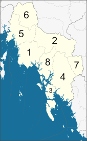 | |||
| 1 | Mueang Krabi | เมืองกระบี่ | |
| 2 | Khao Phanom | เขาพนม | |
| 3 | Ko Lanta | เกาะลันตา | |
| 4 | Khlong Thom | คลองท่อม | |
| 5 | Ao Luek | อ่าวลึก | |
| 6 | Plai Phraya | ปลายพระยา | |
| 7 | Lam Thap | ลำทับ | |
| 8 | Nuea Khlong | เหนือคลอง |
References
- ↑ Atthakor, Ploenpote (20 August 2016). "Govt needs to get fired up over renewables". Bangkok Post. Retrieved 20 August 2016.
- 1 2 3 World Wildlife Fund Greater Mekong Program (WWF-GMP); South East Asian-Global Change System for Analysis, Research and Training organisation (SEA-START) (December 2008). Climate Change Impacts in Krabi Province, Thailand. A study of environmental, social, and economic challenges (PDF). Retrieved 4 October 2016.
- ↑ "Summary of Thailand Power Development Plan 2012 – 2030 (PDP2010: Rev 3)" (PDF). Electricity Generating Authority of Thailand (EGAT). Ministry of Energy, Energy Policy and Planning Office. June 2012. p. 13. Retrieved 22 July 2015.
- ↑ Andersen, Ted (2015-07-21). "Hunger strikes, protests to oppose Thailand's plan for coal plants on Andaman Coast". U.S. News & World Report. Associated Press. Retrieved 22 July 2015.
- ↑ Draper, John; Kamnuansilpa, Peerasit (2015-08-27). "Thailand's power dilemma amid a climate of fear". The Nation. Retrieved 27 August 2015.
- ↑ Paradise at Risk: The Krabi Coal-fired Power Plant Project (PDF). Bangkok: Greenpeace Southeast Asia. 2014. Retrieved 14 January 2016.
- ↑ Meigs, James B (2011-07-14). "The Myth of Clean Coal: Analysis". Popular Mechanics. Retrieved 18 October 2016.
- ↑ Wilder, Robert; Kammen, Daniel M (19 October 2016). "Exposed: The Climate Fallacy of 2100". Scientific American. Retrieved 21 October 2016.
- ↑ Atthakor, Ploenpote (20 August 2016). "Govt needs to get fired up over renewables". Bangkok Post. Retrieved 25 August 2016.
- ↑ Praiwan, Yuthana (4 October 2016). "Call on Krabi coal plant due in November". Bangkok Post. Retrieved 4 October 2016.
- 1 2 "Symbol of Krabi". OSM Andamnan: The Office of Strategy Management for Southern Province Cluster. Retrieved 26 May 2015.
External links
| Wikimedia Commons has media related to Krabi Province. |
 Krabi Province travel guide from Wikivoyage
- Provincial Website (Thai)
- Golden Jubilee Network province guide Archived October 25, 2014, at the Wayback Machine.
 |
Phang Nga Province | Surat Thani Province | | |
| Phuket Province | |
Nakhon Si Thammarat Province | ||
| ||||
| | ||||
| Andaman Sea | Trang Province |
Coordinates: 8°03′28″N 98°55′01″E / 8.05778°N 98.91694°E