Parrita (canton)
| Parrita | |
|---|---|
| Cantón | |
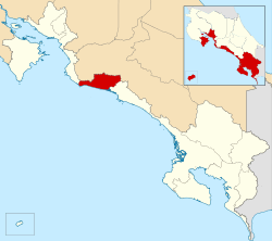 Location of Parrita Canton in Puntarenas Province | |
| Country | Costa Rica |
| Province | Puntarenas |
| Founded | 5 July 1971 |
| Area | |
| • Total | 478.79 km2 (184.86 sq mi) |
| Population (June 2013) | |
| • Total | 17,587 |
| • Density | 37/km2 (95/sq mi) |
Parrita is the ninth canton in Puntarenas Province in Costa Rica. The canton covers an area of 478.79 km²,[1] and has a population of 17,587.[2] Its capital city is Parrita de Puntarenas.
Geography
The canton lies along the central Pacific coast between the mouths of the Tusubres River and Damas River. Inland the canton is delineated by a series of rivers that meander through the valleys of the coastal mountain range.
The canton of Parrita is one of only two cantons in Costa Rica that is not subdivided into distritos (districts), and so the canton also functions and provides the government services assigned to district-level administration.
History
The canton was created by law on July 5, 1971.
Almost all of Costa Rican territory was inhabited before the arrival of the Spanish. The Huetars lived in this area. In 1924, a young German installed the first banana plantation near the Pirris River (also called the Parrita River) which encouraged migration of people from San Jose and Guanacaste. The origin of the name, it is said, has to do with a woman named Rita who lived in one of the original settlements. Rita had a business and received packages. "Es pa' Rita" (It's for Rita) was often heard so the canton was called Parrita.[3]
References
- ↑ Instituto Geográfico Nacional (IGN), 2001.
- ↑ Estadísticas Vitales 2013 - INEC
- ↑ http://www.1-costaricalink.com/costa_rica_provinces/puntarenas_costa_rica/parrita_costa_rica.htm
Coordinates: 9°31′12″N 84°19′12″W / 9.52000°N 84.32000°W