Cartago (canton)
| Cartago | |||
|---|---|---|---|
|
Cantón | |||
 | |||
| |||
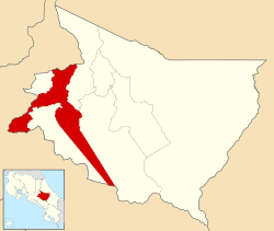 Location of Cartago Canton in Cartago Province | |||
| Country | Costa Rica | ||
| Province | Alajuela | ||
| Founded | 7 December 1848 | ||
| Area | |||
| • Total | 287.77 km2 (111.11 sq mi) | ||
| Population (June 2013) | |||
| • Total | 154,822 | ||
| • Density | 540/km2 (1,400/sq mi) | ||


Cartago is the first canton in the province of Cartago in Costa Rica.[1] The canton covers an area of 287.77 square kilometres (111.11 sq mi),[2] and has a population of 154,82 (estimate as of 2013).[3] The provincial capital of Cartago is also the capital city of the canton.
Geography
Cartago is a T-shaped canton stretching southeast from its capital city to encompass a thin swatch of the Cordillera de Talamanca (Talamanca Mountain Range), and including portions of the Interamericana (Pan-American Highway).
Districts
The canton of Cartago is subdivided into 11 districts (distritos)[1]
| District | Population |
|---|---|
| Oriental | 12,425 |
| Occidental | 10,130 |
| Carmen (El Carmen) | 18,207 |
| San Nicolás (also known as Taras) | 27,349 |
| Aguacaliente (also known as San Francisco) | 33,338 |
| Guadalupe (also known as Arenilla) | 15,338 |
| Corralillo | 11,247 |
| Tierra Blanca | 5,365 |
| Dulce Nombre | 11,177 |
| Llano Grande | 4,600 |
| Quebradilla | 5,646 |
History
Cartago was first mentioned as a canton in a decree dated December 7, 1848.
References
- 1 2 "División Territorial Administrativa de Costa Rica" (PDF) (in Spanish). Instituto de Fomento y Asesoria Municipal (IFAM). 5 May 2009. Archived from the original (PDF) on 2015-08-02.
- ↑ Instituto Geográfico Nacional (IGN), 2001.
- ↑ Estadísticas Vitales 2013 - INEC
Coordinates: 9°51′09″N 83°55′26″W / 9.85251°N 83.923874°W
This article is issued from Wikipedia - version of the 11/16/2016. The text is available under the Creative Commons Attribution/Share Alike but additional terms may apply for the media files.