Paraná Valles
|
CTX context image for next image that was taken with HiRISE. Note long ridge going across image is probably an old stream. Box indicates area for HiRISE image. | |
| Coordinates | 23°06′S 10°12′W / 23.1°S 10.2°WCoordinates: 23°06′S 10°12′W / 23.1°S 10.2°W |
|---|---|
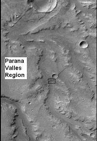
Paraná Valles is a valley in the Margaritifer Sinus quadrangle (MC-19) region of Mars, located at approximately 23.1° South and 10.2° West. It is 350 km long and was named after an ancient and modern name for a South American river (Brazil, Argentina).[1] A low area between Paraná Valles and Loire Valles is believed to have once held a lake.[2][3]
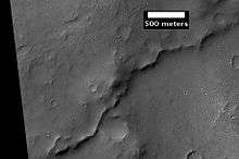 Example of inverted terrain in Paraná Valles region, as seen by HiRISE under the HiWish program.
 Paraná Valles, as seen by HiRISE. Scale bar is 1000 meters long.
References
- ↑ "Paraná Valles". Gazetteer of Planetary Nomenclature. USGS Astrogeology Science Center. Retrieved 2014-07-11. External link in
|work=(help) - ↑ Goldspiel, J. and S. Squyres. 2000. Groundwater sapping and valley formation on Mars. Icarus. 89: 176-192.
- ↑ Michael H. Carr (2006). The surface of Mars. Cambridge University Press. ISBN 978-0-521-87201-0. Retrieved 21 March 2011.
This article is issued from Wikipedia - version of the 11/3/2016. The text is available under the Creative Commons Attribution/Share Alike but additional terms may apply for the media files.