Panola Mountain
| Panola Mountain State Park | |
|---|---|
|
Granite outcrop, Panola Mountain | |
 Map of Georgia | |
| Location | Stockbridge, Georgia |
| Coordinates | 33°38′7″N 84°10′13″W / 33.63528°N 84.17028°WCoordinates: 33°38′7″N 84°10′13″W / 33.63528°N 84.17028°W |
| Area | 1,635 acres (662 ha) |
| http://gastateparks.org/info/panolamt/ | |
| Designated | 1980 |
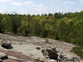
Panola Mountain is a 100-acre (40 ha) granite monadnock near Stockbridge on the boundary between Henry County and Rockdale County, Georgia. The peak is 946 feet (288 m) above sea level, rising 260 feet (79 m) above the South River. The South River marks the boundary between Henry/Rockdale counties and DeKalb County, Georgia. Due to its delicate ecological features, Panola Mountain was designated a National Natural Landmark in 1980.[1]
References
- ↑ "Panola Mountain". nps.gov. National Park Service.
External links
This article is issued from Wikipedia - version of the 11/19/2016. The text is available under the Creative Commons Attribution/Share Alike but additional terms may apply for the media files.