Fort McAllister Historic State Park
| Fort McAllister Historic State Park | |
|---|---|
|
Inside the fort | |
| Location | Bryan County, Georgia, USA |
| Nearest city | Richmond Hill, Georgia |
| Coordinates | 31°53′28″N 81°11′46″W / 31.89111°N 81.19611°WCoordinates: 31°53′28″N 81°11′46″W / 31.89111°N 81.19611°W |
| Area | 30 acres (12 ha) |
| Governing body | State |
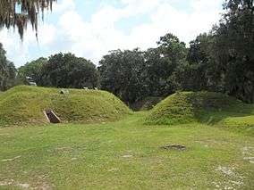
Fort McAllister Historic Park is a 1,725-acre (698 ha) Georgia state park located near Keller and Richmond Hill in south Bryan County, Georgia and on the south bank of the Ogeechee River (some parts of the park border the Atlantic Ocean). The park is home to Fort McAllister, the best-preserved earthwork fortification of the Confederacy. Though the earthworks were attacked unsuccessfully seven times by Union soldiers, it did not fall until it was taken by General Sherman in 1864 during his infamous March to the Sea. The park, located on the coast, is nestled among giant live oaks and a large salt marsh. In addition, the park contains a museum specializing in Civil War artifacts. The fort was added to the National Register of Historic Places in 1970.
Facilities
- 65 tent/trailer/RV sites
- 7 cottages
- 3 picnic shelters
- Pioneer camping
- Hiking trail - 4.3 miles of trails - One is 3.1 miles long and the other 1.2 miles long
- Boat ramps
- Playground
Annual events
- 4th of July Barbecue, Picnic and Craft Show (July)
- Fort tours
- Labor Day and Winter Musters
- Super Sundays
Photos
 Sign at the entrance of the park
 Historical markers a few miles away
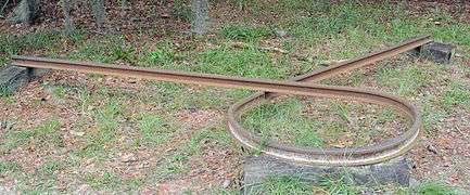 A Sherman necktie, mutilated railroad track
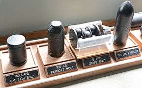 Some munitions on display in the museum
 Captured Fort McAllister flag
 A fort battle flag
See also
- Battle of Fort McAllister (1863)
- Battle of Fort McAllister (1864)
- Battle of Fort Pulaski
- Fort McAllister
- National Register of Historic Places in Bryan County, Georgia
References
External links
-
 Media related to Fort McAllister Historic Park at Wikimedia Commons
 - Fort McAllister Historic Park