Ocmulgee National Monument
| Ocmulgee National Monument | |
|---|---|
|
IUCN category V (protected landscape/seascape) | |
|
The Great Temple Mound (right) and the Lesser Mound (left) | |
 | |
| Location | Macon, Georgia, USA |
| Coordinates | 32°50′12″N 83°36′30″W / 32.83667°N 83.60833°WCoordinates: 32°50′12″N 83°36′30″W / 32.83667°N 83.60833°W |
| Area | 701.54 acres (283.90 ha)[1] |
| Established | December 23, 1936 |
| Visitors | 122,722 (in 2011)[2] |
| Governing body | National Park Service |
| Website | |
| NRHP Reference # | 66000099[3] |
| Added to NRHP | October 15, 1966 |

Ocmulgee National Monument preserves traces of over ten millennia of Southeastern Native American culture, including major earthworks built before 1000 CE by the South Appalachian Mississippian culture (a regional variation of the Mississippian culture.)[4] These include the Great Temple and other ceremonial mounds, a burial mound, and defensive trenches. They represented highly skilled engineering techniques and soil knowledge, and the organization of many laborers. The site has evidence of "17,000 years of continuous human habitation."[5] The 702-acre (2.84 km2) park is located on the east bank of the Ocmulgee River. Present-day Macon, Georgia developed around the site after the United States built Fort Benjamin Hawkins nearby in 1806.
Varying cultures of prehistoric indigenous peoples settled on what is called the Macon Plateau at the Fall Line, where the rolling hills of the Piedmont met the Atlantic Coastal Plain. The monument designation includes the Lamar Mounds and Village Site, located downriver about three miles (5 km) from Macon. The monument park was designated for federal protection by the National Park Service (NPS) in 1934 and listed on the National Register of Historic Places in 1966. In 1997, the NPS designated the monument a Traditional Cultural Property, the first so recognized east of the Mississippi River.
National Monument
While the mounds had been studied by some travelers, professional excavation under the evolving techniques of archeology did not begin until the 1930s, under the administration of President Franklin D. Roosevelt during the Great Depression. The Works Progress Administration (WPA) sponsored large-scale archaeological digs at the site between 1933 and 1942. Workers excavated portions of eight mounds, finding an array of significant archeological artifacts that revealed a wide trading network and complex, sophisticated culture.[6] On June 14, 1934, the park was authorized as a National Monument and formally established on December 23, 1936 under the National Park Service. As an historic unit of the Park Service, the National Monument was listed on the National Register of Historic Places on October 15, 1966.
In the early 1990s, the National Park Service renovated its facilities at the park. In 1997, it designated the Ocmulgee National Monument as a Traditional Cultural Property, the first such site named east of the Mississippi River.
Ocmulgee's visitor center includes an archaeology museum. It displays artifacts and interprets the successive cultures of the prehistoric Native Americans who inhabited this site, as well as the historic Muscogee and diverse peoples of the colonial era. The large park encompasses 702 acres (2.84 km2), with 5 1⁄2 miles (8.9 km) of walking trails. Near the visitor center is a reconstructed ceremonial earthlodge, based on a 1,000-year-old structure excavated by archeologists. Visitors can reach the Great Temple Mound via a half-mile walk or the park road. Other surviving prehistoric features in the park include a burial mound, platform mounds, and earthwork trenches.
The historic site of the English colonial Ocumulgee trading post is also part of the park. The visitor center includes a short orientation film for the monument site and a gift shop.
The main section of Ocmulgee National Monument is accessible from U.S. Route 80, off Interstate 16 (which passes through the southwest edge of the monument land). It is open daily except Christmas Day and New Year's Day.
The Lamar Mounds and Village Site is an isolated unit of the monument, located in the swamps about 3 miles (4.8 km) south of Macon. The Lamar Site is open on a limited basis.
History
Macon Plateau culture
Ocmulgee (pronounced "oak-mull-ghee") is a memorial to ancient indigenous peoples in Southeastern North America. From Ice Age hunters to the Muscogee (Creek) of historic times, the site has evidence of 17,000 years of human habitation. The Macon plateau was inhabited during the Paleoindian, Archaic, and Woodland phases.
The major occupation was ca. 950-1150 during the Early Mississippian-culture phase. The people of this sophisticated, stratified culture built the complex, massive earthworks that expressed their religious and political system.[7] Archeologists call this society the Macon Plateau culture, a local expression of the Mississippian culture.[8] During this period, an elite society supported by skillful farmers constructed a town. Leaders directed the complex construction of large, earthwork mounds, the central structures on the plateau.
Carrying earth by hand in bags, thousands of workers built the 55 ft (17 m).-high Great Temple Mound on a high bluff overlooking the floodplain of the Ocmulgee River. Magnetometer scans have revealed the platform mound had a spiraling staircase oriented toward the floodplain. The staircase is unique among any of the Mississippian-culture sites. Other earthworks include at least one burial mound.
The people built rectangular wooden buildings to house certain religious ceremonies on the platform mounds. The mounds at Ocmulgee were unusual because they were constructed more distant from each other than was typical of other Mississippian complexes. Scholars believe this was to provide for public space and residences around the mounds.
Circular earth lodges were built to serve as places to conduct meetings and important ceremonies. Remains of one of the earth lodges were carbon dated to 1050 CE. This evidence was the basis for the reconstructed lodge which archeologists later built at the monument center. The interior features a raised-earth platform, shaped like an eagle with a forked-eye motif. Molded seats on the platform were built for the leaders. The eagle was a symbol of the Southeastern Ceremonial Complex, which the people shared with other Mississippian cultures.
Lamar Phase
As the Mississippian culture declined at the ceremonial center, ca. 1350 a new culture coalesced among people who lived in the swamps downstream. The Late Mississippian period Lamar Phase people built two mounds that have survived, including a unique "spiral mound." They also had a village protected by a defensive palisade. This is now protected as the Lamar Mounds and Village Site.[9]
Lamar pottery was distinctive, stamped with complex designs like pottery of the earlier Woodland peoples. It was unlike the pottery of the Macon Plateau culture. Many archaeologists believe the Lamar were related to the earlier Woodland inhabitants, who, after being displaced by the newer Mississippian culture migrants, developed a hybrid culture.
Spanish contact
In 1540 the expedition of Spanish conquistador Hernando de Soto recorded its travel through the chiefdom of Ichisi Historians and archeologists believe this was likely the Lamar site.[10] The Spaniards left a trail of destruction in their wake as they wandered throughout the present-day Southeastern U.S. in a failed search for precious metals. Their deadliest legacy was likely related to the pigs they brought. Escaping, the pigs became feral and spread Eurasian infectious diseases to which American Indians had no acquired immunity. Fatalities were high, causing social dislocations and likely contributing to a collapse of the Mississippian cultures.[11]
In the aftermath of De Soto's expedition, the Mississippian cultures disappeared. Hierarchical chiefdoms crumbled. They were replaced by loose confederacies of clans. The clans did not cultivate the agricultural surpluses which had supported the former population density. Agriculture had enabled the development of hierarchy in the larger population. Its leaders planned and directed the corvée labor system that raised and maintained the great earthen mounds.
Historic period
By the late 18th century, the largest American Indian confederacy in present-day Georgia and Alabama was the Muscogee (known during the colonial and federal periods as the Creek Indians), part of the Muskogean-speaking peoples. They considered the ancient Mississippian mounds at Ocmulgee to be sacred and made pilgrimages there. According to Muscogee oral tradition, the mounds area was "the place where we first sat down," after their ancestors ended their migration journey from the West.[12]
In 1690, Scottish fur traders from Carolina built a trading post on Ochese Creek (Ocmulgee River), near the Macon Plateau mounds. Some Muscogee created a village along the Chattahoochee River near the post, where they could easily acquire trade goods. They defied efforts by Spanish Florida to bring them into the mission province of Apalachee.[13]
The traders referred to both the river and the peoples living along it as Ochese Creek. Later usage shortened the term to Creek, which traders and colonists applied to all Muskogean-speaking peoples.[13] The Muscogee called their village near the trading-post Ocmulgee (bubbling waters) in the local Hitchiti language. The British colonists called it Ocmulgee Town, later the basis of their naming the river.
The Muscogee traded pelts of white tailed deer and Indian slaves captured in raids against other tribes. They received West Indian rum, cloth, glass beads, axes, swords, and flintlocks. Carolinian fur traders, who were men of capital, took Muscogee wives, often the daughters of chiefs. It was a practice common also among the British fur traders in Canada; both the fur traders and American Indians saw such marriages as a way to increase the alliances among the elite of both cultures. The fur traders encouraged the Muscogee slaving raids against Spanish "Mission Indians." British colonists were so few in number that they depended on Indian alliances for security and survival.
In 1702 South Carolina Governor Col. James Moore raised a militia of 50 colonists and 1,000 Yamasee and Ochese Creek warriors. From 1704 to 1706, they attacked and destroyed a significant number of Spanish missions of coastal Georgia and Florida. They captured numerous Mission Indians: the Timucua and Apalachee, some of whom the colonists and their Indian allies sold into slavery. Together with extensive fatalities from infectious disease epidemics, the warfare caused Florida's indigenous population to fall from about 16,000 in 1685 to 3,700 by 1715.[14]
As Florida was depopulated, the English-allied tribes grew indebted to slave traders. They paid other tribes to attack and enslave Indians, raids that were a catalyst for the Yamasee War in 1715. In an effort to drive the colonists out, the Ochese Creek joined the rebellion and burned the Ocmulgee trading post. In retaliation, South Carolina began arming the Cherokee, whose attacks forced the Ochese Creek to abandon the Ocmulgee and Oconee rivers, and move west to the Chattahoochee. The Yamasee took refuge in Spanish Florida.
With the defeat of the Yamasee, the English created the new colony of Georgia, founding Savannah on the coast in 1733. Although various development schemes were started (silkworm cultivation, production of naval stores), the colony did not become profitable until after Georgia ended its prohibition of slavery. The earliest intention of the founders had been to provide a colony for hardworking English laborers but not enough were willing to bear its conditions. The colony began to import African slaves as laborers and to develop the labor-intensive rice, cotton and indigo plantations in the 1750s in the Low Country. These commodity crops, based on slave labor, made the wealth of the planter elite of South Carolina.
Because of continuing conflicts with land-hungry European settlers and other Muscogee groups, many Ochese Creek migrated from Georgia to Florida in the 18th century. There they joined with earlier refugees of the Yamasee War, remnants of Mission Indians, and escaped African slaves, to form a new tribe which they called the Seminole.
The Ocmulgee mounds evoked awe in early travelers. The Naturalist William Bartram journeyed through Ocmulgee in 1774 and 1776. He described the "wonderful remains of the power and grandeur of the ancients in this part of America."[15] He was the first to record the Muscogee oral histories of the mounds' origins.
The Lower Creek of Georgia initially had good relations with the federal government of the United States, based on the diplomacy of both Benjamin Hawkins, President George Washington's Indian agent, and the Muscogee Principal Chief Alexander McGillivray. The son of Sehoy, a Muscogee woman of the Wind Clan, and Lachlan McGillivray, a wealthy Scottish fur trader, Alexander McGillivray achieved influence both within the matrilineal tribe because of his mother's family, and among the Americans because of his father's position and wealth. In 1790 he secured U.S. recognition of Muscogee and Seminole sovereignty by the Treaty of New York. But, after the invention of the cotton gin in 1794 made cultivation of short-staple cotton more profitable, Georgians were eager to acquire Muscogee corn-fields of the uplands area to develop as cotton plantations; they began to encroach on the native territory.
Under government pressure in 1805, the Lower Creeks ceded their lands east of the Ocmulgee River to the state of Georgia, but they refused to surrender the sacred mounds. They retained a 3×5-mile-square area on the east bank called the Ocmulgee Old Fields Reserve. It included both the mounds on the Macon Plateau and the Lamar mounds.
In 1806 the Jefferson administration ordered Fort Benjamin Hawkins built on a hill overlooking the mounds. The fort was of national and state military importance through 1821, used as a US Army command headquarters, and a supply depot for campaigns in the War of 1812 and later. Economically, it was important as a trading post or factory to regulate the Creek Nation's trade in deerskins. In addition, it served as a headquarters and mustering area for the Georgia state militia, so was a point of contact among the Creek Nation, the US, and the state of Georgia military and political representatives.[16]
Tensions among the Upper Creek and Lower Creek towns increased with encroachment by European-American settlers in Georgia. Many among the Upper Creek wanted to revive traditional culture and religion, and a young group of men, the Red Sticks, formed around their prophets. The US and Georgia forces used the fort during the Creek War of 1813-1814. At the Battle of Horseshoe Bend in 1814, General Andrew Jackson defeated the Red Stick faction of the Upper Creek. Together with their own issues, they had been influenced by the Shawnee chief Tecumseh and were seeking to drive the Americans out of their territory. The Lower Creek fought alongside the U.S. against the Red Sticks.
Led by Chief William McIntosh, the Lower Creek also allied with the United States in the First Seminole War. McIntosh's influence in the area was extended by his family ties to Georgia's planter elite through his wealthy Scots father by the same name. He was connected to the McGillivray clan. A resident of Savannah, the senior McIntosh had strong ties to the British and had been a Tory officer during the American Revolution. He tried to recruit the Lower Creek to fight for the British in the war. Remaining in the new United States, he became a cotton planter after the war.
In 1819, the Lower Creek gathered for the last time at the Ocmulgee Old Fields. In 1821, Chief McIntosh agreed to the first Treaty of Indian Springs, by which the Lower Creek ceded their lands east of the Flint River, including the Ocmulgee Old Fields. In 1822 the state chartered Bibb County, and the following year the town of Macon was founded.
The Creek National Council struggled to end such land cessions by making them a capital offense. But in 1825, Chief McIntosh and his paternal cousin Georgia Governor George Troup negotiated an agreement with the US. McIntosh and several other Lower Creek chiefs signed the second Treaty of Indian Springs in 1825. McIntosh ceded the remaining Lower Creek lands to the United States, and the Senate ratified the treaty by one vote, despite its lacking the signature of the Muscogee Principal Chief William McIntosh. Soon after that, the chief Menama and 200 warriors attacked McIntosh's plantation. They killed him and burned down his mansion in retaliation for his alienating communal lands.
William McIntosh and a Muscogee delegation from the National Council went to Washington to protest the treaty to President John Quincy Adams. The US government and the Creek negotiated a new treaty, called the Treaty of New York (1826), but the Georgia state government proceeded with evicting Creek from lands under the 1825 treaty. It also passed laws dissolving tribal government and regulating residency on American Indian lands.
In 1828, Andrew Jackson was elected president, and he supported Indian removal, signing legislation to that effect by Congress in 1830. Later he used US Army forces to remove the remnants of the Southeastern Indian tribes through the 1830s. The Creek, the Cherokee, the Choctaw, the Chickasaw and the Seminole were all removed to Indian Territory.
Following Indian Removal, the Muscogee reorganized in the Indian Territory (now Oklahoma). In 1867 they founded a new capital, which they called Okmulgee in honor of their sacred mounds on the plateau of the Georgia fall line.[17]
Images
 park entrance sign
 Looking upward to the Great Temple Mound from the bluff above the Ocmulgee River
 view from top of Great Temple Mound
 The Great Temple Mound
Archaeology Museum
 Pipes, necklaces, and a pottery vessel with a lid the shape of a human head, found at Ocmulgee
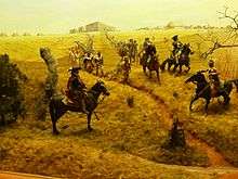 Col. Moore's raiding party passes the Ocmulgee trading-post
 Earth Lodge Display
 detail of museum
Ocmulgee Earth Lodge
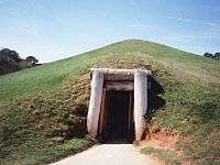 entrance to earth lodge
 interior of earth lodge
 interior of earth lodge
 Earthlodge fireplace. Nearby were 47 molded seats where the high chiefs or priests sat on the eagle platform
 information sign
See also
References
- ↑ "Listing of acreage as of December 31, 2011". Land Resource Division, National Park Service. Retrieved 2012-05-14.
- ↑ "NPS Annual Recreation Visits Report". National Park Service. Retrieved 2012-05-14.
- ↑ National Park Service (2010-07-09). "National Register Information System". National Register of Historic Places. National Park Service.
- ↑ "Southeastern Prehistory:Mississippian and Late Prehistoric Period". National Park Service. Retrieved 2012-04-10.
- ↑ "Ocmulgee National Monument", National Park Service, accessed 15 July 2011
- ↑ David Holly, "Macon Plateau", in Guy E. Gibbon, Ed., Archaeology of Prehistoric Native America: An Encyclopedia, New York: Routledge, 1998, p. 601
- ↑ David J. Holly, "Macon Plateau", in Archaeology of Prehistoric Native America: An Encyclopedia, p. 601
- ↑ "Macons Mississippians". Retrieved 2010-01-16.
- ↑ "Ocmulgee National Monument", National Park Service
- ↑ "Hernando de Soto", National Park Service
- ↑ Charles C. Mann, 1491: New Revelations on the Americas Before Columbus, pp. 107-110
- ↑ Sacred Sites International Foundation - Ocmulgee Old Fields
- 1 2 "Notice of Inventory Completion for Native American Human Remains and Associated Funerary Objects ... Ocmulgee National Monument,", Federal Register Notice, National Park Service
- ↑ Alan Taylor, American Colonies: The Settling of North America, New York: Penguin Books: 2001, p. 233
- ↑ "Ocmulgee National Monument", Colonial History, National Park Service
- ↑ Daniel T. Elliott, Fort Hawkins: 2005-2007 Field Seasons, The LAMAR Institute, Report 124, 2008, p. 1, accessed 16 July 2011
- ↑ "Muscogee", Oklahoma History and Culture
- The National Parks: Index 2001–2003. Washington: U.S. Department of the Interior.
External links
| Wikimedia Commons has media related to Ocmulgee National Monument. |
- Official NPS website: Ocmulgee National Monument
- Virtual Tour of Ocmulgee
- Ocmulgee National Monument: 3 Mile Hiking Loop
- Ocmulgee Mounds, New Georgia Encyclopedia
- Lamar Mounds coordinates: 32°48′45″N 83°35′34″W / 32.81250°N 83.59278°W
| Archaeological cultures |
|
|---|---|
| Archaeological sites |
|
| Human remains | |
| Miscellaneous |
|
| |
| Topics | |
|---|---|
| Lists by states |
|
| Lists by insular areas | |
| Lists by associated states | |
| Other areas | |
| |