Painesdale, Michigan
| Painesdale, Michigan | |
|---|---|
| Unincorporated community | |
|
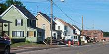
Looking south along M-26 | |
 Painesdale, Michigan | |
| Coordinates: 47°02′36″N 88°40′20″W / 47.04333°N 88.67222°WCoordinates: 47°02′36″N 88°40′20″W / 47.04333°N 88.67222°W[1] | |
| Country | United States |
| State | Michigan |
| County | Houghton |
| Township | Adams |
| Elevation[1] | 1,299 ft (396 m) |
| Time zone | Eastern (EST) (UTC-5) |
| • Summer (DST) | EDT (UTC-4) |
| ZIP code | 49955 |
| Area code(s) | 906 |
| GNIS feature ID |
634293[1] |
|
Painesdale, Michigan | |
| NRHP Reference # | 93000623 |
| Added to NRHP | July 16, 1993 |

Painesdale is an unincorporated community in Houghton County, Michigan, United States. Painesdale is located in Adams Township along M-26, 2.5 miles (4.0 km) southwest of South Range.[2] Painesdale has a post office with ZIP code 49955.[3]
History
Painesdale was built by the Champion Mining Company between 1899 and 1917, and named after the Boston businessman William A. Paine, who was associated with many mines as well as the Paine Webber brokerage.[4] Painesdale was located near the copper load, and the company designed the town following theories of efficient planning.[4]
Champion's copper mine was an important producer from 1900 to 1930, and continued sporadic production until the late 1960s.[4] Painesdale experienced labor strikes in 1904 and 1913, the latter being long remembered for its violence.[5]
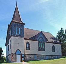
During the Cold War, Painesdale had an Air Defense Command radar station of the Permanent System radar network (P-16A, 47°02′12″N 088°41′43″W / 47.03667°N 88.69528°W). In 1993, the town was added to the National Register of Historic Places.[5] The designation applies to the area encompassing Painesdale streets and the Champion Mine.[6]
Description
Painesdale contains rows of identical saltbox workers' houses as well as managers' houses that were more individualized.[4] A single shaft house from the Champion Mine is still in the lower part of town, surrounded by other substantial mine buildings.[4]
See also
References
- 1 2 3 U.S. Geological Survey Geographic Names Information System: Painesdale, Michigan
- ↑ Houghton County (pdf) (Map). Michigan Department of Technology, Management and Budget. 2010. Retrieved 2010-12-25.
- ↑ ZIP Code Lookup, United States Post Office
- 1 2 3 4 5 "Painesdale". Michigan State Housing Development Authority: Historic Sites Online. Retrieved June 20, 2011.
- 1 2 Bogue, Margaret Beattie (2007). Around the Shores of Lake Superior: A Guide to Historic Sites, p. 300. The University of Wisconsin Press.
- ↑ National Register of Historic Places.
Municipalities and communities of Houghton County, Michigan, United States | ||
|---|---|---|
| Cities | 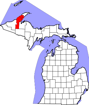 | |
| Villages | ||
| Charter townships | ||
| General law townships | ||
| CDPs | ||
| Other unincorporated communities | ||