Pacific Heights, San Francisco
| Pacific Heights | |
|---|---|
| Neighborhood | |
|
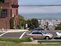
Northern view from Alta Plaza Park. The Marina District and San Francisco Bay can be seen below. | |
| Nickname(s): The Devil's Backbone | |
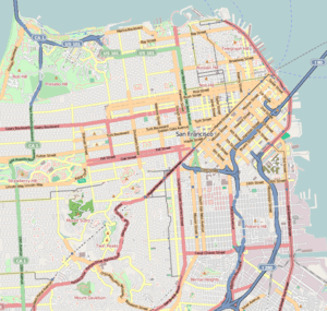 Pacific Heights Location within Central San Francisco | |
| Coordinates: 37°47′30″N 122°26′08″W / 37.7917°N 122.4356°W | |
| Country |
|
| State |
|
| City-county | San Francisco |
| Government | |
| • Supervisor | Mark Farrell |
| • State Assembly | Phil Ting (D)[1] |
| • State Senator | Scott Wiener (D)[1] |
| • U. S. Rep. | Nancy Pelosi (D)[2] |
| Area | |
| • Total | 0.967 sq mi (2.50 km2) |
| • Land | 0.967 sq mi (2.50 km2) |
| Population | |
| • Total | 21,925 |
| • Density | 22,677/sq mi (8,756/km2) |
| Time zone | Pacific (UTC−8) |
| • Summer (DST) | PDT (UTC−7) |
| ZIP codes | 94109, 94115, 94123 |
| Area codes | 415/628 |
| [3] | |
Pacific Heights is an affluent neighborhood of San Francisco, California, which is known for the notable people who reside in the area. It is located in one of the most scenic and park-like settings in northern California, offering panoramic views of the Golden Gate Bridge, San Francisco Bay, the Palace of Fine Arts, Alcatraz, and the Presidio. Its location provides a temperate micro-climate that is clearer, but not always warmer, than many other areas in San Francisco.
The Pacific Heights Residents Association defines the neighborhood as inside Bush Street, Presidio Avenue, Union Street, and Van Ness Avenue.[4]
Pacific Heights is situated on a primarily east-west oriented ridge that rises sharply from the Marina District and Cow Hollow neighborhoods to the north to a maximum height of 370 feet (110 m) above sea level.[5] Pacific Heights features two parks, Lafayette and Alta Plaza. Visible to the north are the Golden Gate Bridge, the Marin Headlands, and Alcatraz Island.
Lower Pacific Heights refers to the area located south of California Street down to Post Street. Though previously simply considered part of the Western Addition,[6] this new neighborhood designation became popularized by real estate agents in the early 1990s.
History
The neighborhood was first developed in the 1870s,[7] with small Victorian-inspired homes built. Starting around the beginning of the 20th century, and especially after the 1906 San Francisco earthquake, many were replaced with period homes. Still residential, the area is characterized by painted Victorian style architecture.
Attractions and characteristics
The oldest building in Pacific Heights, located at 2475 Pacific Avenue, was built in 1853, though the majority of the neighborhood was built after the 1906 earthquake. The architecture of the neighborhood is varied; Victorian, Mission Revival, Edwardian, and Château styles are common.
Several countries have consulates in Pacific Heights. They include Germany,[8] Greece,[9] Italy,[10] Portugal,[11] Russia,[12] South Korea,[13] and Vietnam.[14]
Most of the neighborhood's boutiques and restaurants can be found along Fillmore Street, south of Pacific Avenue. They include stores like Athleta, Prana, Marc by Marc Jacobs, and Ralph Lauren. Other businesses in Pacific Heights are located on California and Divisadero Streets, as well as on Van Ness Avenue.
Pacific Heights is home to several schools, including the San Francisco University High School; Drew School (formerly Drew College Preparatory School); the Hamlin School; Convent of the Sacred Heart High School; Stuart Hall High School, and Town School for Boys, among others.
Universities and colleges include Arthur A. Dugoni School of Dentistry, part of the University of the Pacific, and the Academy of Art University.[15]
Government and infrastructure
The San Francisco Police Department Northern Station serves Pacific Heights.[16]
Notable residents
- Larry Ellison: cofounder and CEO of Oracle Corporation[17]
- Jonathan Ive: chief designer at Apple Inc.
- Jay Paul: billionaire real estate developer[18]
- Nancy Pelosi: Former Speaker of the United States House of Representatives and current United States House of Representatives Minority Leader
- Danielle Steel: author
- Peter Thiel: cofounder of PayPal
- Arun and Sonica: cofounder of AwesomeTown
Gallery
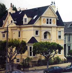 The C. A. Belden House on Gough Street is a late Revival Style home with Queen Anne and Beaux Arts features. The house is on the National Register of Historic Places in San Francisco.
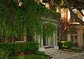 Typical house entrance in Pacific Heights.
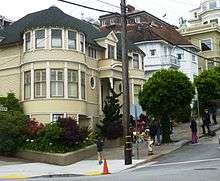 The house used for exterior shots of Mrs. Doubtfire, taken shortly after Robin Williams' death, with a fan-made tribute at its front steps.
See also
References
- 1 2 "Statewide Database". UC Regents. Retrieved December 8, 2014.
- ↑ "California's 12th Congressional District - Representatives & District Map". Civic Impulse, LLC.
- ↑ Pacific Heights neighborhood in San Francisco, California (CA), 94109, 94115, 94123 detailed profile
- ↑ "Mission Statement." Pacific Heights Residents Association. Retrieved on February 1, 2009.
- ↑ Bakalinsky, Adah (October 9, 2013). Stairway Walks in San Francisco. Wilderness Press. p. 66. ISBN 978-0-89997-637-2.
- ↑ O'Brien, Tricia (2008). San Francisco's Pacific Heights and Presidio Heights. Arcadia Publishing. p. 7. ISBN 978-0-7385-5980-3.
- ↑ Richards, Rand (2002). Historic Walks in San Francisco: 18 Trails Through the City's Past. Heritage House Publishers. p. 305. ISBN 978-1-879367-03-6.
- ↑ "Address, Contact and Office Hours." Consulate-General of Germany in San Francisco. Retrieved on January 31, 2009.
- ↑ "Consulate General San Francisco." Embassy of Greece Washington, DC. Retrieved on January 31, 2009.
- ↑ "Welcome to the web site of the Consulate General of Italy in San Francisco." Consulate-General of Italy in San Francisco. Retrieved on January 31, 2009.
- ↑ "Portugal Visa Information." United Nations. Retrieved on February 1, 2009.
- ↑ Home page. Consulate-General of Russia in San Francisco. Retrieved on January 31, 2009.
- ↑ http://www.koreaembassyusa.org/
- ↑ "Welcome to Vietnam consulate-San Francisco,USA." Consulate-General of Vietnam in San Francisco. Retrieved on January 31, 2009.
- ↑ "Academy of Art University Campus Map" (PDF). academyart.edu. Academy of Art University. Retrieved 23 November 2016.
- ↑ "Northern Station." (Archive) San Francisco Police Department. Retrieved on September 1, 2013.
- ↑ John Arlidge (March 17, 2014). "Jonathan Ive Designs Tomorrow". Time. Time Inc. Retrieved March 22, 2014.
- ↑ "Jay Paul". Forbes. Retrieved 14 September 2015.
External links
| Wikimedia Commons has media related to Pacific Heights, San Francisco. |
- phra-sf.org: Pacific Heights Residents Association
- The San Francisco Chronicle: Pacific Heights (reference article)
- The San Francisco Chronicle: "The Perfect Pacific Heights Commute, the scenes from Pacific Heights to Lucas Film in the Presidio"
- Flickr group—Pacific Heights Neighborhood (photographs pool)
 San Francisco/Golden Gate travel guide from Wikivoyage
| Downtown | .svg.png) | |
|---|---|---|
| North of Downtown | ||
| Outside Lands | ||
| Western Addition | ||
| Southern | ||
| ||
Coordinates: 37°47′30″N 122°26′08″W / 37.7917°N 122.4356°W