Osterburg Covered Bridge
|
Osterburg Covered Bridge | |
|
The bridge in October 2010 | |
  | |
| Location | West of Osterburg on Township 757, East St. Clair Township, Pennsylvania |
|---|---|
| Coordinates | 40°10′37″N 78°32′30″W / 40.17694°N 78.54167°WCoordinates: 40°10′37″N 78°32′30″W / 40.17694°N 78.54167°W |
| Area | less than one acre |
| MPS | Bedford County Covered Bridges TR |
| NRHP Reference # | 80003421[1] |
| Added to NRHP | April 10, 1980 |
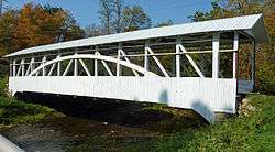
The Osterburg Covered Bridge, also known as Bowser's Covered Bridge, is a historic wooden covered bridge located at East St. Clair Township in Bedford County, Pennsylvania. It is a 90-foot-long (27 m), Burr Truss bridge with a shallow gable roof. It crosses Bobs Creek. It is one of 15 historic covered bridges in Bedford County.[2]
It was listed on the National Register of Historic Places in 1980.[1]
References
| Wikimedia Commons has media related to Osterburg Covered Bridge. |
- 1 2 National Park Service (2010-07-09). "National Register Information System". National Register of Historic Places. National Park Service.
- ↑ "National Historic Landmarks & National Register of Historic Places in Pennsylvania" (Searchable database). CRGIS: Cultural Resources Geographic Information System. Note: This includes Susan M. Zacher and Barbara Hufnagel (n.d.). "National Register of Historic Places Inventory Nomination Form: Osterburg Covered Bridge" (PDF). Retrieved 2011-11-19.
| Topics |   | |
|---|---|---|
| Lists by county |
| |
| Lists by city | ||
| Other lists | ||
| ||
This article is issued from Wikipedia - version of the 11/28/2016. The text is available under the Creative Commons Attribution/Share Alike but additional terms may apply for the media files.