Oroville, Washington
| Oroville | ||
|---|---|---|
| City | ||
| Oroville, Washington | ||
|
The townsite of Osoyoos Lake within the northern Okanogan Highlands in Oroville, Washington | ||
| ||
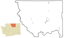 Location of Oroville in Okanogan County, Washington | ||
 Oroville Location in the United States | ||
| Coordinates: 48°56′19″N 119°26′6″W / 48.93861°N 119.43500°WCoordinates: 48°56′19″N 119°26′6″W / 48.93861°N 119.43500°W | ||
| Country | United States | |
| State | Washington | |
| County | Okanogan | |
| Established | January 1, 1892 | |
| Incorporated | August 7, 1908 | |
| Government | ||
| • Type | Mayor–council | |
| • Mayor | Chuck Spieth | |
| • Governing body | Oroville City Council | |
| Area | ||
| • Total | 1.68 sq mi (4.4 km2) | |
| • Land | 1.64 sq mi (4.2 km2) | |
| • Water | 0.04 sq mi (0.1 km2) | |
| Elevation | 938 ft (286 m) | |
| Population (2010)[1] | ||
| • Total | 1,686 | |
| • Estimate (2015)[2] | 1,677 | |
| • Density | 1,028/sq mi (396.9/km2) | |
| Time zone | PST (UTC-8) | |
| • Summer (DST) | PDT (UTC-7) | |
| ZIP codes | 98844 | |
| Area code(s) | 509 | |
| FIPS code | 53-51970[3] | |
| GNIS feature ID | 1524077[4] | |
| Website | City of Oroville | |
.jpg)
Oroville is a city located in the northern bulk of the Okanogan Highlands in north-central Washington, United States. Oroville is a member municipality of Okanogan County, Washington, situated between Omak and Penticton. The population was 1,686 at the 2010 census.
Geography
Oroville is located at 48°56′19″N 119°26′6″W / 48.93861°N 119.43500°W (48.938508, -119.434903).[5]
According to the United States Census Bureau, the city has a total area of 1.68 square miles (4.35 km2), of which, 1.64 square miles (4.25 km2) is land and 0.04 square miles (0.10 km2) is water.[6]
Oroville is located 4 miles (6.4 km) south of the Canada–US border, and features an official crossing into Osoyoos, British Columbia.
Climate
This climatic region is typified by large seasonal temperature differences, with warm to hot summers and cold (sometimes severely cold) winters. According to the Köppen climate classification system, Oroville has a humid continental climate, Dfb on climate maps.[7]
Demographics
| Historical population | |||
|---|---|---|---|
| Census | Pop. | %± | |
| 1910 | 495 | — | |
| 1920 | 1,013 | 104.6% | |
| 1930 | 800 | −21.0% | |
| 1940 | 1,206 | 50.8% | |
| 1950 | 1,500 | 24.4% | |
| 1960 | 1,437 | −4.2% | |
| 1970 | 1,555 | 8.2% | |
| 1980 | 1,483 | −4.6% | |
| 1990 | 1,505 | 1.5% | |
| 2000 | 1,653 | 9.8% | |
| 2010 | 1,686 | 2.0% | |
| Est. 2015 | 1,677 | [8] | −0.5% |
| U.S. Decennial Census[9] 2015 Estimate[2] | |||
2010 census
As of the census[1] of 2010, there were 1,686 people, 698 households, and 434 families residing in the city. The population density was 1,028.0 inhabitants per square mile (396.9/km2). There were 797 housing units at an average density of 486.0 per square mile (187.6/km2). The racial makeup of the city was 78.8% White, 0.8% African American, 2.4% Native American, 1.1% Asian, 0.1% Pacific Islander, 12.7% from other races, and 4.2% from two or more races. Hispanic or Latino of any race were 21.4% of the population.
There were 698 households of which 33.1% had children under the age of 18 living with them, 45.6% were married couples living together, 10.7% had a female householder with no husband present, 5.9% had a male householder with no wife present, and 37.8% were non-families. 32.1% of all households were made up of individuals and 16.3% had someone living alone who was 65 years of age or older. The average household size was 2.41 and the average family size was 3.03.
The median age in the city was 39.4 years. 26.2% of residents were under the age of 18; 7.5% were between the ages of 18 and 24; 23.3% were from 25 to 44; 26.2% were from 45 to 64; and 16.7% were 65 years of age or older. The gender makeup of the city was 49.2% male and 50.8% female.
2000 census
As of the census of 2000, there were 1,653 people, 691 households, and 433 families residing in the town. The population density was 1,336.5 people per square mile (514.7/km²). There were 794 housing units at an average density of 642.0 per square mile (247.2/km²). The racial makeup of the town was 82.34% White, 0.12% African American, 4.23% Native American, 0.30% Asian, 0.30% Pacific Islander, 9.32% from other races, and 3.39% from two or more races. Hispanic or Latino of any race were 17.06% of the population.
There were 691 households out of which 32.1% had children under the age of 18 living with them, 45.6% were married couples living together, 13.3% had a female householder with no husband present, and 37.2% were non-families. 32.0% of all households were made up of individuals and 14.5% had someone living alone who was 65 years of age or older. The average household size was 2.37 and the average family size was 2.99.
In the town, the population was spread out with 28.9% under the age of 18, 5.1% from 18 to 24, 25.6% from 25 to 44, 23.7% from 45 to 64, and 16.7% who were 65 years of age or older. The median age was 38 years. For every 100 females there were 94.0 males. For every 100 females age 18 and over, there were 88.3 males.
The median income for a household in the town was $22,301, and the median income for a family was $30,114. Males had a median income of $25,833 versus $21,750 for females. The per capita income for the town was $12,220. About 22.6% of families and 28.9% of the population were below the poverty line, including 37.0% of those under age 18 and 19.5% of those age 65 or over.
Economy
Most of the economy of Oroville and the surrounding areas is based on agriculture. Numerous orchards and a few grape vineyards are within the town limits. During Oroville's heyday as a mining town, many saloons, restaurants, shops, and a drive-in movie theater were there.[10] Today, the town's economy is depressed with a nearly 30% poverty rate and a median household income of only $22,000. Recently, three vacation cottage developments have been built, two east of Lake Osoyoos, Sandalia, and the Veranda Beach Resort, and one just north of downtown, Sonora Shores.
History
Oroville was first settled by caucasian settlers in the late 1850s and known as 'rag town'. The settlement was named Oro, after the Spanish word for gold, in 1892 after the surrounding gold mines, and in an attempt to attract prospectors and merchants. The Post Office objected to the name "Oro" because a town was already named "that" in Washington, so the name was changed to Oroville,[11] in 1909. Oroville started to become a tourist location; in the mid-2000s, large condo developments were proposed. The city had an economy peak in 2005-2007, but has continued suffering since to the 'great recession'. It is home to the Dorothy Scott Airport, a municipal airport located 2 mi outside of the town center that was opened in August 1937.[12][13]
Crime
| Oroville | |
| Crime rates (2012) | |
| Crime type | Rate* |
|---|---|
| Homicide: | 0 |
| Robbery: | 0 |
| Aggravated assault: | 1 |
| Total violent crime: | 2 |
| Burglary: | 20 |
| Larceny-theft: | 57 |
| Motor vehicle theft: | 1 |
| Arson: | 0 |
| Total property crime: | 78 |
| Notes * Number of reported crimes per 100,000 population. 2012 population: 1,715 |
|
| Source: 2012 FBI UCR Data | |
According to the Uniform Crime Report statistics compiled by the Federal Bureau of Investigation in 2012, two violent crimes and 78 property crimes per 100,000 residents occur per year. Of these, the violent crimes consisted of one forcible rape, no robberies, and one aggravated assault, while 20 burglaries, 57 larceny-thefts, one motor vehicle theft, and no arson defined the property offenses.[14]
References
- 1 2 "American FactFinder". United States Census Bureau. Retrieved 2012-12-19.
- 1 2 "Population Estimates". United States Census Bureau. Retrieved July 12, 2016.
- ↑ "American FactFinder". United States Census Bureau. 2013. Retrieved May 14, 2011.
- ↑ "Oroville". Geographic Names Information System. United States Geological Survey.
- ↑ "US Gazetteer files: 2010, 2000, and 1990". United States Census Bureau. 2011-02-12. Retrieved 2011-04-23.
- ↑ "US Gazetteer files 2010". United States Census Bureau. Retrieved 2012-12-19.
- ↑ Climate Summary for Oroville, Washington
- ↑ "Annual Estimates of the Resident Population for Incorporated Places: April 1, 2010 to July 1, 2015". Retrieved July 2, 2016.
- ↑ United States Census Bureau. "Census of Population and Housing". Retrieved October 4, 2013.
- ↑ http://www.drive-ins.com/theater/watorov
- ↑ Gulick, Bill. A Traveler's History of Washington. Caxton Press, 1996. ISBN 0-87004-371-4. p. 340
- ↑ "Airport Identification Information". Washington. Retrieved November 17, 2012.
- ↑ "Washington Offenses Known to Law Enforcement by City, 2012". Federal Bureau of Investigation. 2012. Retrieved October 4, 2013.
External links
Municipalities and communities of Okanogan County, Washington, United States | ||
|---|---|---|
| Cities | 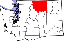 | |
| Towns | ||
| CDPs | ||
| Unincorporated communities | ||
| Indian reservation | ||
| Ghost towns | ||
| Footnotes | ‡This populated place also has portions in an adjacent county or counties | |