Oregon Route 19
| ||||
|---|---|---|---|---|
 | ||||
| Route information | ||||
| Maintained by ODOT | ||||
| Length: | 120.57 mi[1] (194.04 km) | |||
| Existed: | 1932 – present | |||
| Component highways: | John Day Highway No. 5 | |||
| Major junctions | ||||
| South end: |
| |||
| ||||
| North end: |
| |||
| Location | ||||
| Counties: | Grant, Wheeler, Gilliam | |||
| Highway system | ||||
| ||||

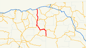
Oregon Route 19 (OR 19) is a state highway in the north-central part of the U.S. state of Oregon. It runs from a junction with U.S. Route 26 in Grant County, near the Sheep Rock Unit of the John Day Fossil Beds National Monument to Interstate 84 at Arlington in the Columbia River Gorge. OR 19 traverses the northern portion of the John Day Highway No. 5 of the Oregon state highway system[2] and follows the John Day River from the southern terminus to Service Creek. The route has two brief overlaps with Oregon Route 206 and Oregon Route 207, both on the portions of those routes included in the Wasco-Heppner Highway No. 300.
Major intersections
Milepoints are as reported by ODOT and do not necessarily reflect current mileage. Z indicates overlapping mileage due to construction longer than established route, and – indicates negative mileage behind established beginning point.[3] For routes traversing multiple named state highways, each milepoint is preceded by the corresponding state highway number.
| County | Location[1] | Milepoint[1] | Destinations | Notes | |
|---|---|---|---|---|---|
| Grant | | 124.17 | |||
| | 119.46 | John Day River | |||
| | 107.16 | Viewpoint | |||
| | 105.60 | North Fork John Day River | |||
| Kimberly | 105.23 | ||||
| Wheeler | | 95.56 | Southern end of concurrency with OR 207 | ||
| Service Creek | 78.56 | Northern end of concurrency with OR 207 | |||
| | 68.18 | Butte Creek Pass Summit, elevation 3,788 feet (1,155 m) | |||
| Fossil | 58.15 | ||||
| | 53.80 | Cummings Hill Summit, elevation 3,310 feet (1,010 m) | |||
| Gilliam | Condon | 38.27 | Southern end of concurrency with OR 206 | ||
| 38.07 | Northern end of concurrency with OR 206 | ||||
| | 7.96 | Oregon Trail Viewpoint historical marker | |||
| Arlington | 0.00 | Exit 137 on I-84 | |||
1.000 mi = 1.609 km; 1.000 km = 0.621 mi
| |||||
References
- 1 2 3 Road Inventory and Classification Services Unit. "Straightline Charts". Transportation Development Division, Oregon Department of Transportation. Retrieved September 6, 2015.
- John Day Highway No. 5 (April 2015)
- ↑ Road Inventory and Classification Services Unit. "2012 Cross Reference Table of Highway Route Number to State Highway Number" (PDF). Transportation Development Division, Oregon Department of Transportation. Retrieved September 6, 2015.
- ↑ Road Inventory and Classification Services Unit. "Straightline Chart Legend" (PDF). Transportation Development Division, Oregon Department of Transportation. Retrieved August 29, 2015.