John Day River
| John Day River | |
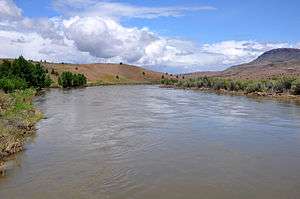 John Day River at Clarno | |
| Name origin: John Day, a hunter and fur trapper[1] | |
| Country | United States |
|---|---|
| State | Oregon |
| Tributaries | |
| - left | South Fork John Day River |
| - right | North Fork John Day River |
| Source | Strawberry Mountains |
| - location | Malheur National Forest, Grant County |
| - elevation | 6,681 ft (2,036 m) [2] |
| - coordinates | 44°14′44″N 118°33′08″W / 44.245439°N 118.5521617°W [3] |
| Mouth | Columbia River |
| - elevation | 268 ft (82 m) [2] |
| - coordinates | 45°43′57″N 120°38′57″W / 45.7326252°N 120.6492244°WCoordinates: 45°43′57″N 120°38′57″W / 45.7326252°N 120.6492244°W [3] |
| Length | 284 mi (457 km) [4][5] |
| Basin | 8,000 sq mi (20,720 km2) [5] |
| Discharge | for USGS gage 14048000, McDonald Ferry, river mile 20.9, 45°35′16″N 120°24′30″W / 45.587778°N 120.408333°W |
| - average | 2,075 cu ft/s (59 m3/s) [6] |
| - max | 43,300 cu ft/s (1,226 m3/s) |
| - min | 0 cu ft/s (0 m3/s) |
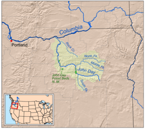 Map of the John Day watershed | |
| Wikimedia Commons: John Day River | |

The John Day River is a tributary of the Columbia River, approximately 284 miles (457 km) long, in northeastern Oregon in the United States. Undammed along its entire length, the river is the third longest free-flowing river in the contiguous United States. There is extensive use of its waters for irrigation. Its course furnishes habitat for diverse species, including wild steelhead and Chinook salmon runs.[4][7] However, the steelhead populations are under federal Endangered Species Act (ESA) protections, and the Chinook salmon have been proposed for such protection.
The river was named for John Day, a member of the Astor Expedition, an overland expedition to the mouth of the Columbia River that left from St. Louis, Missouri, in 1810. Day wandered lost through this part of Oregon in the winter of 1811–1812.[1]
The absence of dams on the river causes its flow to greatly fluctuate throughout the year depending on snowpack and rainfall within the watershed.[8] The highest flow recorded at a gauge on the lower John Day was 43,300 cubic feet per second (1,230 m3/s) on January 2, 1997. The lowest flow was no flow at all, which occurred on September 2, 1966; from August 15 to September 16, 1973; and on nine days in August 1977. The average flow at the gauge is 2,075 cubic feet per second (58.8 m3/s).[6]
Drainage basin
Through its tributaries, the river drains much of the western side of the Blue Mountains, flowing across the sparsely populated arid part of the state east of the Cascade Range in a northwest zigzag, then entering the Columbia upstream from the Columbia River Gorge. It flows through exceptionally scenic canyons in its upper course, with several significant paleontological sites along its banks.[5][9] Elevations within the watershed range from 268 feet (82 m) at the river's mouth to more than 9,000 feet (2,700 m) in the Strawberry Mountains.[2][10]
The main branch of the John Day River rises in the Strawberry Mountains in eastern Grant County.[11] The North Fork heads on the western slope of the Elkhorn Mountains in northeastern Grant County.[12] The Middle Fork rises near the crest of the Blue Mountains on the eastern edge of Grant County. The South Fork's source is in northern Harney County, about 10 miles (16 km) south of the Grant County line. The main, south and middle forks each have their heads in different parts of the Malheur National Forest, while the North Fork's source is located within in the Wallowa-Whitman National Forest. The main fork flows initially north, then west through the John Day Valley and through the cities of Prairie City, John Day and Mount Vernon. At Dayville, in western Grant County, it is joined from the south by the South Fork John Day River, then flows north through Picture Gorge and the Sheep Rock Unit of the John Day Fossil Beds National Monument.
At Kimberly in northwestern Grant County, it is joined from the east by the North Fork John Day River (which had already joined with the Middle Fork John Day River above Monument, Grant County, Oregon). The river then flows west across Wheeler County. At the county line with Jefferson County it flows north, past the Clarno Unit of the John Day Fossil Beds National Monument. As it approaches the Columbia River in north-central Oregon it flows in an increasingly meandering course, forming the boundary between Sherman County to the west and Gilliam County to the east.
The John Day River joins the Columbia from the southeast approximately 16 miles (26 km) northeast of Biggs. The mouth of the river is on the narrow Lake Umatilla reservoir, formed on the Columbia by the John Day Dam, approximately 2 miles (3.2 km) downstream from the mouth of the John Day.
Recreation and ecosystem
The John Day is navigable by rafts and other small river craft by boaters who obtain permits provided by the BLM.[10] Its lower course is used for irrigation of cropland and ranching.[4] In 1988, the United States Congress designated 147.5 miles (237.4 km) of the river from Service Creek to Tumwater Falls as Wild and Scenic for its recreational opportunities. The segment of the river is a popular destination for anadromous steelhead and warm water bass fishing, as well as whitewater rafting.[13]
In addition to wild spring chinook salmon and bass, the river furnishes habitat for Columbia River redband trout, bull trout, and westslope cutthroat trout.[7][14] There are no hatchery salmon or steelhead released in the John Day River.
See also
- List of rivers of Oregon
- List of longest streams of Oregon
- List of National Wild and Scenic Rivers
- Lost Blue Bucket Mine, a lost mine believed to be somewhere on the John Day
References
- 1 2 Topinka, Lyn. "John Day River, Oregon". Columbia River Images. Retrieved July 6, 2013.
- 1 2 3 Source and mouth elevations derived from Google Earth using GNIS coordinates.
- 1 2 "John Day River". Geographic Names Information System. United States Geological Survey. November 28, 1980. Retrieved July 6, 2013.
- 1 2 3 "John Day River". Oregon Environmental Council. Retrieved July 6, 2013.
- 1 2 3 "John Day Subbasin Plan", p. 18
- 1 2 "Water-Data Report 2012: 14048000 John Day River at McDonald Ferry, OR" (PDF). U.S. Geological Survey. Retrieved July 6, 2013.
- 1 2 "John Day Subbasin Plan", p. 31
- ↑ "John Day River: Boating General Information". Bureau of Land Management. Retrieved July 6, 2013.
- ↑ "John Day Subbasin Plan", p. 201
- 1 2 "John Day River". Bureau of Land Management. Retrieved July 6, 2013.
- ↑ United States Geological Survey. "United States Geological Survey Topographic Map: Roberts Creek quadrant". TopoQuest. Retrieved August 3, 2013.
- ↑ United States Geological Survey. "United States Geological Survey Topographic Map: Bourne quadrant". TopoQuest. Retrieved August 3, 2013.
- ↑ "John Day River, Oregon". National Wild and Scenic Rivers System. Retrieved July 6, 2013.
- ↑ "John Day Subbasin Plan", p. 52
Works cited
- Columbia-Blue Mountain Resource Conservation & Development Area (March 15, 2005). "John Day Subbasin Plan: Revised Draft Plan" (PDF). Northwest Power and Conservation Council. Retrieved July 6, 2013.
External links
| Wikimedia Commons has media related to John Day River. |