Condon, Oregon
| Condon, Oregon | |
|---|---|
| City | |
|
Condon City Hall | |
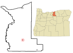 Location in Oregon | |
| Coordinates: 45°14′8″N 120°11′6″W / 45.23556°N 120.18500°WCoordinates: 45°14′8″N 120°11′6″W / 45.23556°N 120.18500°W | |
| Country | United States |
| State | Oregon |
| County | Gilliam |
| Incorporated | 1893 |
| Government | |
| • Mayor | Jim Hassing[1] |
| Area[2] | |
| • Total | 0.83 sq mi (2.15 km2) |
| • Land | 0.83 sq mi (2.15 km2) |
| • Water | 0 sq mi (0 km2) |
| Elevation | 2,831 ft (863 m) |
| Population (2010)[3] | |
| • Total | 682 |
| • Estimate (2012[4]) | 712 |
| • Density | 821.7/sq mi (317.3/km2) |
| Time zone | Pacific (UTC-8) |
| • Summer (DST) | Pacific (UTC-7) |
| ZIP code | 97823 |
| Area code(s) | 458 and 541 |
| FIPS code | 41-15000[3] |
| GNIS feature ID | 1119195[5] |
| Website | |
|
Condon Commercial Historic District | |
|
The IOOF Hall, J.F. Reisacher Building, and Bank Block (left to right) in 2012. | |
| Location | Downtown Condon, Oregon |
| Area | 9.95 acres (4.03 ha) |
| NRHP Reference # |
98000609 (original) 01000493 (increase) |
| Significant dates | |
| Added to NRHP | May 29, 1998 |
| Boundary increase | May 16, 2001 |
_(gilD0088a).jpg)

Condon is a city in, and the county seat of, Gilliam County, in the U.S. state of Oregon.[6] The population was 682 at the 2010 census.[7] The city, with an historic main street along Oregon Route 19, is a farming and ranching community.
History
Condon was the southern terminus of the Condon Branch of the Union Pacific Railroad.[8] In 1883, a local homesteader named Potter platted the land around a spring on his property.[8] The spring, which emerged from a bed of black basalt, was known to pioneer ranchers in the area as Summit Springs.[9] Experiencing financial difficulty, Potter surrendered the site to the legal firm Condon and Cornish from Arlington.[8] Harvey C. Condon, a member of the firm, was a nephew of Oregon geologist Thomas Condon.[8] Condon and Cornish sold lots in the townsite and in 1884, resident David B. Trimble applied for a post office and became its first postmaster.[8] He named the post office Condon after Harvey C. Condon.[8]
Condon Air Force Station was a radar station near the city[8] that operated from 1951 to 1970.
Condon Commercial Historic District
In 1998, Condon's historic downtown core along Main Street was listed on the National Register of Historic Places as the Condon Commercial Historic District.[10] The City of Condon is collaborating with business interests to "spruce up" buildings on Main Street.[11] Most of the businesses on the Historic Main Street have been restored, new businesses have opened, a new library has been built, the City Park has been re-designed and the Chamber of Commerce is growing.
Geography and climate
Condon, in Gilliam County in north-central Oregon, is at the intersection of Oregon Route 19, running north–south through the city, and Oregon Route 206, which runs east–west at Condon.[12] By highway, the city is 38 miles (61 km) south of Interstate 84 at Arlington, 69 miles (111 km) southeast of The Dalles, and 150 miles (240 km) east of Portland.[13]
The city is 2,831 feet (863 m) above sea level.[5] According to the United States Census Bureau, the city has a total area of 0.83 square miles (2.15 km2), all of it land.[2]
| Climate data for Condon, Oregon (1981–2010) | |||||||||||||
|---|---|---|---|---|---|---|---|---|---|---|---|---|---|
| Month | Jan | Feb | Mar | Apr | May | Jun | Jul | Aug | Sep | Oct | Nov | Dec | Year |
| Average high °F (°C) | 39.1 (3.9) |
43.2 (6.2) |
51.0 (10.6) |
57.4 (14.1) |
65.5 (18.6) |
72.8 (22.7) |
82.6 (28.1) |
82.1 (27.8) |
73.2 (22.9) |
60.8 (16) |
46.3 (7.9) |
37.3 (2.9) |
59.3 (15.2) |
| Average low °F (°C) | 25.1 (−3.8) |
26.4 (−3.1) |
30.4 (−0.9) |
33.8 (1) |
39.9 (4.4) |
45.2 (7.3) |
50.7 (10.4) |
50.3 (10.2) |
43.8 (6.6) |
35.8 (2.1) |
29.4 (−1.4) |
23.1 (−4.9) |
36.2 (2.3) |
| Average precipitation inches (mm) | 1.63 (41.4) |
1.25 (31.8) |
1.28 (32.5) |
1.38 (35.1) |
1.60 (40.6) |
1.08 (27.4) |
0.46 (11.7) |
0.43 (10.9) |
0.57 (14.5) |
1.08 (27.4) |
1.69 (42.9) |
1.78 (45.2) |
14.21 (360.9) |
| Average snowfall inches (cm) | 5.8 (14.7) |
5.1 (13) |
2.0 (5.1) |
0.8 (2) |
0.0 (0) |
0.0 (0) |
0.0 (0) |
0.0 (0) |
0.0 (0) |
0.4 (1) |
3.0 (7.6) |
7.2 (18.3) |
24.2 (61.5) |
| Source: NOAA[14] | |||||||||||||
Demographics
| Historical population | |||
|---|---|---|---|
| Census | Pop. | %± | |
| 1890 | 60 | — | |
| 1900 | 230 | 283.3% | |
| 1910 | 1,009 | 338.7% | |
| 1920 | 1,127 | 11.7% | |
| 1930 | 940 | −16.6% | |
| 1940 | 856 | −8.9% | |
| 1950 | 968 | 13.1% | |
| 1960 | 1,149 | 18.7% | |
| 1970 | 973 | −15.3% | |
| 1980 | 783 | −19.5% | |
| 1990 | 635 | −18.9% | |
| 2000 | 759 | 19.5% | |
| 2010 | 682 | −10.1% | |
| Est. 2015 | 681 | [15] | −0.1% |
| source:[3][16] | |||
2010 census
As of the census of 2010, there were 682 people, 357 households, and 184 families residing in the city. The population density was 821.7 inhabitants per square mile (317.3/km2). There were 455 housing units at an average density of 548.2 per square mile (211.7/km2). The racial makeup of the city was 97.2% White, 0.1% African American, 0.9% Native American, 0.1% Asian, 0.9% from other races, and 0.7% from two or more races. Hispanic or Latino of any race were 2.1% of the population.[3]
There were 357 households of which 16.2% had children under the age of 18 living with them, 42.3% were married couples living together, 5.6% had a female householder with no husband present, 3.6% had a male householder with no wife present, and 48.5% were not families. 45.9% of all households were made up of individuals and 24.9% had someone living alone who was 65 years of age or older. The average household size was 1.85 and the average family size was 2.54.[3]
The median age in the city was 54.5 years. 14.7% of residents were under the age of 18; 3.7% were between the ages of 18 and 24; 15.4% were from 25 to 44; 34.7% were from 45 to 64; and 31.7% were 65 years of age or older. The gender makeup of the city was 46.6% male and 53.4% female.[3]
2000 census
As of the census of 2000, there were 759 people, 343 households, and 215 families residing in the city. The population density was 887.3 people per square mile (340.8/km²). There were 413 housing units at an average density of 482.8 per square mile (185.4/km²). The racial makeup of the city was 97.50% White, 0.40% African American, 0.79% Native American, 0.26% Asian, 0.13% from other races, and 0.92% from two or more races. Hispanic or Latino of any race were 0.53% of the population.[3]
There were 343 households out of which 22.2% had children under the age of 18 living with them, 53.9% were married couples living together, 6.7% had a female householder with no husband present, and 37.3% were non-families. 34.4% of all households were made up of individuals and 17.8% had someone living alone who was 65 years of age or older. The average household size was 2.14 and the average family size was 2.72.[3]
In the city the population was spread out with 19.6% under the age of 18, 4.0% from 18 to 24, 21.9% from 25 to 44, 26.6% from 45 to 64, and 27.9% who were 65 years of age or older. The median age was 48 years. For every 100 females there were 95.1 males. For every 100 females age 18 and over, there were 88.3 males.[3]
The median income for a household in the city was $32,667, and the median income for a family was $40,000. Males had a median income of $30,500 versus $21,042 for females. The per capita income for the city was $18,481. About 3.6% of families and 5.4% of the population were below the poverty line, including 5.1% of those under age 18 and 5.1% of those age 65 or over.[3]
Arts and culture
Condon hosts special events throughout the year including Robert Burns Day in January, the Tumbleweed Basketball Tournament in March, the Fabulous 4th of July, and the Fall Festival in November.[17]
The Gilliam County Historical Museum complex at Burns Park along Route 19 includes several restored buildings, including a train depot, caboose, church, barber shop, jail, school house, and the Silas A. Rice Log House, which is listed on the National Register of Historic Places.[18]
Condon has a farmers market, golf course, swimming pool, and movie theater, and a game-bird reserve and recreational ranches are nearby.[19]
Education and economy
Condon students are served by the Condon School District, which includes Condon Elementary School and Condon High School.
The five largest employers in Condon as of 2002 were the Gilliam County government, the Condon School District, the North-Central Education Service District, the Hotel Condon, and Summit Springs Village, an assisted living center.[13]
Media
The Times-Journal is a weekly newspaper published in Condon.[20]
Transportation
The state airport in Condon is named Pauling Field after former resident Linus Pauling.
Notable people
- Jay Bowerman, 13th governor of Oregon
- John Burns, Oregon Senate President from 1971 to 1973
- Robert R. Butler, U.S. representative from Oregon
- Terry Cooney, Major League Baseball umpire
- William Parry Murphy, Nobel laureate (1934 Medicine)[21]
- Linus Pauling, Nobel laureate (1954 Chemistry and 1962 Peace)
- Earl Snell, 23rd governor of Oregon
References
- ↑ "Incorporated Cities: Condon". Oregon Blue Book. Oregon Secretary of State. 2013. Retrieved January 10, 2015.
- 1 2 "U.S. Gazetteer: 2010, 2000, and 1990". United States Census Bureau. Retrieved 2013-08-17.
- 1 2 3 4 5 6 7 8 9 10 "American FactFinder". U.S. Census Bureau. Archived from the original on 2014-12-10. Retrieved 2013-08-17.
- ↑ "Population Estimates". United States Census Bureau. Archived from the original on 2013-06-17. Retrieved 2013-06-02.
- 1 2 "Condon". Geographic Names Information System. United States Geological Survey. November 28, 1980. Retrieved 2013-08-17.
- ↑ "Find a County". National Association of Counties. Archived from the original on 2011-05-31. Retrieved 2011-06-07.
- ↑ "2010 Census data: Oregon cities alphabetically A-C" (PDF). Portland State University Population Research Center. Retrieved 2011-12-27.
- 1 2 3 4 5 6 7 McArthur, Lewis A.; McArthur, Lewis L. (2003) [1928]. Oregon Geographic Names (7th ed.). Portland, Oregon: Oregon Historical Society Press. p. 224. ISBN 978-0875952772.
- ↑ Shaver, F. A.; et al. (1905). An Illustrated History of Central Oregon Embracing Wasco, Sherman, Gilliam, Wheeler, Crook, Lake and Klamath Counties. Spokane, Washington: Western Publishing Co. pp. 568–71. OCLC 5436491.
- ↑ Donovan, Sally (July 1997). "National Register of Historic Places Registration Form: Condon Commercial Historic District" (PDF). National Park Service. Retrieved 2012-08-12.
- ↑ "Welcome to the City of Condon". City of Condon. 2013. Retrieved 2013-08-17.
- ↑ Oregon Atlas & Gazetteer (7th ed.). Yarmouth, Maine: DeLorme. 2008. p. 72. ISBN 978-0-89933-347-2.
- 1 2 Infrastructure Finance Authority (2009). "Condon Community Profile". Business Oregon. Retrieved 2013-08-17.
- ↑ "NOWData - NOAA Online Weather Data". National Oceanic and Atmospheric Administration. Retrieved 2013-05-05.
- ↑ "Annual Estimates of the Resident Population for Incorporated Places: April 1, 2010 to July 1, 2015". Retrieved July 2, 2016.
- ↑ Moffatt, Riley Moore (1996). Population History of Western U.S. Cities and Towns, 1850–1990. Lanham, Maryland: Scarecrow Press. p. 208. ISBN 978-0-8108-3033-2.
- ↑ "Special Events". Condon Chamber of Commerce. Retrieved 2013-08-17.
- ↑ "Gilliam County Historical Society". Condon Chamber of Commerce. Retrieved 2013-08-17.
- ↑ "Activities". Condon Chamber of Commerce. Retrieved 2013-08-17.
- ↑ "The Times Journal". Condon Chamber of Commerce. Retrieved 2013-08-17.
- ↑ "Gilliam County, Oregon Genealogy & History". Retrieved 2011-10-27.
External links
Municipalities and communities of Gilliam County, Oregon, United States | ||
|---|---|---|
| Cities | 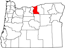 | |
| Unincorporated communities | ||
| Former communities | ||