Antelope, Oregon
| Antelope, Oregon | |
|---|---|
| City | |
|
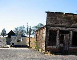
Post office and abandoned building in Antelope | |
 Location in Oregon | |
| Coordinates: 44°54′39″N 120°43′22″W / 44.91083°N 120.72278°WCoordinates: 44°54′39″N 120°43′22″W / 44.91083°N 120.72278°W | |
| Country | United States |
| State | Oregon |
| County | Wasco |
| Incorporated | 1901 |
| Government | |
| • Mayor | Acting Mayor - City Council President Larry Smith |
| Area[1] | |
| • Total | 0.48 sq mi (1.24 km2) |
| • Land | 0.48 sq mi (1.24 km2) |
| • Water | 0 sq mi (0 km2) |
| Elevation | 2,654 ft (809 m) |
| Population (2010)[2] | |
| • Total | 46 |
| • Estimate (2012[3]) | 47 |
| • Density | 95.8/sq mi (37.0/km2) |
| Time zone | Pacific (UTC-8) |
| • Summer (DST) | Pacific (UTC-7) |
| ZIP code | 97001 |
| Area code(s) | 541 |
| FIPS code | 41-02250[2] |
| GNIS feature ID | 1116966[4] |
| Website | cityofantelope.us |
Antelope is a city in Wasco County, Oregon, United States. It was briefly named Rajneesh in the mid-1980s when followers of Bhagwan Shree Rajneesh moved into the city from nearby Rajneeshpuram and voted for the name change. As of the 2010 Census, the population was 46.[2]
History
Antelope Valley was probably named by members of Joseph Sherar's party who were packing supplies to mines in the John Day area.[5] Sherar became known as the operator of a toll bridge across the Deschutes River, on a cut-off of the Barlow Road.[6] There were many pronghorns (often called pronghorn antelope) in the area in the early 19th century.[5]
_(wascDA0063).jpg)
In the mid-19th century, Antelope was along the wagon road connecting The Dalles on the Columbia River with gold mines near Canyon City. After about 1870, the wagon road became known as The Dalles Military Road.[7] The road crossed the Deschutes River on Sherar's Bridge.[8]
Antelope post office was established in 1871, with Howard Maupin, founder of Maupin, Oregon, as the first postmaster.[5] The town's population peaked around 1900,[9] shortly after the Columbia Southern Railway completed a 70-mile (110 km) rail line from Biggs, on the Columbia River, to Shaniko, a few miles north of Antelope.[10] The railroad timetable for September 9, 1900, lists a daily stagecoach run from the train terminal in Shaniko to Antelope and beyond.[10] Antelope was incorporated by the Oregon Legislative Assembly on January 29, 1901.[11]
In the 1980s the town grew again when followers of Bhagwan Shree Rajneesh, who had started the city of Rajneeshpuram on the nearby "Big Muddy Ranch", began to move in.[5] Rajneeshpuram was an intentional community (or commune) of Rajneeshees. On September 18, 1984, Antelope's charter was amended by a vote of 57 to 22 to change the name of the city to Rajneesh.[5] In November, Rajneesh, who had originally pleaded innocent to charges of immigration fraud, changed his plea to guilty and was allowed to leave the United States under the terms of a plea bargain.[12]
On November 6, 1985, the remaining residents, both original and Rajneeshee, voted 34 to 0 to restore the original name, which was never changed by the Postal Service[5] but had been changed and was subsequently restored by the United States Board on Geographic Names.[4] The ranch, 18 miles (29 km) from Antelope,[13] is now owned by Young Life and has been converted into a camp known as "Washington Family Ranch."[14]
Geography
Antelope, in Wasco County in north-central Oregon, is along Oregon Route 218 just north of its intersection with Oregon Route 293.[15] By highway, the city is 34 miles (55 km) northeast of Madras and 143 miles (230 km) east of Portland.[16] Antelope Creek, in the Deschutes River watershed, flows by Antelope.[15]
The city is at an elevation of 2,654 feet (809 m) above sea level.[4] According to the United States Census Bureau, the city has a total area of 0.48 square miles (1.24 km2), all of it land.[1]
Climate
According to the Köppen climate classification system, Antelope has a warm-summer Mediterranean climate (Köppen Csb).
| Climate data for Antelope | |||||||||||||
|---|---|---|---|---|---|---|---|---|---|---|---|---|---|
| Month | Jan | Feb | Mar | Apr | May | Jun | Jul | Aug | Sep | Oct | Nov | Dec | Year |
| Record high °F (°C) | 65 (18) |
72 (22) |
78 (26) |
90 (32) |
98 (37) |
103 (39) |
107 (42) |
109 (43) |
105 (41) |
91 (33) |
76 (24) |
72 (22) |
109 (43) |
| Average high °F (°C) | 40 (4) |
45.3 (7.4) |
52 (11) |
59.1 (15.1) |
67.2 (19.6) |
75.3 (24.1) |
85.6 (29.8) |
84.5 (29.2) |
76.1 (24.5) |
63.9 (17.7) |
49.4 (9.7) |
41.4 (5.2) |
61.6 (16.4) |
| Average low °F (°C) | 23.3 (−4.8) |
26.3 (−3.2) |
29.4 (−1.4) |
32.7 (0.4) |
38.1 (3.4) |
44.2 (6.8) |
49.7 (9.8) |
49 (9) |
42.8 (6) |
35.5 (1.9) |
29.1 (−1.6) |
24.7 (−4.1) |
35.4 (1.9) |
| Record low °F (°C) | −27 (−33) |
−22 (−30) |
5 (−15) |
11 (−12) |
10 (−12) |
12 (−11) |
29 (−2) |
30 (−1) |
20 (−7) |
8 (−13) |
−7 (−22) |
−20 (−29) |
−27 (−33) |
| Average precipitation inches (mm) | 1.59 (40.4) |
1.14 (29) |
1.13 (28.7) |
1.03 (26.2) |
1.39 (35.3) |
1.05 (26.7) |
0.33 (8.4) |
0.49 (12.4) |
0.66 (16.8) |
0.97 (24.6) |
1.65 (41.9) |
1.71 (43.4) |
13.14 (333.8) |
| Average snowfall inches (cm) | 7.1 (18) |
3.3 (8.4) |
2.2 (5.6) |
1.1 (2.8) |
0.1 (0.3) |
0 (0) |
0 (0) |
0 (0) |
0.1 (0.3) |
0.1 (0.3) |
1.8 (4.6) |
5.2 (13.2) |
21.1 (53.6) |
| Average precipitation days | 11 | 9 | 10 | 8 | 8 | 6 | 2 | 3 | 4 | 6 | 11 | 11 | 89 |
| Source: [17] | |||||||||||||
Demographics
| Historical population | |||
|---|---|---|---|
| Census | Pop. | %± | |
| 1890 | 184 | — | |
| 1900 | 249 | 35.3% | |
| 1910 | 175 | −29.7% | |
| 1920 | 199 | 13.7% | |
| 1930 | 136 | −31.7% | |
| 1940 | 90 | −33.8% | |
| 1950 | 60 | −33.3% | |
| 1960 | 46 | −23.3% | |
| 1970 | 51 | 10.9% | |
| 1980 | 39 | −23.5% | |
| 1990 | 34 | −12.8% | |
| 2000 | 59 | 73.5% | |
| 2010 | 46 | −22.0% | |
| Est. 2015 | 47 | [18] | 2.2% |
| source:[2][9] | |||
2010 census
As of the census of 2010, there were 46 people, 28 households, and 10 families residing in the city. The population density was about 96 inhabitants per square mile (37.1/km2). There were 43 housing units at an average density of about 90 per square mile (34.7/km2). The racial makeup of the city was 91.3% White, 2.2% Native American, 2.2% Asian, and 4.3% from two or more races.[2]
There were 28 households of which about 11% had children under the age of 18 living with them, about 21% were married couples living together, about 4% had a female householder with no husband present, about 11% had a male householder with no wife present, and about 64% were non-families. About 61% of all households were made up of individuals and 46.5% had someone living alone who was 65 years of age or older. The average household size was 1.64 and the average family size was 2.70.[2]
The median age in the city was 62 years. About 15% of residents were under the age of 18; about 2% were between the ages of 18 and 24; about 11% were from 25 to 44; 30.3% were from 45 to 64; and about 41% were 65 years of age or older. The gender makeup of the city was about 52% male and 48% female.[2]
.jpg)
Footnotes
- 1 2 "U.S. Gazetteer: 2010, 2000, and 1990". United States Census Bureau. Retrieved August 10, 2013.
- 1 2 3 4 5 6 7 "American FactFinder". U.S. Census Bureau. Archived from the original on December 10, 2014. Retrieved August 10, 2013.
- ↑ "Population Estimates". United States Census Bureau. Archived from the original on June 17, 2013. Retrieved June 2, 2013.
- 1 2 3 "Antelope". Geographic Names Information System. United States Geological Survey. November 28, 1980. Retrieved August 11, 2013.
- 1 2 3 4 5 6 McArthur, Lewis A.; Lewis L. McArthur (2003) [1928]. Oregon Geographic Names (7th ed.). Portland, Oregon: Oregon Historical Society Press. p. 27. ISBN 0-87595-277-1.
- ↑ Jette, Melinda (2004). "Sherar's Hotel & Toll Bridge, c. 1910". The Oregon History Project. Oregon Historical Society. Archived from the original on September 27, 2007. Retrieved September 20, 2007.
- ↑ "Regional History". Oregon Paleo Lands Institute. 2013. Retrieved August 11, 2013.
- ↑ Corning, ed., Howard McKinley (1989) [1956]. Dictionary of Oregon History (2nd ed.). Portland, Oregon: Binford & Mort Publishing. p. 241. ISBN 0-8323-0449-2.
- 1 2 Moffatt, Riley Moore (1996). Population History of Western U.S. Cities and Towns, 1850–1990. Lanham, Maryland: Scarecrow Press. p. 206. ISBN 978-0-8108-3033-2.
- 1 2 Culp, Edwin D. (1978). Stations West: The Story of the Oregon Railways. New York: Bonanza Books. pp. 100–101. OCLC 4751643.
- ↑ Whitney, J. R. (1905). "The Special Laws of the State of Oregon Enacted by The Twenty-third Legislative Assembly Regular Session". Salem, Oregon: State Printer: 67.
- ↑ Associated Press (December 31, 1985). "Guru's Troubles Rated Top Story of Year in State". The Oregonian. Portland, Oregon. p. 76.
- ↑ Abbott, Carl. "Rajneeshees". The Oregon Encyclopedia. Portland State University. Retrieved August 12, 2013.
- ↑ "Washington Family Ranch". Young Life. Retrieved August 11, 2013.
- 1 2 Oregon Atlas & Gazetteer (7th ed.). Yarmouth, Maine: DeLorme. 2008. p. 76. ISBN 978-0-89933-347-2.
- ↑ "Antelope Community Profile". Infrastructure Finance Authority. 2009. Retrieved August 11, 2013.
- ↑ "ANTELOPE, OR (350197)". Western Regional Climate Center. Retrieved November 22, 2015.
- ↑ "Annual Estimates of the Resident Population for Incorporated Places: April 1, 2010 to July 1, 2015". Retrieved July 2, 2016.
Further reading
- Carl Abbott, "Utopia and Bureaucracy: The Fall of Rajneeshpuram, Oregon," Pacific Historical Review, vol. 59, no. 1 (Feb. 1990), pp. 77-103. In JSTOR
- Donna Quick, A Place Called Antelope: The Rajneesh Story (August Pr.), 1995.
External links
| Wikimedia Commons has media related to Antelope, Oregon. |
- Entry for Antelope from the Oregon Blue Book
- Antelope, Oregon from a2zgorgeinfo.com (contains entire text of "Antelope" and "Rajneeshpuram" from Oregon Geographic Names)
- Ramsey, Jarold. "City of Antelope and Muddy Ranch". The Oregon Encyclopedia.
Municipalities and communities of Wasco County, Oregon, United States | ||
|---|---|---|
| Cities | 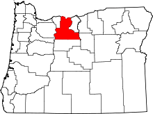 | |
| CDPs | ||
| Unincorporated communities | ||
| Indian reservation | ||
| Ghost towns | ||