Hardman, Oregon
| Hardman, Oregon | |
|---|---|
| Unincorporated community | |
|
Collapsing house in Hardman | |
 Hardman, Oregon Location within the state of Oregon | |
| Coordinates: 45°10′11″N 119°40′55″W / 45.16972°N 119.68194°WCoordinates: 45°10′11″N 119°40′55″W / 45.16972°N 119.68194°W | |
| Country | United States |
| State | Oregon |
| County | Morrow |
| Elevation | 3,563 ft (1,086 m) |
| Population (1990) | |
| • Total | 20[1] |
| Time zone | Pacific (UTC-8) |
| • Summer (DST) | Pacific (UTC-7) |
| Area code(s) | 541 |
| GNIS feature ID | 1136356 |

Hardman is a historic community in Morrow County, in the U.S. state of Oregon.[2] It is on Oregon Route 207 about 20 miles (32 km) south of Heppner and 32 miles (51 km) north of Spray.[3] Hardman is at an elevation of about 3,600 feet (1,100 m) in an agricultural area slightly west of the Blue Mountains of northeastern Oregon.[3] Rock Creek, a tributary of the Columbia River, flows northwest by Hardman and to its south to meet the river at Lake Umatilla.[4] A former social and commercial center for surrounding farm communities, Hardman has become a ghost town.[3][5] The main surviving commercial building, the Hardman IOOF Lodge Hall, was added to the National Register of Historic Places (NRHP) in 2012.[3]
History
| Historical population | |||
|---|---|---|---|
| Census | Pop. | %± | |
| 1900 | 121 | — | |
| 1910 | 191 | 57.9% | |
| 1920 | 193 | 1.0% | |
| 1930 | 120 | −37.8% | |
| 1940 | 83 | −30.8% | |
| 1950 | 58 | −30.1% | |
| 1960 | 30 | −48.3% | |
| 1970 | 19 | −36.7% | |
| 1990 | 20 | — | |
| [1] | |||
The first settlers in the area were John F. Royse and his brother.[6] Royse started a school in 1879 at a place called Dairyville, which locals referred to as "Rawdog".[6] At the same time, David N. Hardman, who arrived in the county in 1878, started a settlement a mile to the southeast.[6] A post office named Hardman was established there in 1881 with Hardman as postmaster.[6] A mile to the northwest of Dairyville was the community of Adamsville, known to the locals as "Yallerdog".[6] In 1882, the Hardman post office was moved to Dairyville but retained the Hardman name.[6] Adamsville post office was established in 1884 and closed in 1885, and thereafter, all activity centered on what is now Hardman, where the post office ran intermittently until 1968.[6] Locals called the place "Dogtown" after its two predecessors.[6] Why the locals named these communities after dogs is unknown.[3]
According to the NRHP nomination form for the IOOF hall, a history of Umatilla and Morrow counties that was published in 1902 said that Hardman at that time had three general stores, two hotels, two feed stables, two blacksmiths, a saloon, a barber shop, a church, schools, a post office, a newspaper, and a telephone office. Other infrastructure included two meeting halls, a skating rink, and a racetrack.[3]
See also
References
- 1 2 Moffatt, Riley Moore (1996). Population History of Western U.S. Cities and Towns, 1850–1990. Lanham, Maryland: Scarecrow Press. p. 210. ISBN 978-0-8108-3033-2.
- ↑ "Hardman (historical)". Geographic Names Information System. United States Geological Survey. November 28, 1980. Retrieved July 26, 2013.
- 1 2 3 4 5 6 Wright, Rhonda; Keeney, Rosalind (November 11, 2011). "National Register of Historic Places Registration Form: Hardman IOOF Lodge" (PDF). Oregon Historic Sites Database. Retrieved July 26, 2013. "NR Nomination" link at the database site retrieves the PDF file.
- ↑ The Road Atlas (2008 ed.). Chicago: RandMcNally. pp. 84–85. ISBN 0-528-93961-0.
- ↑ Friedman, Ralph (1982) [1972]. Oregon for the Curious (3rd revised ed.). Caldwell, Idaho: The Caxton Printers. p. 191. ISBN 0-87004-222-X.
- 1 2 3 4 5 6 7 8 McArthur, Lewis A.; Lewis L. McArthur (2003) [1928]. Oregon Geographic Names (7th ed.). Portland, Oregon: Oregon Historical Society Press. pp. 8, 444. ISBN 0-87595-277-1.
External links
- Historic images of Hardman from Salem Public Library
- A 1940 Journey Across Oregon an Oregon State Archives Exhibit
- Photos of Hardman on Flickr
- Hardman photo gallery at ghosttowngallery.com
Municipalities and communities of Morrow County, Oregon, United States | ||
|---|---|---|
| Cities | 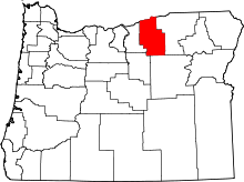 | |
| Unincorporated communities | ||
| Ghost town | ||