Oldambt (municipality)
| Oldambt | |||
|---|---|---|---|
| Municipality | |||
| |||
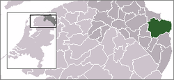 Location of Oldambt in Groningen in the Netherlands | |||
| Coordinates: 53°9′N 7°2′E / 53.150°N 7.033°ECoordinates: 53°9′N 7°2′E / 53.150°N 7.033°E | |||
| Country | Netherlands | ||
| Province | Groningen | ||
| Established | 1 January 2010[1] | ||
| Government[2] | |||
| • Body | Municipal council | ||
| • Mayor | Pieter Smit (D66) | ||
| Area[3] | |||
| • Total | 295.96 km2 (114.27 sq mi) | ||
| • Land | 227.80 km2 (87.95 sq mi) | ||
| • Water | 68.16 km2 (26.32 sq mi) | ||
| Elevation[4] | 2 m (7 ft) | ||
| Population (May 2014)[5] | |||
| • Total | 38,495 | ||
| • Density | 169/km2 (440/sq mi) | ||
| Time zone | CET (UTC+1) | ||
| • Summer (DST) | CEST (UTC+2) | ||
| Postcode | Parts of 9600 and 9900 ranges | ||
| Area code | 0596–0598 | ||
| Website |
gemeente-oldambt | ||


Oldambt (Dutch pronunciation: [ˈɔldɑm(b)t]) is a municipality with a population of 38,495 in the province of Groningen in the Netherlands. It was established in 2010 by merging the municipalities of Reiderland, Scheemda, and Winschoten. It contains the city of Winschoten and the villages Bad Nieuweschans, Beerta, Blauwestad, Drieborg, Finsterwolde, Heiligerlee, Midwolda, Nieuw-Beerta, Nieuwolda, Nieuw-Scheemda, Oostwold, Scheemda, 't Waar, and Westerlee. The mayor is Pieter Smit of D66.
History
The municipality of Oldambt was established 1 January 2010, as a merger of the former municipalities of Reiderland, Scheemda and Winschoten.[6][7] The first mayor of the municipality was Martin Zijlstra,[8] and the current mayor is Pieter Smit (D66).
Geography
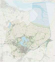
Oldambt is located at 53°9′N 7°2′E / 53.150°N 7.033°E in the northeast of the province of Groningen in the northeast of the Netherlands on the border with Germany. Near Bad Nieuweschans is the easternmost point of the Netherlands. The municipality falls within the region of Oldambt and the western part falls within the region of Rheiderland.
The municipality is bordered by the Dutch municipalities of Delfzijl (in the north), Slochteren (northwest), Menterwolde (west), Pekela (southwest), and Bellingwedde (south), and by the German municipalities of Bunde (east), Jemgum (northeast), and Emden (north).
The municipality contains the city of Winschoten and the villages of Bad Nieuweschans, Beerta, Blauwestad, Drieborg, Finsterwolde, Heiligerlee, Midwolda, Nieuw-Beerta, Nieuwolda, Nieuw-Scheemda, Oostwold, Scheemda, 't Waar, and Westerlee.[9]
In the north of the municipality is part of the Dollart in the Wadden Sea, which is a UNESCO World Heritage Site since 2009.[10][11] In the center is the Oldambtmeer, an artificial lake of more than 800 ha.[12]
Demographics
As of 2014, Oldambt has a population of 38,495 and a population density of 169/km2 (440/sq mi).[3][5]
Government
The seat of government is in Winschoten. The mayor is Pieter Smit of D66.
Transportation
The highway A7 (E22) connects the municipality to the city of Groningen in the west and Leer (Germany) in the east. The Harlingen–Nieuweschans railway runs through the municipality with train stations in Scheemda, Winschoten, and Bad Nieuweschans. The trains are currently operated by Arriva and the busses by Qbuzz.
The train stops Heiligerlee and Ulsda were closed in 1934 and 1938.
References
- ↑ "Gemeentelijke indeling op 1 januari 2010" [Municipal divisions on 1 January 2010]. cbs.nl (in Dutch). CBS. Retrieved 31 January 2014.
- ↑ "Samenstelling college van B&W" [Members of the board of mayor and aldermen] (in Dutch). Gemeente Oldambt. Retrieved 3 February 2014.
- 1 2 "Kerncijfers wijken en buurten" [Key figures for neighbourhoods]. CBS Statline (in Dutch). CBS. 2 July 2013. Retrieved 12 March 2014.
- ↑ "Postcodetool for 9671CD". Actueel Hoogtebestand Nederland (in Dutch). Het Waterschapshuis. Retrieved 3 February 2014.
- 1 2 "Bevolkingsontwikkeling; regio per maand" [Population growth; regions per month]. CBS Statline (in Dutch). CBS. 26 June 2014. Retrieved 24 July 2014.
- ↑ (Dutch) "Gemeente Oldambt welluidend van start", Dagblad van het Noorden, 2010. Retrieved on 6 January 2010.
- ↑ (Dutch) Eerste Kamer stemt in met vijf gemeentelijke herindelingen, Nederlands Genootschap van Burgemeesters. Retrieved on 6 January 2010.
- ↑ (Dutch) Jacob Hesseling, "Martin Zijlstra: eerste burgemeester Oldambt", Dagblad van het Noorden, 2009. Retrieved on 6 January 2010.
- ↑ (Dutch) Dorpen en wijken, Gemeente Oldambt. Retrieved on 22 December 2014.
- ↑ Wadden Sea, UNESCO. Retrieved on 22 December 2014.
- ↑ Wadden Sea - Maps, UNESCO. Retrieved on 22 December 2014.
- ↑ (Dutch) Blauwestad, Marketing Groningen. Retrieved on 22 December 2014.
External links
| Wikivoyage has a travel guide for Oldambt. |
| Wikimedia Commons has media related to Oldambt. |
- (Dutch) Official website
 |
Slochteren | Delfzijl | Emden (DE-NI), Jemgum (DE-NI) Dollart |
|
| Menterwolde | |
Westerwoldse Aa / Bunde (DE-NI) | ||
| ||||
| | ||||
| Pekela | Bellingwedde |
Municipalities of Groningen | ||
|---|---|---|
 | ||
| ||