A7 motorway (Netherlands)
| |
|---|---|
| Rijksweg 7 | |
|
Location of the A7 motorway | |
| Highway system | |
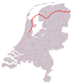
The A7 motorway is a motorway in the Netherlands connecting Zaandam, via the Afsluitdijk, Sneek and Groningen to the German border near Bad Nieuweschans. The entire road is part of the European route E22, with exception of the first kilometre, between the terminus in Zaandam and the interchange Zaandam. With a length of 236 km it is the longest motorway in the Netherlands.
Motorway interruptions
The motorway A7 is interrupted twice:
- Around Sneek, the road is demoted to a highway for several kilometres, and includes some at-grade intersections The at-grade intersections were replaced with grade-separated intersections in 2008–2010. However, it isn't a motorway.
- Also, around the city of Groningen, it is demoted over a distance of several kilometres, mainly for the at-grade intersection with motorway A28, and for the road's small alignment through the city in general.
Both of the abovementioned sections are denoted as N7 to distinguish those parts from the motorway, for which the A designation is used in the Netherlands. The A7 together with the N7 is called the Rijksweg 7.
 Westbound N7 near Groningen. |
 Interruption of the A7 in Groningen. |
Speed limit experiment
From March 2011, on a section of the A7 motorway, motorists were allowed to drive at 130 km/h (80 mph), opposed to the then national speed limit of 120 km/h (75 mph). This was a government test to investigate if driving at these higher speeds have an effect on the environment and safety. The test resulted positively, and the national speed limit was raised to 130 km/h (80 mph) in October 2012.
Afsluitdijk
The A7 runs across a historic part of Dutch engineering, the Afsluitdijk. This dam was originally created to protect the country's long interior coastline from floods by creating a large freshwater lake. The road over the Afsluitdijk was previously a 2-lane N road, but is now a proper motorway; the upgrade to motorway was achieved by utilising the dike's unused railway reservation for the second carriageway. Its midpoint is near the village of Breezanddijk. The former State Secretary for Infrastructure and the Environment, Joop Atsma, issued a statement detailing the factors influencing the decision to build a new naviduct on the Afsluitdijk section of the A7 at Kornwerderzand. A naviduct and new locks was costed at €200–450 million, depending on the size of locks and size of highway. A naviduct would give waiting time annualised benefits €13 million to road traffic, based on the existing bridge opening 7,000 times a year. Cost–benefit analysis of all potential solutions were considered, and a naviduct could be built to replace the locks when they reach the end of their useful life in 2050.[1]
Exit list
| Country | Province | Municipality | km | mi | Exit | Destinations | Notes |
|---|---|---|---|---|---|---|---|
| Netherlands | North Holland | Zaanstad | 4 | 2.5 | — | ||
| 5 | 3.1 | — | West end of E 22 overlap | ||||
| 7 | 4.3 | 2 | |||||
| Wormerland | 11 | 6.8 | 3 | Oosterdwarsweg | |||
| Purmerend | 14 | 8.7 | 4 | Laan der Continenten | |||
| 15 | 9.3 | 5 | |||||
| 17 | 11 | 6 | |||||
| Koggenland | 29 | 18 | 7 | ||||
| Hoorn | 32 | 20 | 8 | Provincialeweg | |||
| 34 | 21 | 9 | |||||
| Medemblik | 36 | 22 | 1 | ||||
| 39 | 24 | 10a | Tuinstraat / Broerdijk | ||||
| 43 | 27 | 11 | |||||
| Wieringermeer | 50 | 31 | 12 | ||||
| 55 | 34 | 13 | |||||
| Wieringen | 64 | 40 | 14 | ||||
| IJsselmeer / Wadden Sea | Afsluitdijk | ||||||
| Friesland | Súdwest Fryslân | 101 | 63 | — | |||
| 101 | 63 | 15 | |||||
| 105 | 65 | 16 | Weersterweg | ||||
| 110 | 68 | 17 | |||||
| 112 | 70 | 18 | Kloosterlaan | ||||
| 115 | 71 | 19 | Tsjaerddyk / Hottingawei | ||||
| 118 | 73 | 20 | State As | West end of N7 road designation | |||
| 119 | 74 | 21 | |||||
| 119 | 74 | 21a | Akkenwinde / Selfhelpweg | Westbound exit and eastbound entrance only | |||
| 120 | 75 | 22 | East end of N7 road designation | ||||
| Skarsterlân | 133 | 83 | 23 | Woudfennen | |||
| 136 | 85 | — | |||||
| 140 | 87 | 25 | De Dolten / Nije Fjildwei | ||||
| Heerenveen | 142 | 88 | 26 | Wetterwille / Weinmakker / Nije Fjildwei | Westbound exit and eastbound entrance only | ||
| 144 | 89 | — | |||||
| 147 | 91 | 26a | Zestienroeden / Pastoriesingel | ||||
| Opsterland | 152 | 94 | 27 | ||||
| 158 | 98 | 28 | Beetserweg | ||||
| Smallingerland | 161 | 100 | 29 | Zuiderhogeweg | |||
| 165 | 103 | 30 | |||||
| 165 | 103 | 30a | |||||
| Opsterland | 170 | 110 | 31 | ||||
| Groningen | Marum | 176 | 109 | 32 | |||
| 180 | 110 | 33 | |||||
| Leek | 184 | 114 | 34 | ||||
| Groningen | 191 | 119 | 34a | Westpoortboulevard / Matsloot | |||
| 193 | 120 | 35 | |||||
| 196 | 122 | 36 | West end of N7 road designation | ||||
| 196 | 122 | 36a | Westbound entrance only | ||||
| 197 | 122 | — | |||||
| 198 | 123 | 37 | Hereweg | ||||
| 198 | 123 | 37a | Meeuwerderbaan / Europaweg / Winschoterdiep | Westbound entrance and eastbound exit only | |||
| 199 | 124 | 38 | Europaweg / Bergenweg / Lübeckweg / Osloweg / Euvelgunnebrug / Gotenburgweg / Kieler Bocht / Skagerrak | ||||
| 204 | 127 | — | |||||
| 205 | 127 | 39 | Europaweg | East end of N7 road designation | |||
| Hoogezand-Sappemeer | 213 | 132 | 40 | ||||
| 215 | 134 | 41 | |||||
| 218 | 135 | 42 | Noordbroeksterstraat / Rijksweg oost | ||||
| Menterwolde | 222 | 138 | 43 | Kerkstraat / Europaweg / Burgemeester Omtaweg | |||
| 224 | 139 | 44 | |||||
| Oldambt | 230 | 140 | 45 | ||||
| 232 | 144 | 46 | |||||
| 240 | 150 | 47 | |||||
| 246 | 153 | 48 | Ulsda / Ulsderweg / Heeresloot | ||||
| 251 | 156 | 49 | Hamdijk | ||||
| Groningen / Lower Saxony province line | Reiderland / Bunde municipality line | — | Border with Germany; this road continues as the German A280; east end of E 22 overlap | ||||
1.000 mi = 1.609 km; 1.000 km = 0.621 mi
| |||||||
References
- ↑ Atsma, Joop (3 July 2012). "Toezegging naviduct Afsluitdijk" (PDF) (in Dutch). Ministerie van Infrastructuur en Milieu. Retrieved 2 August 2013.
External links
![]() Media related to Rijksweg 7 at Wikimedia Commons
Media related to Rijksweg 7 at Wikimedia Commons