Ochlockonee River State Park
| Ochlockonee River State Park | |
|---|---|
|
IUCN category V (protected landscape/seascape) | |
 | |
 | |
| Location | Wakulla County, Florida, United States |
| Nearest city | Sopchoppy |
| Coordinates | 29°59′56.8″N 84°29′6″W / 29.999111°N 84.48500°WCoordinates: 29°59′56.8″N 84°29′6″W / 29.999111°N 84.48500°W |
| Area | 392 acres (1.59 km2) |
| Governing body | Florida Department of Environmental Protection |
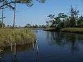
Ochlockonee River State Park is a Florida State Park. It is located on the Gulf coast, on U.S. 319 about four miles (6 km) south of the town of Sopchoppy.
Ecology
The 392 acre (1.6 km2) park includes pine flatwoods and oak thickets, and is notable for containing a significant habitat for the endangered red-cockaded woodpecker.
Recreational Activities
The park has such amenities as bicycling, birding, boating, canoeing, fishing, hiking, kayaking, picnicking areas, swimming, wildlife viewing and full camping facilities.
Gallery


External links
- at Florida State Parks
- Ochlockonee River State Park at State Parks of the United States
- Ochlockonee River State Park at Absolutely Florida
This article is issued from Wikipedia - version of the 11/19/2016. The text is available under the Creative Commons Attribution/Share Alike but additional terms may apply for the media files.