Cross Florida Barge Canal


The Cross Florida Barge Canal, now officially the Marjorie Harris Carr Cross Florida Greenway is a protected green belt corridor, one mile (1.6 km) wide in most places.[1][2] It is named for the leader of opposition to the Cross Florida Barge Canal, a canal project to connect the Gulf of Mexico and the Atlantic Ocean across Florida for barge traffic. Two sections were built but the project was cancelled, mainly for environmental reasons.
The Greenway includes the Santos Trail System.
History
The idea of such a canal was first proposed by Philip II of Spain in 1567. It was repeatedly considered over the years but found to be economically unviable. Secretary of War John C. Calhoun once again proposed a canal in 1818 in order to solve the losses due to shipwrecks and piracy. The Florida Railroad, finished on March 1, 1861, served a similar purpose, connecting the Atlantic Ocean at Fernandina to the Gulf of Mexico at Cedar Key.
In the 1930s, regional politicians lobbied the federal government to fund canal construction as an economic recovery program, including the creation of the Canal Authority of the State of Florida in May 1933.[3] President Franklin D. Roosevelt allocated $5 million in emergency funds in 1935.[4] Local opponents of the canal protested that the canal would deplete Florida's aquifers, and work was stopped a year later.
Work was reauthorized in 1942 as a national defense project, with dams and locks to protect the underground water supply. Support for the project from Washington was sporadic, and funds were never allocated to USACE to actually start construction.
Planning was once again given the go-ahead in 1963 with support from President John F. Kennedy, who allocated one million dollars to the project. The next year, President Lyndon Johnson set off the explosives that started construction. It was hoped that the canal, along with the St. Johns-Indian River Barge Canal, would provide a quicker and safer route across Florida by 1971.
Opponents subsequently campaigned against the canal on environmental grounds, and the project halted again on January 19, 1971 by President Richard Nixon's signing of an executive order.[3] Approximately $74 million had been spent on the project up until the 1971 cessation of activities.[3] It was officially cancelled in 1991. In 1998, the right-of-way was turned over to the state and became the Marjorie Harris Carr Cross Florida Greenway, named in honor of Marjorie Harris Carr, who had led opposition to the canal. Carr had died the prior year at age 82.
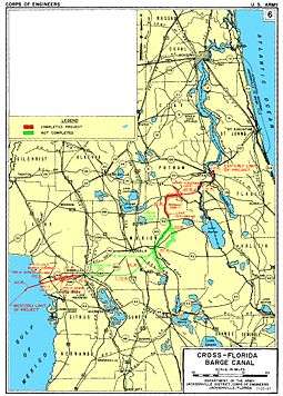
Canal route
The planned route of the canal followed the St. Johns River from the Atlantic coast to Palatka, the valley of the Ocklawaha River to the coastal divide, and the Withlacoochee River to the Gulf of Mexico. About 28% of the 107-mile (172 km) project was built—the cross-country section 29°32′15″N 81°44′48″W / 29.53750°N 81.74667°W from the St. Johns River to the Ocklawaha River, part of the route along the Ocklawaha, and a small section 29°00′46″N 82°39′54″W / 29.01278°N 82.66500°W at the Gulf of Mexico end up to the dammed Lake Rousseau.
Economic impact
The canal was intended to connect the Atlantic Intracoastal Waterway with the Gulf Intracoastal Waterway at St. Marks, Florida, with a short run across the open water of Apalachicola Bay, which is the calmest corner of the Gulf of Mexico. The military and economic impact was expected to be tremendous in that it "...promote the national defense and to promptly facilitate and protect the transport of materials and supplies..."[5] the canal would save travel time and distance for shipping companies through avoiding the longer route through the Florida Straits and link Florida's inland waterways to both coasts.
Bridges and other infrastructure
All the bridges over the St. Johns River north of the canal are high enough for ships, or have movable sections. High bridges were built over the canal, as well as several over the Ocklawaha River where it was not widened to the canal. The following are the major roads, railroads, and locks and dams cross the path of the canal:
- Buckman Lock (formerly St. Johns Lock)
- SR 19 (high bridge)
- George Kirkpatrick Dam (formerly Rodman Dam), south of the canal on the Ocklawaha River, forming Rodman Reservoir along the canal
- Eureka Dam (unfinished)
- CR 316 (high bridge)
- SR 40, Bert Dosh Memorial Bridge (high bridge)
- CR 314 (no bridge)
- SR 35 (no bridge)
- SR 464 (no bridge)
- Florida Northern Railroad (no bridge)
- CSX S-Line (no bridge)
- US 27-301-441 (SR 25/SR 500) (no bridge, but several unused supports in the median)
- CR 475 (no bridge)
- I-75 (SR 93) (no bridge; recently built land bridge over I-75 for trail users)
- SW 49th Avenue (no bridge; recently built underpass for trail users)
- CR 484 (no bridge)
- SR 200 (no bridge)
- CSX line (low bridge over the existing Withlacoochee River)
- US 41 (SR 45), Brittan Alexander Bridge (low bridge over the existing Withlacoochee River)
- Inglis Lock (Inglis Dam is south of the canal on the Withlacoochee River, forming Lake Rousseau along the canal)
- US 19-98 (SR 55), Trooper Ronald Gordon Smith Memorial Bridge (Twin bridges that replaced a much higher bridge in 2010)
Between Lake Rousseau and the Ocklawaha River, discontinuous, unwatered excavations mark the canal's planned path, along with different vegetation patterns on the land acquired for the project (as seen from the air).
Project timeline
- May 1933 - Canal Authority of the State of Florida was created to construct and maintain a deep-water ship canal across Florida.
- 1935-1936 – Construction of a ship canal began under the Emergency Relief Appropriations Act of 1935, but work was suspended when Federal funds were depleted.
- July 1942 – Congress authorized construction of the Cross Florida Barge Canal.
- February 1964 – The U. S. Army Corps of Engineers began construction of the Cross Florida Barge Canal.
- 1969 – The Environmental Defense Fund and others filed suit in the U. S. District Court for the District of Columbia seeking temporary and permanent injunction against the construction of the canal.
- January 15, 1971 – The District Court granted a preliminary injunction halting any further construction activities pending the outcome of the litigation.
- January 19, 1971 – President Richard Nixon signed an executive order suspending further work on the Barge Canal. When halted, the project was one-third complete and approximately $74 million had been spent on land acquisition and construction.
- 1979 – Bills filed in Congress to deauthorize the Canal failed to pass.
- May 22, 1990 - A revised federal bill was filed in the U. S. Senate by Senators Bob Graham and Connie Mack providing, among other things, for a minimum 300-yard wide greenway corridor to be maintained along the former Barge Canal route. This bill was agreed to by the entire Florida Congressional delegation.
- May 31, 1990 - The Florida Legislature enacted a deauthorization bill conforming to the consensus bill filed in the U. S. Senate. Most of the provisions were not effective until Congress deauthorized the project.
- October 27, 1990 – Senate Bill 2740 was passed by Congress and sent to the President for signature. The bill deauthorized the Cross Florida Barge Canal project upon acceptance by the Governor and Cabinet of the State of Florida.
- November 28, 1990 – President George Bush signed SB 2740 into law deauthorizing the Cross Florida Barge Canal project and changing the purpose of the lands to recreation and conservation.
- January 22, 1991 – The Governor and Cabinet of the State of Florida signed a resolution agreeing to the terms of the Federal deauthorization bill thereby officially deauthorizing the Cross Florida Barge Canal project. This action ultimately led to the creation of the Cross Florida Greenway State Recreation and Conservation Area.
- 1998 - The Cross Florida Greenway was officially renamed the Marjorie Harris Carr Cross Florida Greenway in honor of the individual who led the fight to stop the Cross Florida Barge Canal project.
References
- ↑
- ↑ From Exploitation to Conservation, A History of The Marjorie Harris Carr Cross Florida Greenway, Page 14, http://pbadupws.nrc.gov/docs/ML1204/ML12044A397.pdf
- 1 2 3 http://www.floridastateparks.org/crossflorida/doc/additionalinformation/cfg-history.pdf
- ↑ Hiort-Lorenzen. "Channel through Florida" (in Danish) with map. Bygningsteknik, page I-9 to I-10. Nr. 3, 11 January 1936.
- ↑ http://legisworks.org/sal/56/stats/STATUTE-56-Pg703.pdf
External links
| Wikimedia Commons has media related to Cross Florida Barge Canal. |
- Florida DEP - Marjorie Harris Carr Cross Florida Greenway
- US Army Corps of Engineers - Cross-Florida Barge Canal - 1996 Condition of Improvement - Page no longer available
- US Army Corps of Engineers - Cross-Florida Barge Canal {Wayback Machine - Archived Page}
- US Army Corps of Engineers - Henry H. Buckman Lock {Wayback Machine - Archived Page}
- US Army Corps of Engineers - Atlantic-Gulf Ship Canal (Wayback Machine - Archived Page)
Coordinates: 29°32′15″N 81°44′48″W / 29.5374695°N 81.7467501°W