Nurney, County Kildare
| Nurney An Urnaí | |
|---|---|
| Town | |
 Nurney Location in Ireland | |
| Coordinates: 53°05′42″N 6°56′52″W / 53.09494°N 6.94784°WCoordinates: 53°05′42″N 6°56′52″W / 53.09494°N 6.94784°W | |
| Country | Ireland |
| Province | Leinster |
| County | County Kildare |
| Elevation | 71 m (233 ft) |
| Population (2011) | |
| • Urban | 389 |
| Time zone | WET (UTC+0) |
| • Summer (DST) | IST (WEST) (UTC-1) |
| Irish Grid Reference | N704056 |
Nurney (Irish: An Urnaí meaning "Oratory/prayer house/chapel") is a village in County Kildare, Ireland on the Tully Stream. It lies on the R415 regional road 8 km south of Kildare and is signposted from the M7 motorway at junction 13.
The village has a church, a pub, a school, a shop, and two graveyards. A petrol station and chip shop opened in the village in recent times.

Demographics
In 2006, its population was recorded at 354 an increase of 48% from 2002 owing to an influx of settlers from Dublin, which lies some 60 km away.
Transport
Bus
South Kildare Community Transport's Newbridge-Kildare-Athy route serves Nurney on Mondays to Fridays with two services each way a day. The bus also serves Kildare railway station, the nearest station to Nurney, enabling journeys to/from many parts of Ireland.[1]
Arts
- Skerries Irish Figure Dancing Class has been teaching Irish Figure dancing for over 40 years and classes are held weekly in the local GAA hall.
Sport
- Nurney GAA is the local Gaelic Athletic Association club.
See also
References
- http://www.cso.ie/census/documents/census2006_Table_7_and_12.pdf
- http://www.irelands-directory.com/Carlow/Nurney/Entertainment/Pubs.html
Places in County Kildare | ||
|---|---|---|
| Towns | 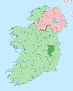 | |
| Villages and Townlands |
| |
| Landforms | ||
| Topics |
| |