Newbridge, County Kildare
| Droichead Nua · Newbridge | |
|---|---|
| Town | |
|
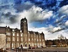
Newbridge College at sunset | |
 Location in Ireland | |
| Coordinates: 53°10′50″N 6°47′45″W / 53.18042°N 6.79590°WCoordinates: 53°10′50″N 6°47′45″W / 53.18042°N 6.79590°W | |
| Country | Ireland |
| Province | Leinster |
| County | County Kildare |
| Elevation | 90 m (300 ft) |
| Population (2011) | |
| • Rank | 15th |
| • Urban | 17,127 |
| Irish Grid Reference | N801152 |
| Website |
www |

Newbridge, officially known by its Irish name Droichead Nua [ˈd̪ˠɾˠɛçəd̪ˠ n̪ˠuə], is a town in County Kildare, Ireland. Its population of 21,561 (2011 census[1]) makes it the largest town in Kildare and the fifteenth-largest in Ireland.
Name
The Irish language name of the town is the official name, "An Droichead Nua", meaning simply "The New Bridge" and was introduced in the 1930s. Noble and Keenan's map of Kildare 1752, drawn before the town was started, marks 'The New Bridge'.
History
Early local settlement
Settlement in the area dates from the 13th century (with the foundation of Great Connell Abbey in 1202) and the current town is made up of six ancient parishes and portions of others. The parishes are Ballymany, Great Connell, Killashee, Morristown Billar, Old Connell, and Carnalway.
Great Connell Priory was an important Priory, founded in 1202 by the Augustinian Canons. This and other sites are a reminder that Newbridge was an early Christian settlement.
Beginning of the modern town
| Historical population | ||
|---|---|---|
| Year | Pop. | ±% |
| 1831 | 577 | — |
| 1841 | 792 | +37.3% |
| 1851 | 934 | +17.9% |
| 1861 | 2,875 | +207.8% |
| 1871 | 3,286 | +14.3% |
| 1881 | 3,372 | +2.6% |
| 1891 | 3,207 | −4.9% |
| 1901 | 2,903 | −9.5% |
| 1911 | 3,400 | +17.1% |
| 1926 | 2,249 | −33.9% |
| 1936 | 2,375 | +5.6% |
| 1946 | 3,151 | +32.7% |
| 1951 | 3,007 | −4.6% |
| 1956 | 4,157 | +38.2% |
| 1961 | 4,419 | +6.3% |
| 1966 | 5,161 | +16.8% |
| 1971 | 6,444 | +24.9% |
| 1979 | 5,758 | −10.6% |
| 1981 | 10,716 | +86.1% |
| 1986 | 11,503 | +7.3% |
| 1991 | 12,971 | +12.8% |
| 1996 | 13,363 | +3.0% |
| 2002 | 19,542 | +46.2% |
| 2006 | 18,520 | −5.2% |
| 2011 | 21,561 | +16.4% |
| [2][3][4][5][6] | ||
The earliest known mention of Newbridge was by traveller and bookseller John Dunton in 1698 , though he does not refer to any settlement other than at Ballymany. A mass house (Roman Catholic Chapel) was built beside the bridge about 1730 and an Inn, called New Bridge Inn, was in existence in 1750. The first bridge was destroyed by floods in 1789 and William Chapman, engineer on the Grand Canal extension to Naas, was employed to rebuild it the following year. He moved the site from the 'Watering Gates' to its present location and redirected the high road from Buckley's Cross (Roundabout at Pfizer) to the new bridge, and continuing as what is today Main Street and Edward Street to the turnpike at Gandogue Lane (behind Credit Union). The old high road continued in use to serve the village and mass house, which was taken down in 1852 upon the opening of the new church (St Conleth's).
.jpg)
The origin of the modern town lies in the establishment of Cavalry Barracks (1815–1819) on land purchased from 3 local landlords: Eyre Powell of Great Connell, Ponsonby Moore of Moorefield and William Hannon of Kilbelin. This barracks originally extended from the River Liffey to Cutlery Road, and from Main Street to Military Road, however little of the barracks remains today except the old walls and gateways which can be found on the Athgarvan Road, and to a lesser degree on Cutlery Road. The "Watering Gates" located at the entrance to the Town Park was also constructed as part of the original Barrack building (and as the name suggests this "gate" was used to facilitate access to the river for the horses from the barracks). At the same Eyre Powell gave land north of the new high road for building houses and shops to serve the new Barracks. Main Street took shape at the same time as the Barracks were being built. From 1819 various Cavalry Regiments were stationed at Newbridge and brought much business to the town.
Newbridge expanded rapidly after the Curragh Camp was established in 1855. Eyre Street (named after the local landlord Eyre Powell) and Edward Street (named after Prince Edward, later King Edward VII, who was stationed on the Curragh at the time) were built in the years 1855 – 1870. The new railway opened in 1846 and churches were built at Rosberry Common (1819 – St. Eustace', Dominican), at Moorefield (1828 – St Patrick's, Church of Ireland) and at Chapel Lane (1852 – St Conleth's, Roman Catholic) to cater for the increasing population. A National School was opened on the Railway Road in 1842 (now the Parish Office) and a boarding school at the Dominican Friary in 1852. The town continued to prosper until the withdrawal of the Cavalry in May 1922 on the establishment of the Free State. It went into a period of decline thereafter, but since the 1960s has seen considerable growth and has become a busy shopping and commuter town.
Location
The town is located on the banks of the River Liffey, which provides a range of natural amenities. Upriver are towns such as Athgarvan, Kilcullen and Blessington, while downriver are the towns of Caragh, Clane and Celbridge.
Newbridge / An Droichead Nua is bounded by the Curragh Plains to the west, Pollardstown Fen and the Bog of Allen and Moulds Bog to the north west. Around the Curragh, and to the east are many important stud farms. To the south the motorway now forms a boundary to the town.
Today Newbridge is a thriving town with a population approaching 22,000, a major centre for industry and commerce, within the South Kildare region.
Industry
The area has a strong industrial background with industry such as rope making Irish Ropes PLC (established 1933, now closed) and carpet manufacturing ( Curragh Tintawn Carpets Ltd. established 1937, Closed 2012). Cutlery and silverware is crafted at the famous Newbridge Silverware plant. Pharmaceutical companies such as Pfizer and Oral-B have also based themselves in the town.
The Irish peat development authority Bord na Móna has its headquarters in the centre of Newbridge.
The Kildare/Leixlip Branch of General Workers Union SIPTU has its headquarters at Georges Street, Newbridge.
The Department of Defence is located on Station road
Many people living in Newbridge commute to work in major centres like in nearby Dublin city.
Chocolate by Irish chocolatier Lily O'Briens is based in IDA Business Park, Green Road, Newbridge.
Pfizer Ireland is located at Little Connell, Newbridge. Pfizer is one of the world's premier research-based biopharmaceutical companies. It discovers, develops, manufactures and markets prescription human and veterinary medicines, and consumer healthcare products. It is one of the largest pharmaceutical companies in the world.
Transport
Rail
The town has excellent rail links both to most areas of Ireland. The town is situated on the main Dublin-Cork railway line and connects the town to Dublin and the main provincial cities and regions in Ireland such as Cork, Limerick, Galway, Waterford and Westport. A regular commuter train service operates between Newbridge and Dublin. Newbridge railway station opened on 4 August 1846 and was closed for goods traffic on 6 September 1976.[7]
Road
The M7 motorway bypasses the town; the R445 connects the town to the bypass (Junctions 10 and 12 on the M7) along the route previously forming part of the N7. The M9 to Kilcullen, Carlow, Kilkenny and Waterford leaves the M7 west of Naas at Junction 11.
Bus
A private bus service known as Dublin Coach also operates a service through the town linking the town to the Luas and Dublin Airport.
Shopping
There is a wide and diverse selection of shops, coffee shops, restaurants, hotels and bars in the town, including everything from the large international brands to long established local traders.
Major retailers such as Debenhams, Marks and Spencer and Eason along with others such as Zara, Bershka, and River Island are all tenants of the shopping centre. The Whitewater development has recently caused some local unrest due to the developers reneging on their promise to construct a cinema in the centre. Proposals had been made to construct a cinema elsewhere in the town by the developers but this had not lessened public outcry. A 6 screen all-digital cinema, operated by UCI, is now open within the original reserved space, it opened in December 2009.[8]
Shops such as Penneys and TK Maxx have also opened in Newbidge within five minutes walk from the Whitewater shopping centre. Both shops provide outfits to people of all ages, from newborn to elderly.
Churches


There are many churches in Newbridge and the town is home to a number of denominations.
In the Roman Catholic divisions, Newbridge is situated in St. Conleth's Parish (http://www.newbridgeparish.ie/) in the Diocese of Kildare and Leighlin, and the parish has a total of three churches in the town: St Conleth's Parish Church (1852), Cill Mhuire (1983) and the Dominican St. Eustace's Church (1966). A Church of Ireland church (1828) is located in the Moorefield area of town, and is part of St. Patrick's Anglican Parish.
Newbridge Sports Centre hosts the African faith group "The Kingdom of Heavenly Water, Fire and Mountains" and a Jehovah's Witness Kingdom Hall is located just outside the town, near Milltown. Open Arms Community Church is located within Newbridge Industrial Estate. Newbridge Bible Fellowship Church is located in the Roseberry section of the town.
Education
Primary
Primary schools in the town include Scoil Mhuire, Gaelscoil Chill Dara (an Irish-medium school), The Patrician Primary School, St Conleth's Infant Primary School, St Conleth's & St Mary's Primary School, St Patrick's National School, Newbridge Educate Together National School, and Scoil Bride in Athgarvan.
The large growth in the town's population has led to a shortage of places at primary school level.
Secondary
Secondary schools in the area are the Patrician Secondary School, the Holy Family Secondary Schoolhttp:[http:////www.holyfamily.ie/ , St Conleth's Vocational School, Newbridge College, a fee-paying co-educational secondary school, run by the Dominican Order, Leinster Senior College, a small private fee-paying school and, near the town, Gaelcholáiste Chill Dara, Kildare's only Irish-speaking second-level school: established in 2003, it provides a full programme of study through the medium of the Irish language.
St Conleth's is also home to a branch of the National College of Ireland, which offers a small number of "level-five" courses to Leaving Certificate students.
Sundai Ireland International School, a Japanese international school, was previously in Newbridge.[9]
Adult education
- The Kildare VTOS adult education centre is located in the town centre. VTOS offers level five qualifications to mature students.
People
- Christy Moore – singer and musician
- Luka Bloom (born Barry Moore), musician
- Dónal Lunny, musician
- Sinéad O'Carroll, singer
- Kathleen Lonsdale, scientist
- Clare Daly, political
- Pat Eddery, jockey
- Super Extra Bonus Party (Band).
- Jarlath Regan Comedian
- Paddy Dowling (local hero)
- Keith Walsh TV/Radio presenter.
- Shannon Edge Boxer [10]
Sport and recreation
Clubs and societies
- Newbridge is home to Kildare Gaelic Athletic Association's county grounds and sports two strong local club teams, Sarsfield's GAA and Moorefield GAA, .
- Newbridge Rugby Club is situated in nearby Rosetown.
- The town is also home to Kildare County FC, Kildare's former representative in the League of Ireland.
- Ryston pitch and putt club
- The Kildare History & Family Research Centre is based at the library in Newbridge and houses an extensive local history collection as well as a genealogical research service.
- Newbridge Tidy Towns Association's main aim is to improve the living environment in the town, the Association also enter the town into the National Tidy Towns Competition.
- Newbridge RFC is the town's only Rugby Club. Founded in 1996, with the amalgamation of the Curragh RFC and Kilcullen RFC, Newbridge RFC compete in the J1 Division 1 Leinster League.
- Newbridge Town F.C is there for any soccer enthusiasts who are looking for a soccer club with a long history and great facilities. Also the Sunday team made history this year by gaining promotion and becoming the only second ever to compete in the senior league in the KDFL!
- Newbridge cycling club (NCC) is the towns only cycling club, founded decades ago it is now a strong club of about 25 members and even hosts FBD ras stage winner Liam Baxter.
- Newbridge Colts Football Club play in Chapel Lane behind the Parish Church. The club currently play in the KDFL Premier Division.
- Newbridge Musical Society has been in operation since the 1980s, and brings yearly musical productions of the highest calibre to the stage of Newbridge College. The society has been nominated for, and indeed has won many A.I.M.S. (Association of Irish Musical Societies) awards over the past decade. Its previous acclaimed productions include Oklahoma!, Singin' in the Rain, Sweet Charity, Oliver!, My Fair Lady, 42nd Street and most recently Little Shop of Horrors amongst many others. They are currently preparing for their 2011 production of Jesus Christ Superstar which will be directed by Newbridge native Sharon McNamara and the musical direction will be by another native of Newbridge, Owen C Lynch.
- Newbridge is home to the Newbridge Racing Pigeon Club which has its club house on the grounds on the Ryston Social Club and is affiliated to the Ryston Club. It has over twenty flying members which fly in the South Road Central Federation as part of the greater Irish Homing Union South Road. Newbridge RPC does very well in their federation. Members range from the young to the experienced and all people are welcome to apply for membership.
Amenities
- Newbridge has a public library and an excellent arts centre.
- There are also a sports centre (with both indoor and outdoor facilities), three gyms, two swimming pools, a well equipped children's playground, and numerous sports and leisure clubs.
- The Liffey Linear Park provides a first class outdoor amenity for walking and relaxation alongside the River Liffey. This park, comprising seven acres, currently stretches from the bridge to the Athgarvan Road (Gables Leisure centre).
- There are a large number of first class golf courses in the area, with water sports, fishing and the Curragh Racecourse all within easy access.
- Nearby (and within walking distance of the town) are the Curragh Plains, Moulds Bog (Roseberry), and Pollardstown Fen, all areas of great natural beauty.
- Newbridge hosts Kildare's only greyhound racing track.
- In recent years the Riverbank Arts Centre has provided a new venue for a wide array of live performances, adding a new dimension to the town's long established dramatic and musical traditions.
- Newbridge is a popular venue by night, as well, with plenty of bars and nightclubs serving the area.
- For young people interested in music, local bar Rose Earley's hosts an open mic night every week.
- For snooker, pool and table tennis enthusiasts there is a new venue called Sharkx open.
- There is a Fully Digital 3D 6 Screen Cinema in the Whitewater Shopping Centre.
- The Gables Guest House & Leisure Centre is located on Ryston, Kilcullen Road, Newbridge. It offers facilities such as indoor heated 20m swimming pool, modern gym, fully qualified fitness instructors and lifeguards, aerobic studio, steam room, sauna, jacuzzi and ice cold plunge room. Annual membership is available as well as pay as you go.[11]
International relations
Achievements
Since the launching of National Tidy Towns Competitions in 1958, Newbridge has been entering it and many of their entries were a success. Newbridge received: Silver Medal 2013 & 2014, Bronze Medals 2008 to 2012 inclusive, National Waterside Award 2008 (Newbridge Town Park / Liffey Linear Park), Bronze Medals 2005 to 2007 inclusive, Race against Waste 2005 (Certificate of Excellence / Highly Commended) [12]
Twin towns – sister cities
Newbridge is twinned with the town of Bad Lippspringe in Germany and the city of Ocala, Florida, United States (2008).[13]
See also
References
- ↑ Census 2006 – Table 14A – Towns 10,000 population and over
- ↑ Census for post 1821 figures.
- ↑ http://www.histpop.org
- ↑ http://www.nisranew.nisra.gov.uk/census
- ↑ Lee, JJ (1981). "On the accuracy of the Pre-famine Irish censuses". In Goldstrom, J. M.; Clarkson, L. A. Irish Population, Economy, and Society: Essays in Honour of the Late K. H. Connell. Oxford, England: Clarendon Press.
- ↑ Mokyr, Joel; O Grada, Cormac (November 1984). "New Developments in Irish Population History, 1700–1850". The Economic History Review. 37 (4): 473–488. doi:10.1111/j.1468-0289.1984.tb00344.x.
- ↑ "Newbridge station" (PDF). Railscot – Irish Railways. Retrieved 5 September 2007.
- ↑ http://www.leinsterleader.ie/news/Newbridge-to-have-cinema-by.5813860.jp
- ↑ Home page. Sundai Ireland International School. Retrieved on March 1, 2015. "Curragh Grange, Green Road, Newbridge, Co. Kildare, Ireland"
- ↑ https://www.pledgesports.org/projects/shannon-edge-boxing-sponsorship/
- ↑ http://gablesguesthouseandleisurecentre.com/index.htm
- ↑ http://www.newbridgetidytowns.com/
- ↑ "Friends Across the Ocean". City of Ocala. Retrieved 18 April 2011.
External links
| Wikimedia Commons has media related to Newbridge, County Kildare. |
- GaelScoil Chill Dara (Irish Speaking School)
- Kildare.ie Newbridge sub-site
- Kildare's genealogy services
- Newbridge Tidy Towns Association
- Newbridge Cycling Club
- Newbridge Rugby Club
Places in County Kildare | ||
|---|---|---|
| Towns | 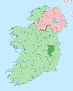 | |
| Villages and Townlands |
| |
| Landforms | ||
| Topics |
| |