Prosperous, County Kildare
| Prosperous An Chorrchoill | |
|---|---|
| Town | |
 Prosperous Location in Ireland | |
| Coordinates: 53°17′18″N 6°45′06″W / 53.28828°N 6.75172°WCoordinates: 53°17′18″N 6°45′06″W / 53.28828°N 6.75172°W | |
| Country | Ireland |
| Province | Leinster |
| County | County Kildare |
| Population (2011)[1] | |
| • Urban | 2,248 |
| Time zone | WET (UTC+0) |
| • Summer (DST) | IST (WEST) (UTC-1) |
| Irish Grid Reference | N827273 |
Prosperous (Irish: An Chorrchoill, meaning "the smooth forest") is a village in north County Kildare, Ireland. It is within the townland of Curryhills, at the junction of the R403 and R408 regional roads, about 40 km (25 mi) from Dublin. Its population of 2,248 makes it the 14th largest town in County Kildare.[2]
History
The English name of Prosperous was given when the village was founded in the late 18th century by Sir Robert Brooke. The village takes its Irish name from the townland lying to the east, Corrchoill or an Chorrchoill (meaning "the smooth forest"), anglicised variously as Corr[y]hill[s], Curr[i]hill[s] and Curryhills.[3] An alternative meaning is "The wood of the small round hill" 4 and this makes sense topographically as there is a low hill immediately to the east of the village. The village extends into the surrounding townlands of Ballinafagh, Killybegs, Curryhills and Downings (north, south, east and west, respectively).
The town of Prosperous owes its origin to the vision and ideals of Robert Brooke (East India Company officer) . The late eighteenth century was a time of attempted industrial development in Ireland and the industry upon which Prosperous was founded in 1780 was cotton manufacturing. The name chosen by Brook for his industrial town could only be the product of a confident dream. A close parallel to the development of Prosperous was Stratford-on-Slaney in Co. Wicklow, founded by Henry Stratford, Earl of Aldeborough in 1785 as a textile centre. Despite huge investment and, in the case of Prosperous, much building and an initial population of 4,000, both industrial ventures were failures. Stratford practically disappeared and Prosperous declined to such an extent as to be described by Lewis in 1837 as ‘little more than a pile of ruins' situated 'in a low marshy spot, surrounded by bogs and without water of importance nor reasonable hope of its revival' and more recently as a ‘straggling village labouring under its resounding name'.
A number of ráths have survived in the Prosperous area, indicating settlement of the place in early Christian times. Time has not been kind to these ancient fortifications although in the case of one, it has been preserved as the centre-piece of a housing development; Rath View. There is a fort, or rath, just outside Prosperous on the eastern side of The Blackstick (R409 road to Caragh).
It is possible that the townland of Downings takes its name from the word "Dún", the Irish for ‘fort', although questionable - given the higher proliferation of raths in many other parts of Ireland. Another explanation is that the local population used to converge at the nearby church on Sunday or in Irish Dé Domhnaigh [dʲeː ˈd̪ˠaun̪ˠiː] - a closer phonetic match. Some confusion arises after the late 1990s when a housing development in the village was named The Downings.
Downings graveyard and church ruins, in the townland of Downings North - north of the R403 to Allenwood, mark the place of the first Christian church in the area. Tradition states that the church occupies the site of the cell of St. Farnan whose feast is celebrated on the 15th of February. Nearby is the well of St. Farnan which is said to have been blessed by the Saint, giving it the valuable property that those who drink of its water never after have any relish for intoxicating drink. The old parish in this area was known as Downings. It was joined to the parish of Caragh in the eighteenth century.
There is another ruined church surrounded by a graveyard at Killybegs. The Knights Hospitaller of St. John of Jerusalem had a Commandery here but very little is known about it. A lease of 1538 refers to the priory and this points to its foundation before that date. The octagonal baptismal font with its carving of an angel, which is now at Prosperous church, came from Killybegs.
During penal times there was a Mass-house in the townland of Goatstown which is north of the Grand Canal. When the town of Prosperous was built, a Catholic church was erected near the cross-roads close to the present Drama Hall. This church was replaced by the present limestone church in 1869.

Thomas Harris (1895 – 18 February 1974) was an Irish Fianna Fáil politician. A native of Caragh and raised in Prosperous by his aunt Elizabeth Tierney. As a young man Thomas Harris had joined the Gaelic League while in school in Prosperous and subsequently joined the Irish Republican Brotherhood, County Kildare. Harris fought with the Maynooth contingent in 1916 Easter Rising in Dublin,and was imprisoned in Frongoch, Wales until August 1916. Harris was later Captain of the Prosperous Company in 1917 and later Vice-Commandant North Kildare Battalion of the Irish Republican Army in 1921. A farmer, he represented the constituencies of Kildare from 1927 to 1937, Carlow–Kildare from 1937 to 1948, and Kildare again from 1948 to 1957. He lost his seat at the 1957 general election and retired from politics.
The village lent its name to Christy Moore's 1972 album, Prosperous, which was recorded there.
Battle of Prosperous
The ruin of the town was accelerated by the Rising of 1798 . Prosperous was one of the first places where the United Irishmen rose. In the early morning of 24 May 1798, a large group of rebels attacked the crown forces in the town. One of the buildings holding over 50 men, including the leader, Captain Swayne, was burned. Oral tradition relates that the rebels were led by Andrew Farrell and John Esmonde and assisted by Ruth Hackett in the burning of the barracks. She is featured on the 1798 monument in the village square. The rebels held Prosperous until the crown forces recaptured it on the 19th of June. The troops were under the command of Colonel Stewart who boasted of destroying "this receptacle of rebellion". He said that the soldiers found drums with the inscription "Prosperous Strength Exists in Unity and Liberty".
The modern town
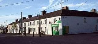
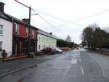
Despite the disappearance of all of the industrial buildings several of the houses of 1780 have survived along the broad Main Street with its two squares. These add great charm to the historic core of the village center. This, along with development along the main road, has effectively created a village in two sections. The main road through Prosperous is the R403 and the village is within 20 km (12 mi) of both the M4 (to the north) and M7 (to the south) motorways. Prosperous Main Street however, runs perpendicular to the R403.
The village today meets the educational, shopping, social and community needs of the people of the surrounding area. It is now developing as a residential center serving the present-day industrial development of northern Kildare and the growing city of Dublin. In 2011 it had 748 private households and its population was 2248 consisting of 1132 women and 1116 men. At that time 888 people said they spoke Irish and 167 people said they spoke another language other than English or Irish.[4]
Leisure
Dradoic Society Theatrical productions in the Drama Theatre, the Parish Centre. Check in local papers for details of the various performances. The group are always looking for new members. To become a member, pay the small membership fee to the treasurer.
Pitch and Putt Situated in the community field beside the Church. Has its own parking facilities complete with club house.
Tennis Courts Situated beside the Church accross from Prosperous primary school.[5]
Golf Society
Christy's golf society is based in Christy's Public House. It has a large and varied membership of locals and non locals who all frequent the pub. It was founded in 1995. Outings are once a month.
Soccer The local soccer club is Prosperous United A.F.C. Their website is www.prosperousunitedafc.ie
G.A.A. The local Gaelic Football team is Caragh G.F.C. and the local Hurling team is Éire Óg/Chorr Choill.
In summer months, a group of students from the Basque area of Spain come to Prosperous and stay at local homes.
Public transport
Prosperous is well served by Bus Éireann route 120 [Edenderry] as well as routes 121 [Tullamore] and 123 [Robertstown]. Buses to Dublin depart as frequently as every 15–30 minutes during peak commuter times.
See also
References
- ↑ "Prosperous Settlement Results". Central Statistics Office. 2011.
- ↑ "Prosperous Settlement Results". Central Statistics Office. 2011.
- ↑ Placenames Database of Ireland (see archival records)
- ↑ "Census" (PDF).
- ↑ "Locations – Parks Tennis". www.parkstennis.com. Retrieved 2016-11-29.
External links
| Wikimedia Commons has media related to Prosperous, County Kildare. |
Places in County Kildare | ||
|---|---|---|
| Towns | 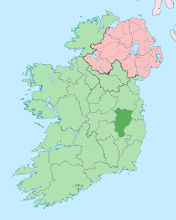 | |
| Villages and Townlands |
| |
| Landforms | ||
| Topics |
| |