Norwood Memorial Airport
| Norwood Memorial Airport | |||||||||||||||
|---|---|---|---|---|---|---|---|---|---|---|---|---|---|---|---|
 | |||||||||||||||
| IATA: OWD – ICAO: KOWD – FAA LID: OWD | |||||||||||||||
| Summary | |||||||||||||||
| Airport type | Public | ||||||||||||||
| Owner | Town of Norwood | ||||||||||||||
| Location | Norwood, Massachusetts | ||||||||||||||
| Elevation AMSL | 49 ft / 15 m | ||||||||||||||
| Coordinates | 42°11′26″N 071°10′23″W / 42.19056°N 71.17306°W | ||||||||||||||
| Website | http://www.norwoodma.gov/... | ||||||||||||||
| Runways | |||||||||||||||
| |||||||||||||||
| Statistics (2006) | |||||||||||||||
| |||||||||||||||
Norwood Memorial Airport (IATA: OWD, ICAO: KOWD, FAA LID: OWD)[2][3] is a public-use airport located two miles (3 km) east of the central business district of Norwood, a town in Norfolk County, Massachusetts, United States. This airport is owned by the Town of Norwood.[1] Located off Route 128, it is home to the offices of prominent local businessmen and several maintenance facilities. It was formerly Outlying Landing Field Norwood, used to train pilots from 1942 to 1945 for World War II.[4]
Facilities and aircraft
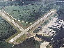
Norwood Memorial Airport covers an area of 688 acres (278 ha) and has two runways:[1]
- Runway 10/28: 3,995 x 75 ft (1,218 x 23 m), Surface: Asphalt
- Runway 17/35: 4,008 x 100 ft (1,222 x 30 m), Surface: Asphalt
For the 12-month period ending January 1, 2006, the airport had 100,000 aircraft operations, an average of 273 per day: 77% general aviation, 22% air taxi and 1% military.[1]
There are 246 aircraft based at this airport: 81% single engine, 12% multi-engine, 4% jet aircraft and 2% helicopters.[1]
The airport also includes two flight schools and Flight Level Aviation as an FBO. Charter services operate commonly out of the airport.
As a result of federal budget cuts, the air traffic control tower was to be closed in 2013, but FAA funding was restored before closure took place, enabling continued operation.[5]
Incidents
On June 4, 2007 a Mooney M-20-P crashed into the woods south of the airport while on final approach. One person was killed.[6]
In March 2010, the airport was closed due to severe flooding.[7]
References
- 1 2 3 4 5 FAA Airport Master Record for OWD (Form 5010 PDF), effective 2007-03-15
- ↑ "Codes - Airline and airport codes search". IATA. Retrieved 2012-10-22.
- ↑ "Norwood Memorial". NFDC. FAA. Retrieved 2012-10-22.

- ↑ "Massachusetts Naval Air Bases, Coast Guard Bases, Military & Auxiliary Air Fields 1923-1945". Massachusetts Aviation Historical Society. 2011. Retrieved 26 June 2014.
- ↑ Laing, Keith (10 May 2013). "FAA relents on flight tower closures; GOP declares sequester skirmish win". The Hill. Retrieved 11 November 2014.
- ↑ "Woman killed in plane crash near Norwood Airport". WBZ NewsRadio 1030. 2007-06-04.
- ↑ "DOT: Norwood Airport a flooding risk". Norwood Transcript and Bulletin. 15 March 2010. Retrieved 3 January 2011.
External links
- Norwood Memorial Airport (official site)
- Flight Level Norwood
- FAA Airport Diagram (PDF), effective December 8, 2016
- Resources for this airport:
- FAA airport information for OWD
- AirNav airport information for KOWD
- ASN accident history for OWD
- FlightAware airport information and live flight tracker
- NOAA/NWS latest weather observations
- SkyVector aeronautical chart, Terminal Procedures