Norwood, Massachusetts
| Norwood, Massachusetts | ||
|---|---|---|
| Town | ||
|
Hartshorn's Market c. 1920. Behind it are the United Church of Norwood and (faintly) St. Catherine's Church, both still standing | ||
| ||
 Location in Norfolk County in Massachusetts | ||
| Coordinates: 42°11′40″N 71°12′00″W / 42.19444°N 71.20000°WCoordinates: 42°11′40″N 71°12′00″W / 42.19444°N 71.20000°W | ||
| Country | United States | |
| State | Massachusetts | |
| County | Norfolk | |
| Settled | 1678 | |
| Incorporated | 1872 | |
| Government | ||
| • Type | Representative town meeting | |
| Area | ||
| • Total | 10.6 sq mi (27.3 km2) | |
| • Land | 10.5 sq mi (27.1 km2) | |
| • Water | 0.1 sq mi (0.2 km2) | |
| Elevation | 146 ft (45 m) | |
| Population (2010) | ||
| • Total | 30,602 | |
| • Density | 2,724.0/sq mi (1,055.4/km2) | |
| Time zone | Eastern (UTC-5) | |
| • Summer (DST) | Eastern (UTC-4) | |
| ZIP code | 02062 | |
| Area code(s) | 339 / 781 | |
| FIPS code | 25-50250 | |
| GNIS feature ID | 0619460 | |
| Website | www.norwoodma.gov | |


Norwood is a town and census-designated place in Norfolk County, Massachusetts, United States. Norwood is part of the Greater Boston area. As of the 2010 census, the population was 30,602. The town was named after Norwood, England. Norwood is on the Neponset River,[1] which runs all the way to Boston Harbor from Foxborough.
History
The Town of Norwood, officially formed in 1872, was until that time part of Dedham, known as the "mother of towns", as fourteen of the present communities of eastern Massachusetts lay within its original borders. Long used as a hunting ground by Indians, Norwood was first settled by Ezra Morse in 1678. He set up a sawmill in what is now South Norwood, the part of town to which the first concentration of families, almost all of whom were farmers, migrated over the next half-century.
During the American Revolution, there was a Minuteman company organized in the area. Its captain, Aaron Guild, on learning of the British marching on Lexington and Concord, to seize the munitions stored there, rode to join the fight and arrived in time to fire on the British at Concord Bridge and participate in the running battle that chased the Redcoats back to Boston.
Abraham Lincoln passed through the town during his pre-inaugural tour of New England.
The Oak View Mansion, located in Norwood, was built by Francis Olney Winslow. Construction began in 1868 and was completed in 1870. Oak View was the scene of almost constant socializing. Some of the most prominent figures hosted in Oak View were President and future Supreme Court Justice William Howard Taft and President Calvin Coolidge.
The town shares its name with a town in the borough of Croydon, South London, England.
Geography
Norwood is located at 43°11′9″N 71°12′5″W / 43.18583°N 71.20139°W (42.185974, -71.201661).[2]
According to the United States Census Bureau, the town has a total area of 10.6 square miles (27.3 km²), of which 10.5 square mile (27.1 km²) is land and 0.1 square mile (0.2 km²) (0.66%) is water.
Demographics
| Historical population | ||
|---|---|---|
| Year | Pop. | ±% |
| 1880 | 2,845 | — |
| 1890 | 3,733 | +31.2% |
| 1900 | 5,480 | +46.8% |
| 1910 | 8,014 | +46.2% |
| 1920 | 12,627 | +57.6% |
| 1930 | 15,049 | +19.2% |
| 1940 | 15,383 | +2.2% |
| 1950 | 16,636 | +8.1% |
| 1960 | 24,898 | +49.7% |
| 1970 | 30,815 | +23.8% |
| 1980 | 29,711 | −3.6% |
| 1990 | 28,908 | −2.7% |
| 2000 | 29,587 | +2.3% |
| 2010 | 30,602 | +3.4% |
| * = population estimate. Source: United States Census records and Population Estimates Program data.[3][4][5][6][7][8][9] | ||

As of the census[11] of 2010, there were 30,602 people. The racial makeup of the town was 80.92% White, 8.01% Black or African American, 0.09% Native American, 9.57% Asian, 0.01% Pacific Islander, 0.77% from other races, and 1.25% from two or more races. Hispanic or Latino of any race were 3.58% of the population. 27.3% were of Irish descent.
As of the census[11] of 2000, there were 28,587 people, 11,623 households, and 7,380 families residing in the town. The population density was 2,727.0 people per square mile (1,053.2/km²). There were 11,945 housing units at an average density of 1,139.5 per square mile (440.1/km²). The racial makeup of the town was 90.51% White, 2.31% Black or African American, 0.09% Native American, 5.06% Asian, 0.01% Pacific Islander, 0.77% from other races, and 1.25% from two or more races. Hispanic or Latino of any race were 1.65% of the population. 34.7% were of Irish, 14.8% Italian, 5.4% American and 5.0% English ancestry according to Census 2000.
There were 11,623 households out of which 27.2% had children under the age of 18 living with them, 50.9% were married couples living together, 9.9% had a female householder with no husband present, and 36.5% were non-families. 29.4% of all households were made up of individuals and 12.0% had someone living alone who was 65 years of age or older. The average household size was 2.41 and the average family size was 3.05.
In the town the population was spread out with 20.8% under the age of 18, 6.4% from 18 to 24, 33.2% from 25 to 44, 22.1% from 45 to 64, and 17.6% who were 65 years of age or older. The median age was 39 years. For every 100 females there were 89.7 males. For every 100 females age 18 and over, there were 86.5 males.
The median income for a household in the town was $58,421, and the median income for a family was $70,164 (these figures had risen to $66,743 and $80,292 respectively as of a 2007 estimate[12]). Males had a median income of $50,597 versus $34,312 for females. The per capita income for the town was $27,720. About 2.7% of families and 4.4% of the population were below the poverty line, including 6.5% of those under age 18 and 3.9% of those age 65 or over.
Education
The Norwood Public Schools operates seven schools, and an additional school institution, The Willett Early Childhood Center (serves preschool and kindergarten children). The public elementary schools located in Norwood include: Balch, Callahan, Cleveland, Oldham, and Prescott.
Norwood has one public middle school, the Dr. Philip O. Coakley Middle School (serving 6th through 8th graders)[13] (formerly Norwood Junior High South), where all five elementary schools combine. Norwood also has a public high school, Norwood High School (NHS),[14] (serves grades 9–12). The original Norwood High School, built in the 1920s, has been replaced by a new building,[15] which opened in 2011. The new building incorporates the iconic portico and cupola that identified the original building in its design. The school mascot: Mustangs; its colors are blue, white and gold. Sports include football, swimming, gymnastics, baseball, softball, basketball, soccer, field hockey, track and field, tennis, ice hockey, volleyball, wrestling, lacrosse, and cross-country. NHS also offers various fine arts programs which include a drama troupe, string orchestra, wind ensemble, marching band, jazz band, various choruses, and a madrigal choir. The music program has been considered to be one of the finest in the country for over forty years. In 2000, the NHS Jazz Ensemble won the national high school championship. The theater department is active and puts on several shows every year.
Built in 2005, Universal Technical Institute is the newest post-secondary education center in Norwood. It is an automotive technical school featuring the Mercedes Benz Elite MSAT and the Ford FACT specialized training programs. The campus is located at 1 Upland Road, less than a mile from the Boston Providence Pike.
Norwood is also home to a private school system offering technology-oriented programs ITT Technical Institute. ITT Tech offers career-focused degree programs available at this location.[16]
The Fine Mortuary College in Norwood includes a one-room museum featuring antique embalming tables and centuries-old wooden coffins.[17]
Business
A large cluster of automobile dealerships on Route 1 is known as the Norwood "Automile". The concept of having competing dealerships join together to publicize the "Automile" as an automobile shopping center was largely the work of Ernie Boch, famous in the Boston area for his ads urging people to "Come on down!"
University Avenue in Norwood is the site of both semiconductor company Analog Devices Inc and medical software provider MEDITECH, Medical Information Technology, Inc., actually across the border in Westwood.
Architecture
- Norwood's town square is dominated by its town hall, the Norwood Memorial Municipal Building (Town Hall). It includes a 50-bell[18][19][20][21] carillon tower housing the Walter F. Tilton Memorial Carillon, one of nine carillons in Massachusetts and the seventh-largest in the United States. On the National Register of Historic Places.
- Morrill Memorial Library (1898–99), Joseph Ladd Neal, architect.
-
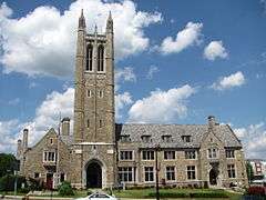
Norwood Memorial Municipal Building (Town Hall).
-

Morrill Memorial Library.
Art
Norwood was the long-time home of photographer and publisher Fred Holland Day. As a photographer, Day at one point rivalled Alfred Stieglitz in influence. The publishing firm of Copeland and Day was the American publisher of Oscar Wilde's Salome with illustrations by Aubrey Beardsley. The Day House is now a museum and the headquarters of the Norwood Historical Society. F. Holland Day Historic House Museum located at 93 Day St.
Transportation
- U.S. 1 is a major artery through Norwood. ( Runs from West Roxbury to Providence, RI.)
- Three MBTA Commuter Rail stations on the Forge Park-495 line or Franklin Line, with daily service. The stations are Norwood Depot, Norwood Central and Windsor Gardens.
- Norwood Memorial Airport
- Interstate 95
- MBTA bus route 34E[22]
Notable people
- Keith Adams, former NFL linebacker.
- Frank G. Allen, Governor of Massachusetts, 1929–1931
- Dicky Barrett, lead singer of The Mighty Mighty Bosstones[23]
- Ernie Boch, Jr., CEO, president, and spokesman of Boch Enterprises, a $1 billion business consisting primarily of automobile dealerships in Norwood, Massachusetts[24]
- Charlie Bowles, former major league baseball player[25]
- Marty Callaghan, former major league baseball player[26]
- F. Holland Day, photographer
- Allen Doyle, golf Champions Tour Star, 11-time winner on tour[27]
- Joe Dugan, former major league baseball player
- Alfred Fincher, Former pro football player for the Washington Redskins[28]
- William Cameron Forbes Governor General of the Philippines, 1909–1913
- Noah Hanifin, current NHL defenseman for the Carolina Hurricanes
- Harry and the Potters, pop rock musicians[29]
- Richie Hebner, former major league baseball player[30][31]
- Joe Hulbig, former NHL player, Boston and Edmonton[32]
- Peter Laviolette, NHL and Olympic hockey coach
- Rhoda Leonard, All-American Girls Professional Baseball League player, later a long time teacher in the Norwood Public Schools system.[33]
- Skip Lockwood, former major league baseball player[34]
- Ray Martin, former major league baseball player[35]
- Jon Purnell, United States Ambassador to Uzbekistan
- Allen Ripley, former major league baseball player[36]
- John H. Rogers, former Massachusetts House Majority Leader
- Tony Rombola, guitar player for hard rock band Godsmack[37]
- Mike Sherman, former Green Bay Packers head coach, former head coach for Texas A&M Aggies
- Tom Shillue, stand-up comedian, barbershop quartet singer and current host on Fox News Channel's overnight program, Red Eye with Tom Shillue[38]
- Mike Smith, former major league baseball player[39]
- Bill Travers, former major league baseball player[40]
References
- ↑ "Welcome to the Neponset River Watershed". Neponset.org. Retrieved 2012-07-31.
- ↑ "US Gazetteer files: 2010, 2000, and 1990". United States Census Bureau. 2011-02-12. Retrieved 2011-04-23.
- ↑ "TOTAL POPULATION (P1), 2010 Census Summary File 1, All County Subdivisions within Massachusetts". United States Census Bureau. Retrieved September 13, 2011.
- ↑ "Massachusetts by Place and County Subdivision - GCT-T1. Population Estimates". United States Census Bureau. Retrieved July 12, 2011.
- ↑ "1990 Census of Population, General Population Characteristics: Massachusetts" (PDF). US Census Bureau. December 1990. Table 76: General Characteristics of Persons, Households, and Families: 1990. 1990 CP-1-23. Retrieved July 12, 2011.
- ↑ "1980 Census of the Population, Number of Inhabitants: Massachusetts" (PDF). US Census Bureau. December 1981. Table 4. Populations of County Subdivisions: 1960 to 1980. PC80-1-A23. Retrieved July 12, 2011.
- ↑ "1950 Census of Population" (PDF). 1: Number of Inhabitants. Bureau of the Census. 1952. Section 6, Pages 21-10 and 21-11, Massachusetts Table 6. Population of Counties by Minor Civil Divisions: 1930 to 1950. Retrieved July 12, 2011.
- ↑ "1920 Census of Population" (PDF). Bureau of the Census. Number of Inhabitants, by Counties and Minor Civil Divisions. Pages 21-5 through 21-7. Massachusetts Table 2. Population of Counties by Minor Civil Divisions: 1900, 1910, and 1920. Retrieved July 12, 2011.
- ↑ "1890 Census of the Population" (PDF). Department of the Interior, Census Office. Pages 179 through 182. Massachusetts Table 5. Population of States and Territories by Minor Civil Divisions: 1880 and 1890. Retrieved July 12, 2011.
- ↑ It was suggested in 2006 that Guild's red coat must surely be historically inaccurate.Peter Schworm (2006-10-01). "He was a patriot, not a redcoat: Calls growing for new, accurate town seal". The Boston Globe. Retrieved 2006-10-06.: "Board chairman Jerry Kelleher said he, too, had noticed Guild's miscolored garment... He knew the red wasn't right." He said that "While the controversy has been 'mushrooming,' it's more a minor distraction than an embarrassing gaffe." Elisabeth McGregor , executive director of the Norwood Historical Society, said she found the flap "kind of comical", and noted the seal probably includes another mistake. 'It's April 19—would he really be plowing already?' she questioned. 'Seems pretty early.'"
- 1 2 "American FactFinder". United States Census Bureau. Retrieved 2008-01-31.
- ↑ "American FactFinder". Factfinder.census.gov. Retrieved 2012-07-31.
- ↑ Archived March 2, 2009, at the Wayback Machine.
- ↑ Archived February 4, 2009, at the Wayback Machine.
- ↑ Archived September 27, 2011, at the Wayback Machine.
- ↑ "Massachusetts School in Norwood - Boston". Itt-tech.edu. Retrieved 2012-07-31.
- ↑ Brad Kelly (2006-01-20). "DYING TO VISIT? FUNERAL INDUSTRY FASCINATION GROWS: Mortuary school in Norwood opens museum to the public". Patriot Ledger. Retrieved 2006-07-06.; college website is http://www.fine-ne.com/
- ↑ Towerbells.org database: "Traditional carillon of 50 bells...Year of latest technical information source is 2015"
- ↑ World Carillon Federation, "Bells: 50"
- ↑ Norwood Library: Norwood Historical Records, "The building’s 170-foot tower accommodates a 50 bell carillon"
- ↑ Boston Globe, South Regional edition 7/6/2013, Jean Lang: Norwood Town Hall gets a makeover: "Another concern is the carillon within the tower. There are 50 large bells that have been covered with blankets to protect them, but the blankets have to be taken on and off for the summer carillon concert series, which runs from July 1 to Aug. 19."
- ↑ MBTA bus route 34E
- ↑ http://community.myfoxboston.com/blogs/Gene_Lavanchy
- ↑ "The Automatic Life: Billionaire Ernie Boch Jr". Huffington Post. 2014-02-14.
- ↑ "Charlie Bowles Statistics and History". Baseball-Reference.com. Retrieved 2012-07-31.
- ↑ "Marty Callaghan Statistics and History". Baseball-Reference.com. Retrieved 2012-07-31.
- ↑ "Allen Doyle Official Profile". PGATOUR.com. 1948-07-26. Retrieved 2012-07-31.
- ↑ Alfred Fincher (2012-01-01). "Alfred Fincher, LB at". Nfl.com. Retrieved 2012-07-31.
- ↑ "Official Harry & the Potters site". Retrieved 2013-04-13.
- ↑ "Ultimate Mets Database - Richie Hebner". Ultimatemets.com. Retrieved 2012-07-31.
- ↑ Falla, Brian (2006), "Norwood's Natural", The Norwood Bulletin, October 5, 2006, p. 2. "Hebner's ties to Norwood remain a backbone of the story", a description of the making of a two-hour documentary on Hebner
- ↑ http://www.legendsofhockey.net:8080/LegendsOfHockey/jsp/SearchPlayer.jsp?player=10679
- ↑ Rhoda Leonard Obituary. AAGPBL official website. Retrieved on November 30, 2015.
- ↑ "Skip Lockwood Statistics and History". Baseball-Reference.com. Retrieved 2012-07-31.
- ↑ "Ray Martin Statistics and History". Baseball-Reference.com. Retrieved 2012-07-31.
- ↑ "Allen Ripley Statistics and History". Baseball-Reference.com. Retrieved 2012-07-31.
- ↑ GS Web Mistress (2012-07-27). "Home". Godsmack. Retrieved 2012-07-31.
- ↑ Tom Shillue: 5 things you didn't know about....
- ↑ "Mike Smith Statistics and History". Baseball-Reference.com. Retrieved 2012-07-31.
- ↑ "Bill Travers Statistics and History". Baseball-Reference.com. Retrieved 2012-07-31.
External links
| Wikimedia Commons has media related to Norwood, Massachusetts. |
| Wikisource has the text of a 1921 Collier's Encyclopedia article about Norwood, Massachusetts. |
- Town of Norwood
- Industrial History of Norwood, Norwood Historical Society: Historical photographs and documents
- Norwood Public Access TV, Norwood public-access television cable TV (NPA-TV) Norwood's Public-Access Station - a non-profit entity serving the Town of Norwood
- Norwood, MA - Index of Marriages and Deaths
- UTI Campuses
- The Daily News Transcript A daily newspaper that covers Norwood.
Municipalities and communities of Norfolk County, Massachusetts, United States | ||
|---|---|---|
| Cities | 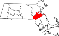 | |
| Towns | ||
| CDPs | ||
| Other village | ||