North Petherwin
| North Petherwin | |
| Cornish: Paderwynn Gledh | |
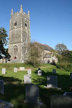 North Petherwin parish church |
|
 North Petherwin |
|
| Population | 655 (Civil Parish, 1991) |
|---|---|
| OS grid reference | SX282896 |
| Civil parish | North Petherwin |
| Unitary authority | Cornwall |
| Ceremonial county | Cornwall |
| Region | South West |
| Country | England |
| Sovereign state | United Kingdom |
| Post town | LAUNCESTON |
| Postcode district | PL15 |
| Dialling code | 01566 |
| Police | Devon and Cornwall |
| Fire | Cornwall |
| Ambulance | South Western |
| EU Parliament | South West England |
| UK Parliament | North Cornwall |
Coordinates: 50°40′52″N 4°26′02″W / 50.681°N 4.434°W
North Petherwin (Cornish: Paderwynn Gledh) is a civil parish and village in east Cornwall, England, United Kingdom. The village is situated five miles (8 km) northwest of Launceston on a ridge above the River Ottery valley.[1]
North Petherwin is a rural parish within the historic boundaries of Devon, having been transferred to Cornwall in 1966. Historically, the Dukes of Bedford have been major land owners in the parish. As well as the church town, settlements include Hellescott, Brazacott, and Maxworthy. The hamlets of Petherwin Gate and Daws are close to the village.[2]
The Tamar Otter and Wildlife Centre is North Petherwin's main tourist attraction. As well as having European and Asian Short Clawed otters it has a duck pond, a nature trail where owls can be seen, a restaurant area and a gift shop.[3]
Parish church and school
The parish church is dedicated to St Paternus (see also South Petherwin) and is unusually grand for a small village church. It was described in White's Devonshire Directory of 1850 as: ... an ancient structure, with a tower and five bells... (containing)... memorials of the Yeo and other families.[4] The north aisle is Norman and the south Perpendicular and many of the windows, including those of the clerestory, are 13th century in style. There is some old woodwork including a communion rail dated 1685.
The village has a school, North Petherwin Primary School,[5] dating back to 1878. The school is coeducational and has been expanded in recent years.
References
- ↑ Ordnance Survey: Landranger map sheet 190 Bude & Clovelly ISBN 978-0-319-23145-6
- ↑ Ordnance Survey One-inch Map of England & Wales; Bodmin and Launceston, sheet186. 1946
- ↑ Tamar Otter and Wildlife Centre website; accessed April 2010
- ↑ GENUKI website; North Petherwin; retrieved April 2010
- ↑ North Petherwin school website. Retrieved April 2010
External links
| Wikimedia Commons has media related to North Petherwin. |
Cornwall Portal | |
| Unitary authorities | |
| Major settlements |
|
| Rivers | |
| Topics | |