Bude


Coordinates: 50°49′26″N 4°32′31″W / 50.824°N 4.542°W
Bude (b-yew-d, Cornish: Porthbud[3]) is a small seaside resort town in north Cornwall, England, UK, in the civil parish of Bude-Stratton and at the mouth of the River Neet (also known locally as the River Strat). It was formerly sometimes known as Bude Haven.[4] It lies southwest of Stratton, south of Flexbury and Poughill, and north of Widemouth Bay and is located along the A3073 road off the A39. Bude is twinned with Ergué-Gabéric in Brittany, France.[5] Bude's coast faces Bude Bay in the Celtic Sea, part of the Atlantic Ocean.
Its earlier importance was as a harbour, and then a source of sea sand useful for improving the moorland soil. The Victorians favoured it as a watering place, and it was a popular seaside destination in the 20th century.
Geography
It lies just south of Flexbury and north of Widemouth Bay and is located along the A3073 road off the A39 road.
Coastline
Bude Coast SSSI (Site of Special Scientific Interest), located between Compass Cove to the south and Furzey Cove to the north, is noted for its geological and biological interest.[6] Carboniferous sandstone cliffs surround Bude. During the Variscan Orogeny the strata were heavily faulted and folded. As the sands and cliffs around Bude contain calcium carbonate (a natural fertiliser), farmers used to take sand from the beach, for spreading on their fields. The cliffs around Bude are the only ones in Cornwall that are made of Carboniferous sandstone, as most of the Cornish coast is formed of Devonian slate, granite and Precambrian metamorphic rocks.[6] The stratified cliffs of Bude give their name to a sequence of rocks called the Bude Formation. Many formations can be viewed from the South West Coast Path which passes through the town.
Many ships have been wrecked on the jagged reefs which fringe the base of the cliffs. The figurehead of one of these, the Bencoolen, a barque whose wrecking in 1862 resulted in the drowning of most of the crew, was preserved in the churchyard but was transferred to the town museum to save it from further decay.[7][8] The aftermath of the wreck of the Bencoolen was described by Robert Stephen Hawker in letters which were published in Hawker's Poetical Works (1879).[9]
Climate
Like the rest of the British Isles and South West England, Bude experiences a maritime climate with cool summers and mild winters. Temperature extremes at the Met Office weather station at Bude range from −11.1 °C (12.0 °F) during February 1969[10] to 32.2 °C (90.0 °F) in June 1976.[11] The Met Office recorded Bude as the sunniest place in the United Kingdom during the summer of 2013 with 783 hours of sunlight.[12]
| Climate data for Bude 15m asl, 1971–2000, Extremes 1960– | |||||||||||||
|---|---|---|---|---|---|---|---|---|---|---|---|---|---|
| Month | Jan | Feb | Mar | Apr | May | Jun | Jul | Aug | Sep | Oct | Nov | Dec | Year |
| Record high °C (°F) | 15.5 (59.9) |
16.7 (62.1) |
21.1 (70) |
25.3 (77.5) |
27.1 (80.8) |
32.2 (90) |
31.7 (89.1) |
31.6 (88.9) |
27.9 (82.2) |
24.0 (75.2) |
18.1 (64.6) |
17.2 (63) |
32.2 (90) |
| Average high °C (°F) | 9.0 (48.2) |
8.9 (48) |
10.2 (50.4) |
12.0 (53.6) |
15.1 (59.2) |
17.2 (63) |
19.3 (66.7) |
19.6 (67.3) |
17.7 (63.9) |
14.9 (58.8) |
11.8 (53.2) |
10.0 (50) |
13.8 (56.8) |
| Average low °C (°F) | 3.6 (38.5) |
3.3 (37.9) |
4.4 (39.9) |
4.9 (40.8) |
7.6 (45.7) |
10.4 (50.7) |
12.6 (54.7) |
12.6 (54.7) |
10.4 (50.7) |
8.6 (47.5) |
6.0 (42.8) |
4.6 (40.3) |
7.5 (45.5) |
| Record low °C (°F) | −10.6 (12.9) |
−11.1 (12) |
−7.8 (18) |
−3.8 (25.2) |
−1.7 (28.9) |
1.1 (34) |
4.2 (39.6) |
3.9 (39) |
1.4 (34.5) |
−2.5 (27.5) |
−5 (23) |
−8.9 (16) |
−10.6 (12.9) |
| Average precipitation mm (inches) | 97.6 (3.843) |
76.4 (3.008) |
68.7 (2.705) |
55.0 (2.165) |
51.6 (2.031) |
57.2 (2.252) |
54.9 (2.161) |
70.6 (2.78) |
81.0 (3.189) |
98.2 (3.866) |
105.2 (4.142) |
106.2 (4.181) |
922.6 (36.323) |
| Mean monthly sunshine hours | 60.9 | 84.2 | 116.7 | 179.7 | 212.5 | 193.3 | 190.7 | 189.4 | 157.1 | 109.4 | 73.2 | 57.3 | 1,624.3 |
| Source #1: Met Office[13] | |||||||||||||
| Source #2: Royal Dutch Meteorological Institute[14] | |||||||||||||
History and description
In the Middle Ages the only dwelling here was Efford Manor, the seat of the Arundells of Trerice, which had a chapel of St Leonard. Another chapel existed at Chapel Rock which was dedicated to Holy Trinity and St Michael.[4]
Bude Canal, which once ran to Launceston, now runs only a few miles inland. Several historic wharf buildings were demolished in the 1980s, but since then the canal has undergone restoration.[15]
Until the start of the 20th century, the neighbouring town of Stratton was dominant, and a local saying is "Stratton was a market town when Bude was just a furzy down", meaning Stratton was long established when Bude was just gorse-covered downland. (A similar saying is current at Saltash about Plymouth.)
On 10 October 1844, during an exercise, the unnamed Bude Lifeboat capsized when the steering oar broke followed by four on the port side, and two of the crew were drowned.[16]
The local senior school Budehaven Community School suffered a major fire in October 1999, destroying most of the older parts of the school. The school was forced to close for several weeks until temporary classrooms could be brought in. The damaged part of the school was rebuilt with interactive classrooms.[17]
Present-day Bude has two beaches with broad sands close to the town, and is a good centre for adjacent beaches. Its sea front faces west and the Atlantic rollers make for good surfing when conditions are right.[18] The main access road into and out of Bude is the Atlantic Highway (A39).
Stagecoach South West operates numerous bus services in and around Bude, with direct services to local towns, such as Holsworthy, Wadebridge Bideford, and Barnstaple.
Victorian resort

In the latter part of Queen Victoria's reign, the middle classes were discovering the attractions of sea bathing, and the romantic movement encouraged an appreciation of wild scenery and the Arthurian Legend. To serve this desire, a railway line was extended to Bude in 1898. This encouraged the holiday trade, but Bude never rivalled Newquay or the resorts in south Cornwall and Devon.
Beaches
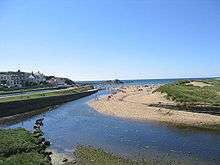
There are a number of good beaches in the Bude area, many of which offer good surfing conditions. Bude was the founder club in British Surf Life Saving.
- Summerleaze, Crooklets and 'middle' beaches are both within the town;
- Widemouth Bay is a few miles south of the town and offers a long, wide sandy beach;
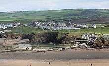
- Sandymouth Beach is owned by the National Trust, and has spectacular cliffs and rock formations with shingle below the cliffs and a large expanse of sand at low tide. There are also a number of other coves and beaches to be found and explored in the local area.
Bude Harbour and Canal
In the 18th century there was a small unprotected tidal harbour at Bude, but it was difficult whenever the sea was up. The Bude Canal Company built a canal and improved the harbour. Around twenty small boats use the tidal moorings of the original harbour during the summer months. Most are sport fishermen, but there is also some small-scale, semi-commercial, fishing for crab and lobster.
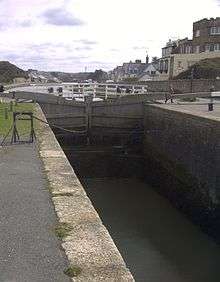
There is a wharf on the Bude Canal about half a mile from the sea lock that links the canal to the tidal haven. This can be opened only at or near high tide, and then only when sea conditions allow. North Cornwall District Council administered the canal, harbour and lock gates until its abolition in March 2009.[19] These gates were renewed after the originals were damaged in a storm in 2008. They are the only manually operated sea lock gates in England. The pier head by the locks is a Grade II listed structure.
The canal is one of the few of note in south-west England. Its original purpose was to take small tub boats of mineral-rich sand from the beaches at Bude and carry them inland for agricultural use on fields. A series of inclined planes carried the boats over 400 vertical feet (120 m) to Red Post, where the canal branched south along the upper Tamar Valley towards Launceston, east to Holsworthy and north to the Tamar Lakes, that fed the canal. The enterprise was always in financial difficulty, but it carried considerable volumes of sand and also coal from south Wales. The arrival of the railway at Holsworthy and the production of cheap manufactured fertiliser undermined the canal's commercial purpose, and it was closed down and sold to the district municipal water company. However the wharf area and harbour enjoyed longer success, and coastal sailing ships carried grain across to Wales and coal back to Cornwall.
Notable buildings

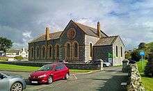
Notable buildings include the Perpendicular medieval parish church (St Olaf's) in the village of Poughill just outside Bude; the parish church of St Michael and All Angels, built in 1835 and enlarged in 1876 (the architect was George Wightwick), Ebbingford Manor,[20] and the town's oldest house, Quay Cottage in the centre of town. Bude Castle was built about 1830 for Victorian inventor Sir Goldsworthy Gurney and is now a heritage centre.[21]
At the northernmost point of Efford Down Farm, overlooking Summerleaze Beach and the breakwater, a former coastguard lookout stands. Known as Compass Point and built by the Acland family in 1840 of local sandstone, it is based on the Temple of Winds in Athens. It was moved to its current position in 1880. It is so called as it has points of the compass carved in each of its octagonal sides.[22]
Railway
From 1879 Bude's nearest railway station was at Holsworthy, ten miles away. The railway came to Bude itself in 1898.[23] The line was built by the London and South Western Railway, but was incorporated into the Southern Railway in 1923 and British Railways in 1948.
Bude railway station was served by the Atlantic Coast Express, providing a direct service to/from London (Waterloo); the "ACE" was discontinued in 1964. Bude station and the entire Bude branch line closed on 1 October 1966 as part of the Beeching Axe.
Bude and neighbouring Stratton are more distant from the rail network than any other towns in England and Wales. Barnstaple (35 miles north east), Bodmin Parkway (32 miles south) and Gunnislake (32 miles sse) are the nearest National Rail stations with regular services. Okehampton (29 miles) has occasional summer-only trains from Exeter. A "rail link" coach runs from Exeter St Davids railway station to Bude Strand via Okehampton.
Industry
Tourism is the main industry in the Bude area whilst some fishing is carried on. In the past, the staple trade was the export of sand, which, being highly charged with calcium carbonate, was much used as fertiliser. There are also golf links in the town.
The UK's top manufacturer of air rifle tuning kits, Tinbum Tuning (TbT) are based just outside of the town in the village of Marhamchurch.
The largest employer associated with Bude is GCHQ Bude, with over 250 civil servants and contractors, sited north of the town near Morwenstow.
Bude has an industrial estate which houses Bott Ltd, which manufactures racking and tool-holding accessories and storage systems for vans and workshops. It was the home of Tripos Receptor Research, which produced prototypes of drugs for the pharmaceutical industry until it ceased trading in 2008 as a result of the global economic downturn and the purpose-built building it once occupied is now empty.
Local government
Bude is in the North Cornwall parliamentary constituency which is represented by Scott Mann MP. It developed from the much older market town of Stratton, 1 1⁄8 miles inland to the east. Since Cornwall became a unitary authority in 2009 there has been a two-tier structure of local government: Cornwall Council (administers, for example, schools and highways, housing, social services, canal and harbour, refuse and recycling collection, street cleanliness); and Bude-Stratton Town Council (local children's playground, Bude "castle"). There was some local argument when the town council adopted the name Bude-Stratton, as it was previously Stratton-Bude. Bude's population in 1901 was 2308; by 2001 it had risen to 4674.[24]
Sport
The town is home to a number of sports teams including Bude RFC—the town's rugby club, and Bude Town FC—the local football club. Bude is the host town of the North Cornwall Cup, a large youth football event held every August. Bude & North Cornwall Golf Club is ideally situated within the town centre.
Notable residents
- The writer Jean Rhys (1890–1979) lived in Bude in the late 1950s and began the final version of her most successful novel, Wide Sargasso Sea, while there.[25]
- Pamela Colman Smith (1878–1951), artist, illustrator, and writer, best known for designing the Rider-Waite-Smith deck of divinatory tarot cards for Arthur Edward Waite, lived in Bude, and died here on 18 September 1951.
- Step-brothers George Mills, author of children's books, and Arthur F. H. Mills, the crime and adventure novelist, were born in Bude; their grandfather Arthur Mills, MP, lived nearby at Efford Down House.
- Stanley Lucas was a supercentenarian who served as a Bude town councillor.
- Rennie Montague Bere was a British mountaineer, naturalist and nature conservationist who lived in a nearby cottage in his retirement; among his books are The Book of Bude and Stratton and The Nature of Cornwall.
- Sir Laurence Dudley Stamp, one of the leading British geographers of the 20th century, lived in Bude in his retirement.
- American singer-songwriter Tori Amos has a home and studio here.
References
- ↑ 2011 Census most of Bude North and Stratton
- ↑ 2011 Census all of Bude South
- ↑ "List of Place-names agreed by the MAGA Signage Panel" (PDF). Cornish Language Partnership. May 2014. Retrieved 2015-01-11.
- 1 2 Cornish Church Guide (1925) Truro: Blackford; p. 66
- ↑ "Bude Is Twinned With ERGUE- GABERIC....a taster.......". Bude People. 10 May 2011. Retrieved 22 July 2012.
- 1 2 "Bude Coast" (PDF). Natural England. 1987. Archived from the original (PDF) on 24 October 2012. Retrieved 26 October 2011.
- ↑ Mee, Arthur (1937) Cornwall. (The King's England.) London: Hodder & Stoughton; p. 38
- ↑ Seal, Jeremy (2 April 2002). "Cornwall: the Shipwreck Coast". Daily Telegraph (The). Retrieved 27 March 2012.
- ↑ Hawker, R. S. (1879) The Poetical Works of Robert Stephen Hawker; [ed.] by J. G. Godwin. London: C. Kegan Paul; pp. xi-xiii
- ↑ "1969 temperature". KNMI.
- ↑ "1976 temperature". KNMI.
- ↑ "Summer of 2013". BBC News. Retrieved 7 January 2015.
- ↑ "Bude Climate". UKMO. Retrieved 2013-08-29.
- ↑ "Bude extremes". KNMI. Retrieved 12 Nov 2011.
- ↑ "Bude Canal and Harbour Society official website". bude-canal.co.uk. 2010. Retrieved 12 May 2013.
- ↑ Larn, Richard; Larn, Bridget. Wreck & Rescue round the Cornish coast. Redruth: Tor Mark Press. p. 48. ISBN 978-0-85025-406-8.
- ↑ "Bude Town Council; Class of 79". Bude-cornwall.co.uk. Archived from the original on 17 March 2012. Retrieved 22 June 2012.
- ↑ "The Atlantic Roar Ten Miles Away: Bude ... nowhere do the Atlantic waters rise so high; we were told that the roar of the sea can be heard ten miles away. It has magnificent seas in a gale and glorious sunsets any time ...", in: Mee, Arthur (1937) Cornwall. (The King's England.) London: Hodder & Stoughton; p. 37
- ↑ "North Cornwall District Council". Ncdc.gov.uk. Archived from the original on 17 July 2012. Retrieved 22 June 2012.
- ↑ Pevsner, N. (1970) Cornwall; 2nd ed. Penguin; pp. 47 (the house is mainly mid 18th century though there was a manor house here in the 14th century)
- ↑ "Bude Castle". British Listed Buildings Online. Retrieved 8 May 2011.
- ↑ "Efford Down Stables, Camping, and Business Park , Bude, Cornwall, UK". Efforddown.co.uk. Retrieved 22 June 2012.
- ↑ David J Wroe (1988). The Bude Branch. ISBN 978-0-946184-43-9.
- ↑ ncdc.gov.uk Archived 28 April 2004 at the Wayback Machine.
- ↑ Paravisini-Gebert, Lizabeth (1998). "Jean Rhys and Phyllis Shand Allfrey: The Story of a Friendship" (PDF). The Jean Rhys Review. 9 (1-2): 9. Retrieved 12 May 2013.
Further reading
- Rennie Montague Bere; Bryan Dudley Stamp (1980). The Book of Bude and Stratton. ISBN 978-0-86023-055-7.
External links
| Wikimedia Commons has media related to Bude, Cornwall. |
| Wikisource has the text of the 1911 Encyclopædia Britannica article Bude. |
- Bude at DMOZ
- Cornwall Record Office Online Catalogue for Bude
- British Pathé News footage of Surf Guard training at Crooklets Beach in 1961
- Bott Ltd
Cornwall Portal | |
| Unitary authorities | |
| Major settlements |
|
| Rivers | |
| Topics | |