New Hampshire Route 111
| |||||||
|---|---|---|---|---|---|---|---|
|
Map of southern New Hampshire with NH 111 highlighted in red | |||||||
| Route information | |||||||
| Maintained by NHDOT | |||||||
| Length: | 50.027 mi[1] (80.511 km) | ||||||
| Major junctions | |||||||
| West end: |
| ||||||
| East end: |
| ||||||
| Location | |||||||
| Counties: | Hillsborough, Rockingham | ||||||
| Highway system | |||||||
| |||||||

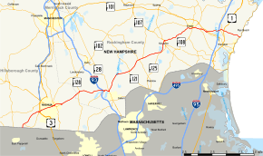
New Hampshire Route 111 (abbreviated NH 111) is a 50.027-mile-long (80.511 km) east–west highway in Hillsborough and Rockingham counties in southeastern New Hampshire. The road runs from the Massachusetts border at Hollis to North Hampton on the Atlantic shore.
The western terminus of NH 111 is at the Massachusetts state line in Hollis, where, as Massachusetts Route 111 (Nashua Road), the road continues into the town of Pepperell, Massachusetts. The eastern terminus of NH 111 is at the junction with Ocean Boulevard (New Hampshire Route 1A) in North Hampton. At its terminus, the road is known as Atlantic Avenue.
History

The portion of NH 111 between New Hampshire Route 27 in Hampton and NH 1A in Hampton Beach was once designated New Hampshire Route 101D.[2]
Major intersections
| County | Location[1][3] | mi[1][3] | km | Destinations | Notes |
|---|---|---|---|---|---|
| Hillsborough | Hollis | 0.000 | 0.000 | Continuation from Massachusetts | |
| 0.828 | 1.333 | Western terminus of NH 111A (western segment) | |||
| Nashua | 4.554– 4.731 | 7.329– 7.614 | Exit 5 on Everett Turnpike Eastern terminus of NH 111A (western segment) | ||
| Hudson | 7.734 | 12.447 | Southern terminus of NH 102 | ||
| Rockingham | Windham | 13.187 | 21.222 | ||
| 17.356– 17.940 | 27.932– 28.872 | Exit 3 on I-93 | |||
| 18.018 | 28.997 | Eastern terminus of NH 111A (middle segment) | |||
| 18.804 | 30.262 | ||||
| Hampstead | 24.374 | 39.226 | |||
| 27.070 | 43.565 | ||||
| Danville | 27.970 | 45.013 | Western terminus of NH 111A (eastern segment) | ||
| Kingston | 31.448 | 50.611 | Western end concurrency with NH 125 | ||
| 33.169 | 53.380 | Western end of concurrency with NH 107 | |||
| 34.212 | 55.059 | Eastern end of concurrency with NH 107 / NH 125 | |||
| Exeter | 40.528 | 65.223 | Western end of concurrency with NH 108 | ||
| 40.612 | 65.359 | Western end of concurrency with NH 27 Eastern terminus of NH 111A (eastern segment) | |||
| 40.843 | 65.730 | Eastern end of concurrency with NH 108 | |||
| 41.999 | 67.591 | Western end of wrong-way concurrency with NH 88 | |||
| 42.089 | 67.736 | Eastern end of wrong-way concurrency with NH 88 | |||
| 43.292 | 69.672 | Eastern end of concurrency with NH 27 | |||
| 43.457– 43.627 | 69.937– 70.211 | Exit 12 on NH 101 | |||
| North Hampton | 45.977 | 73.993 | |||
| 46.721 | 75.190 | ||||
| 50.027 | 80.511 | Eastern terminus | |||
1.000 mi = 1.609 km; 1.000 km = 0.621 mi
| |||||
Suffixed routes
New Hampshire Route 111A
New Hampshire Route 111A is a designation held by three separate state highways in New Hampshire. Although none of the segments directly connect, all three roadways are linked by their parent, New Hampshire Route 111.
Western segment
| |
|---|---|
| Location: | Hollis–Nashua |
| Length: | 4.935 mi[1] (7.942 km) |
The western segment of NH 111A is a 4.935-mile-long (7.942 km) east–west loop road in Hollis and Nashua in Hillsborough County.
The eastern terminus is in Nashua at NH 111, west of the point where NH 111 and U.S. Route 3 meet. At that location, NH 111A is known as Main Dunstable Road. The western terminus is at NH 111 approximately 0.8 miles (1.3 km) north of the Massachusetts state line in Hollis. At that location, NH 111A is called South Depot Road.
Middle segment
| |
|---|---|
| Location: | Pelham–Windham |
| Length: | 9.173 mi[1] (14.763 km) |
The middle segment of NH 111A is a 9.173-mile-long (14.763 km) northeast–southwest highway between Pelham in Hillsborough County and Windham in Rockingham County. It is signed as an east–west highway.
The southern, officially western, terminus is in the town of Pelham at New Hampshire Route 128 (Mammoth Road) approximately 0.5 miles (0.80 km) north of the Massachusetts state line. At this point, the road is named Marsh Road. The northern, signed eastern, terminus of the highway is in the town of Windham at NH 111 between Cobbetts Pond and Canobie Lake. At this point, the road is known as Range Road.
Eastern segment
| |
|---|---|
| Location: | Danville–Exeter |
| Length: | 15.024 mi[1] (24.179 km) |
The eastern segment of NH 111A is a 15.024-mile-long (24.179 km) southwest–northeast highway between Danville and Exeter in Rockingham County. It is signed as an east–west highway.
The eastern terminus of this segment of NH 111A is in Exeter at NH 111 on the west side of String Bridge. At this location, NH 111A is named Water Street. The western terminus is in Danville at NH 111. At that location, the road is known as Main Street.
References
- 1 2 3 4 5 6 Bureau of Planning & Community Assistance (February 20, 2015). "NH Public Roads". Concord, New Hampshire: New Hampshire Department of Transportation. Retrieved April 7, 2015.
- ↑ New Hampshire Routes 101-125
- 1 2 Bureau of Planning & Community Assistance (April 3, 2015). "Nodal Reference 2015, State of New Hampshire". New Hampshire Department of Transportation. Retrieved April 7, 2015.
- Town of Hollis, Hillsborough County
- City of Nashua, Hillsborough County
- Town of Hudson, Hillsborough County
- Town of Windham, Rockingham County
- Town of Hampstead, Rockingham County
- Town of Danville, Rockingham County
- Town of Kingston, Rockingham County
- Town of Exeter, Rockingham County
- Town of North Hampton, Rockingham County