New Hampshire Route 112
| ||||
|---|---|---|---|---|
|
Kancamagus Highway (N. Woodstock - Conway) | ||||
|
Map of northern New Hampshire with NH 112 highlighted in red | ||||
| Route information | ||||
| Maintained by NHDOT | ||||
| Length: | 56.387 mi[1] (90.746 km) | |||
| Tourist routes: |
| |||
| Major junctions | ||||
| West end: |
| |||
| ||||
| East end: |
| |||
| Location | ||||
| Counties: | Grafton, Carroll | |||
| Highway system | ||||
| ||||

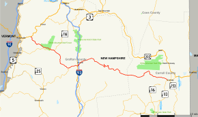
New Hampshire Route 112 (abbreviated NH 112) is a 56.39-mile-long (90.75 km) east–west state highway in northern New Hampshire. The highway winds across the state, connecting Bath to Conway through the heart of the scenic and mountainous White Mountain National Forest.
The eastern portion of NH 112 is known as the Kancamagus Highway, running 32 miles (51 km) through the White Mountains from Lincoln to Conway.[2] 26.5 miles (42.6 km) of the highway have been designated a National Scenic Byway by the United States Department of Transportation under the name "Kancamagus Scenic Byway". The highway is known for its views of autumn foliage and is a popular drive in September and October for leaf peeping tourism.
The Kancamagus Highway stays open all winter, although it occasionally closes for short periods while crews clear heavy snows. Its only major intersection, Bear Notch Road, which connects with the town of Bartlett, is closed all winter.[3]
Much of the western portion of NH 112 is also in the White Mountain National Forest, passing through Kinsman Notch with the Lost River tourist attraction. The section between NH 116 and North Woodstock is called Lost River Road.[4]
Route description
Bath to Lincoln
NH 112 begins in the town of Bath at US 302 and NH 10 approximately 4 miles (6 km) east of the Vermont border. The highway runs southeast along the Wild Ammonoosuc River, then climbs through Kinsman Notch. NH 112 crosses into the town limits of Woodstock and descends along the Lost River, meeting the northern terminus of NH 118 before continuing east to the village of North Woodstock. The route passes through the center of the village, crossing US 3 and interchanging with I-93 before entering Lincoln. NH 112 passes through downtown Lincoln as Main Street.

Lincoln to Conway (Kancamagus Highway)
The Kancamagus Highway portion of NH 112 begins just east of the town center. The state highway reenters the White Mountain National Forest, following the East Branch of the Pemigewasset River for approximately 4 miles (6 km), then the Hancock Branch for another 8 miles (13 km), steadily ascending as it progresses eastward. Following a series of hairpin turns, NH 112 crosses the height of land at 2,855-foot (870 m) Kancamagus Pass and begins to descend along the Swift River in the Saco River watershed, which it does for its remaining 21 miles (34 km). Eventually the highway leaves the National Forest and enters the town of Conway, where it terminates at Main Street (NH 16 / NH 113) west of downtown.
The Kancamagus Highway is a very popular tourist destination due to its many scenic views and locations. Two scenic outlook sites are located along the Kancamagus Highway, including one from near the crest of Kancamagus Pass. There are six National Forest campground sites, along with numerous hiking trails.
History

The Kancamagus Highway opened in 1959 after two dead-end stretches of road were linked, creating a connection between I-93 in Lincoln and NH 16 in Conway. Locally known as "The Kanc", the road was paved in 1964, and in 1968 it was plowed for the first time.
The highway is named after Kancamagus (pronounced "Kank-ah-MAW-gus",[5] "The Fearless One"[6]), third and final sagamore of the Penacook Confederacy of Native American tribes. Nephew of Wonalancet and grandson of Passaconaway,[7] Kancamagus ruled what is now southern New Hampshire. Wearied of fighting English settlers, he made the decision in 1691 to move north into upper New Hampshire and what is now Quebec, Canada.
Following Hurricane Irene in August 2011, two sections of NH 112 were closed, pending repair work and evaluation of damage. The Kancamagus Highway was closed from the Sabbaday Falls picnic area across Kancamagus Pass to the Discovery Trail parking area in the eastern part of Lincoln. A section of the western portion of NH 112 along the Wild Ammonoosuc River was closed; as of September 6, 2011, a single lane of the western section had been reopened.[8] As of late June 2012, the highway had been completely reopened, though some stretches were in the process of being repaved.
Major intersections
| County | Location[1][9] | mi[1][9] | km | Destinations | Notes |
|---|---|---|---|---|---|
| Grafton | Bath | 0.000 | 0.000 | Western terminus | |
| Easton | 8.664 | 13.943 | Western end of concurrency with NH 116 | ||
| 9.546 | 15.363 | Eastern end of concurrency with NH 116 | |||
| Woodstock | 17.906 | 28.817 | Northern terminus of NH 118 | ||
| 20.471 | 32.945 | Village of North Woodstock | |||
| 20.824– 21.172 | 33.513– 34.073 | Exit 32 on I-93 | |||
| Carroll | Conway | 56.387 | 90.746 | Eastern terminus | |
1.000 mi = 1.609 km; 1.000 km = 0.621 mi
| |||||
Scenery along the highway
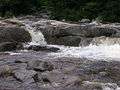 Lower Falls on the Swift River
 Rocky Gorge on the Swift River
 Covered Bridge in Albany, New Hampshire
References
- 1 2 3 Bureau of Planning & Community Assistance (February 20, 2015). "NH Public Roads". Concord, New Hampshire: New Hampshire Department of Transportation. Retrieved April 7, 2015.
- ↑ "Kancamagus Scenic Byway". USFHA America's Byways program. Retrieved March 23, 2015.
- ↑ Kancamagus Highway Closures
- ↑ Town of Woodstock official website: Interactive Mapping
- ↑ Lewis, Bea (9 August 2009). "How to say Kancamagus". Fosters.com. Retrieved 18 July 2014.
- ↑ Bowen, Arabella; Obolsky, Todd; Velton, Ross (2003). The Rough Guide to New England. Rough Guides. p. 501. Retrieved 18 July 2014.
- ↑ http://www.sidis.net/PASSChap4.htm
- ↑ "511 Info". NH Department of Transportation. Retrieved September 6, 2011.
- 1 2 Bureau of Planning & Community Assistance (April 3, 2015). "Nodal Reference 2015, State of New Hampshire". New Hampshire Department of Transportation. Retrieved April 7, 2015.
External links
| Wikimedia Commons has media related to New Hampshire Route 112. |
- Kancamagus Scenic Byway
- kancamagushighway.com, unofficial website