Nevada State Route 208
| ||||
|---|---|---|---|---|
| Topaz/Yerington Road | ||||
|
Nevada State Route 208, highlighted in red | ||||
| Route information | ||||
| Maintained by NDOT | ||||
| Length: | 37.892 mi[1] (60.981 km) | |||
| Existed: | 1976 – present | |||
| Major junctions | ||||
| West end: |
| |||
| East end: |
| |||
| Highway system | ||||
| ||||

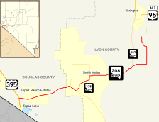
State Route 208 (SR 208) is a state highway within the counties of Douglas and Lyon in Nevada, United States. It connects U.S. Route 395 (US 395) north of Topaz Lake to Alternate U.S. Route 95 in Yerington. The road serves as the primary transportation corridor of Smith Valley and is Main street in Yerington. The route was originally a portion of State Route 3.
Route description
_in_Lyon_County%2C_Nevada_near_sunset.jpg)

The character of the highway gradually changes descending from the foothills of the Sierra Nevada into high desert, finally reaching the agricultural communities of Smith and Mason Valleys. The highway begins at a junction with US 395 in the foothills of the Sierra Nevada, at the junction with Nevada highway 208, at the hamlet of Holbrook Junction.[2] The highway descends out of the Sierra into Smith Valley. Once reaching the valley the road joins the route of the West Walker River, which the highway follows from this point on. The highway departs Smith Valley via the river, using Wilson Canyon to connect with Mason Valley,[2] another agricultural valley in the otherwise arid deserts of Nevada.
Inside Mason Valley the road forks, with route 208 serving the east side of the valley and route 339 serving the west. Shortly after the split is where the West and East Walker Rivers merge to form the Walker River. Both roads lead to Yerington, straddling each side of the river. In Yerington, Route 208 serves as Main Street. The route terminates at the north end of Yerington where traffic defaults onto southbound U.S. Route 95 Alternate.[2]
History
This is one of the oldest highways in Nevada. The route was first part of the lesser used Sonora Pass branch of the California Trail.[2] The route appeared as a highway on maps since at least as far back as 1919. The highway was first numbered as a portion of State Route 3, a designation in use by 1929. The State Route 3 designation extended from Reno to the California state line in Fish Lake Valley west of Lida. This route is drivable today as U.S. Route 395 Alternate, State Route 529 and U.S. Route 395 to the modern terminus of Route 208. It extended past Yerington via what is now U.S. Route 95 Alternate, U.S. Route 95 and SR 266.[3]
During the late 1970s and early 1980s the state of Nevada renumbered most state routes. The 1978 edition of the Nevada Highways map was the first to use both the 3 and 208 designations, with the 1982 edition the first to use only the 208 designation.[4]
Major intersections
- Note: Mileposts in Nevada reset at county lines; the start and end mileposts for each county are given in the county column.
| County | Location | mi[1] | km | Destinations | Notes |
|---|---|---|---|---|---|
| Douglas 0.00–8.77 | Holbrook Junction | 0.00 | 0.00 | ||
| Lyon 0.00–29.01 | | 1 | 1.6 | ||
| Wellington | 2 | 3.2 | |||
| Smith | |||||
| | |||||
| | |||||
| Yerington | |||||
| 29.01 | 46.69 | ||||
| 1.000 mi = 1.609 km; 1.000 km = 0.621 mi | |||||
See also
 Nevada portal
 U.S. Roads portal
References
| Wikimedia Commons has media related to Nevada State Route 208. |
- 1 2 "State Maintained Highways of Nevada: Descriptions and Maps - Quarter 2 Update". Nevada Department of Transportation. July 2011. Retrieved 3 Oct 2011.
- 1 2 3 4 Nevada Road and Recreation Atlas (Map). 1:250000. Benchmark Maps. 2003. pp. 54–55,62–63. ISBN 0-929591-81-X.
- ↑ 1929 Highway Map of the State of Nevada (PDF) (Map). Nevada Department of Transportation. 1929. Retrieved 2008-11-17.
- ↑ "Historical Maps". Nevada Department of Transportation. Retrieved March 26, 2015.