Nevada State Route 207
| ||||
|---|---|---|---|---|
| Kingsbury Grade | ||||
|
Nevada State Route 207, highlighted in red | ||||
| Route information | ||||
| Maintained by NDOT | ||||
| Length: | 11.092 mi[1] (17.851 km) | |||
| Existed: | 1976 – present | |||
| Major junctions | ||||
| West end: |
| |||
| East end: |
| |||
| Highway system | ||||
| ||||

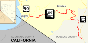
State Route 207 (SR 207) is a state highway in Douglas County, Nevada. Commonly known as the Kingsbury Grade, it is one of three Nevada highways that connects the western edge of the state to the Lake Tahoe region through the Carson Range. The route was part of State Route 19 prior to 1976.
Route description
_in_Stateline%2C_Nevada.jpg)
State Route 207 begins at a junction with U.S. Route 50 in Stateline, less than 1 mile (1.6 km) from the California state line near the southern shores of Lake Tahoe. From there, the route heads eastward on an uphill climb through the Kingsbury area to travel through Daggett Pass (elevation 7,344 feet (2,238 m)).[2]
_just_to_the_north.jpg)
After exiting the pass, SR 207 continues its trek eastward through Toiyabe National Forest lands. It goes through several switchbacks, eventually turning southward as it descends the mountains. The road goes down an escarpment to the Carson Valley floor. SR 207 comes to an end at its junction with Foothill Road (SR 206), at the site of Mottsville west of Gardnerville.[1][3]
History
A road connecting Lake Tahoe to the Carson Valley, situated in the approximate location of today's SR 207, appears on Nevada state maps as early as 1919.[4] By 1929, this unimproved road was included in the state highway system as the northwestern end of State Route 19, a longer route stretching from Lake Tahoe through Minden and south to the California state line near Holbrook.[5] This section of State Route 19 was 13 miles (21 km) long,[6] about 9 miles (14 km) of which comprised the Kingsbury Grade portion of highway.[7] SR 19 through the mountains remained unimproved for many years; the route was not paved until 1967.[8] By 1968, the eastern end of the Kingsbury Grade was moved southwards to line up with what is now Mottsville Lane, mirroring the approximately 11 miles (18 km) alignment of the present highway.[9]
Following the realignment, the Kingsbury Grade section of SR 19 was not altered until the 1976 renumbering of Nevada's state highway system on July 1, 1976. In that process, this portion of SR 19 was assigned to the new State Route 207.[10] This change was first seen on state highway maps in 1978.[11] Also included in the new State Route 207 was the 3-mile (4.8 km) section of Mottsville Lane which connects Kingsbury Grade to State Route 88, making SR 207 about 14 miles (23 km) long; however, this section appears to have been removed from the route by 1983.[12] The route has been largely unchanged since.
Major intersections
The entire route is in Douglas County.
| Location | mi[1] | km | Destinations | Notes | |
|---|---|---|---|---|---|
| Stateline | 0.000 | 0.000 | |||
| Mottsville | 11.092 | 17.851 | |||
| Mottsville Lane – Minden, Gardnerville | Continuation beyond SR 206 | ||||
| 1.000 mi = 1.609 km; 1.000 km = 0.621 mi | |||||
See also
 Nevada portal
 U.S. Roads portal
References
| Wikimedia Commons has media related to Nevada State Route 207. |
- 1 2 3 "State Maintained Highways of Nevada: Descriptions and Maps - Quarter 1 Update". Nevada Department of Transportation. April 2011. Retrieved 29 May 2011.
- ↑ Kingsbury and Zephyr Cove Area (PDF) (Map). Nevada Department of Transportation. 2007. Retrieved 30 May 2011.
- ↑ Quadrangle 7-12 (PDF) (Map). Nevada Department of Transportation. 1997. Retrieved 30 May 2011.
- ↑ Road Map of the State of Nevada (Map). Nevada Department of Highways. 1919. Retrieved 3 June 2011.
- ↑ Highway Map – State of Nevada (Map). Nevada Department of Highways. 1929. Retrieved 3 June 2011.
- ↑ Official Road Map of the State of Nevada (Map). Nevada Department of Highways. 1936. Retrieved 3 June 2011.
- ↑ Official Road Map of the State of Nevada (Map). Nevada Department of Highways. 1941. Retrieved 3 June 2011.
- ↑ 1967 Official Highway Map of Nevada (Map). Nevada Department of Highways. 1967. § E1. Retrieved 3 June 2011.
- ↑ 1968 Official Highway Map of Nevada (Map). Nevada Department of Highways. 1968. Lake Tahoe Region inset. Retrieved 3 June 2011.
- ↑ Nevada's State Maintained Highways: Descriptions, Index and Maps. Nevada Department of Transportation. 2001. p. 101.
- ↑ Official Highway Map of Nevada (Map) (1978-1979 ed.). Nevada Department of Highways. 1978. Lake Tahoe Region inset. Retrieved 3 June 2011.
- ↑ Official Highway Map of Nevada (Map) (1983-1984 ed.). Nevada Department of Transportation. 1983. Lake Tahoe Region inset. Retrieved 3 June 2011.