Neff's Mill Covered Bridge
| Neff's Mill Covered Bridge | |
|---|---|
 | |
| Coordinates | 39°58′44″N 76°13′33″W / 39.9788°N 76.2258°WCoordinates: 39°58′44″N 76°13′33″W / 39.9788°N 76.2258°W |
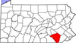
| Locale | Lancaster County, Pennsylvania, United States |
| Official name | Pequea #7 Bridge |
| Characteristics | |
| Design | single span, double Burr arch truss |
| Total length | 102 feet (31.1 m) |
| History | |
| Constructed by |
Built by Christian Brackbill Rebuilt by James C. Carpenter |
| Construction begin | 1824, rebuilt in 1875 |
 | |
 | |
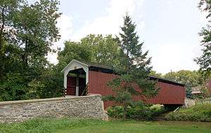
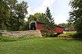
The Neff's Mill Covered Bridge or Bowman's Mill Covered Bridge is a covered bridge that spans the Pequea Creek on the border between West Lampeter Township and Strasburg Township in Lancaster County, Pennsylvania, United States.[1] A county-owned and maintained bridge, its official designation is the Pequea #7 Bridge.[2]
The bridge has a single span, wooden, double Burr arch trusses design with the addition of steel hanger rods. The deck is made from oak planks.[2] It is painted red, the traditional color of Lancaster County covered bridges, on both the inside and outside. Both approaches to the bridge are painted in the traditional white color. It is purportedly the narrowest covered bridge in the county.[3][4]
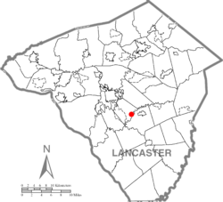
The bridge's WGCB Number is 38-36-22. Added in 1980, it is listed on the National Register of Historic Places as structure number 80003538.[5] It is located at 39°58′43.8″N 76°13′33″W / 39.978833°N 76.22583°W (39.97883, -76.22583), on Penn Grant Road 1.25 miles to the east of U.S. Route 222 and to the south of Lampeter, Pennsylvania and Pennsylvania Route 741.[6]
History
The covered bridge was originally built by Christian Brackbill in 1824 for an unknown cost. It was known as Bowman's Mill Covered Bridge. It was rebuilt in 1875 by James C. Carpenter at a cost of $1,860.[1][3]
Dimensions
- Length: 90 feet (27.4 m) span and 102 feet (31 m) total lengthNote:[7]
- Width: 11 feet 7 inches (3.53 m) clear deck and 15 feet (4.6 m) total widthNote:[7]
- Overhead clearance: 11 feet (3.4 m)Note:[7]
- Underclearance: 13 feet 6 inches (4.11 m)
Gallery
 A wide view of the side of the bridge
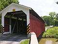 A three-quarters view of the bridge
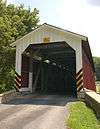 One of the bridge's portals
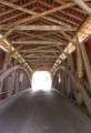 The inside of the bridge
 Closeup of the Burr arch truss design
 The window and painted sign inside the bridge
See also
References
- 1 2 Bickel, Hank (2005-06-23). "Neff Mill Bridge". Covered Bridges of the Northeast USA. Retrieved 2006-08-04.
- 1 2 "Neff's Mill Covered Bridge". Lancaster County, PA Government Portal. County of Lancaster, Pennsylvania. 2001-10-20. Retrieved 2006-07-07.
- 1 2 "Neff's Mill Covered Bridge". Lancaster County Pennsylvania Dutch Country Official Visitors Center. Pennsylvania Dutch Convention & Visitors Bureau. 2006. Retrieved 2006-07-07.
- ↑ McCain, Dr. Roger A. "Neff's Mill Bridge". A Guide to Old Covered Bridges of Southeastern Pennsylvania and nearby areas. Retrieved 2006-08-03.
- ↑ "PENNSYLVANIA - Lancaster County". National Register of Historic Places. Retrieved 2007-03-20.
- ↑ Travis, Dale. "38-36-22". Round Barns & Covered Bridges. Retrieved 2006-08-08.
- 1 2 3 Note: The dimensions of this bridge are not agreed on by multiple sources. The total length is published as either 102 or 103 feet, the clear deck width as 11 feet and 11 feet 7 inches. It is also unlikely that the bridge is actually 15 feet wide, given the limited clear deck width. The sign posted on the bridge indicates an overhead clearance of 11 feet, but the government source lists it as 11 feet, 6 inches.
| Wikimedia Commons has media related to Neff's Mill Covered Bridge. |
| Topics |   | |
|---|---|---|
| Lists by county |
| |
| Lists by city | ||
| Other lists | ||
| ||