Forkland, Alabama
| Forkland, Alabama | |
|---|---|
| Town | |
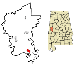 Location in Greene County and the state of Alabama | |
| Coordinates: 32°38′51″N 87°52′2″W / 32.64750°N 87.86722°W | |
| Country | United States |
| State | Alabama |
| County | Greene |
| Area | |
| • Total | 3.51 sq mi (9.08 km2) |
| • Land | 3.49 sq mi (9.05 km2) |
| • Water | 0.01 sq mi (0.03 km2) |
| Elevation | 151 ft (46 m) |
| Population (2010) | |
| • Total | 649 |
| • Density | 186/sq mi (71.7/km2) |
| Time zone | Central (CST) (UTC-6) |
| • Summer (DST) | CDT (UTC-5) |
| ZIP code | 36740 |
| Area code(s) | 334 |
| FIPS code | 01-27376 |
| GNIS feature ID | 0118505 |
Forkland is a town in Greene County, Alabama, United States. At the 2010 census the population was 649.[1] It was incorporated around 1974.[2]
History
Forkland has one site on the National Register of Historic Places, St. John's-In-The-Prairie, and two sites nearby, Rosemount and Thornhill.
Geography
Forkland is located in southern Greene County at 32°38′52″N 87°52′2″W / 32.64778°N 87.86722°W (32.647702, -87.867236),[3] between the Black Warrior River 4 miles (6 km) to the east and the Tombigbee River 2 miles (3 km) to the west. The Black Warrior joins the Tombigbee 9 miles (14 km) to the south of Forkland, just north of Demopolis. U.S. Route 43 passes through Forkland, leading north 14 miles (23 km) to Eutaw, the county seat, and south 10 miles (16 km) to Demopolis.
According to the U.S. Census Bureau, Forkland has a total area of 3.5 square miles (9.1 km2), of which 0.01 square miles (0.03 km2), or 0.32%, is water.[1]
Demographics
| Historical population | |||
|---|---|---|---|
| Census | Pop. | %± | |
| 1880 | 205 | — | |
| 1970 | 304 | — | |
| 1980 | 429 | 41.1% | |
| 1990 | 667 | 55.5% | |
| 2000 | 629 | −5.7% | |
| 2010 | 649 | 3.2% | |
| Est. 2015 | 601 | [4] | −7.4% |
| U.S. Decennial Census[5] 2013 Estimate[6] | |||
As of the census[7] of 2000, there were 629 people, 245 households, and 161 families residing in the town. The population density was 180.2 people per square mile (69.6/km²). There were 309 housing units at an average density of 88.5 per square mile (34.2/km²). The racial makeup of the town was 10.65% White, 89.19% Black or African American, and 0.16% from two or more races.
There were 245 households out of which 36.3% had children under the age of 18 living with them, 35.5% were married couples living together, 27.8% had a female householder with no husband present, and 33.9% were non-families. 32.7% of all households were made up of individuals and 10.6% had someone living alone who was 65 years of age or older. The average household size was 2.57 and the average family size was 3.32.
In the town the population was spread out with 31.8% under the age of 18, 6.8% from 18 to 24, 26.1% from 25 to 44, 24.5% from 45 to 64, and 10.8% who were 65 years of age or older. The median age was 34 years. For every 100 females there were 88.3 males. For every 100 females age 18 and over, there were 77.3 males.
The median income for a household in the town was $18,698, and the median income for a family was $22,115. Males had a median income of $24,375 versus $16,544 for females. The per capita income for the town was $9,314. About 29.5% of families and 31.5% of the population were below the poverty line, including 38.2% of those under age 18 and 31.0% of those age 65 or over.
Notable people
- Maxie Baughan, former NFL player
- Charlotte Durante, first African American female city commissioner in Delray Beach, Florida
- Bobo Jenkins, born in Forkland, electric blues guitarist and songwriter, who later owned his own recording studio and record label in Detroit
Annual festivals
- Bama Bike Fest, motorcycle riders' national and international festival
Gallery
Below are photographs taken in Forkland as part of the Historic American Buildings Survey:
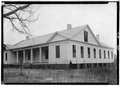 Perrin-Willis House
_-_Virginia_Glover_House%2C_County_Roads_19_and_4%2C_Forkland%2C_Greene_County%2C_AL_HABS_ALA%2C32-FORK%2C5-1.tif.jpg) Virginia Glover House
Virginia Glover House_SOUTH_SIDE_-_The_Tavern%2C_County_Road_19%2C_Forkland%2C_Greene_County%2C_AL_HABS_ALA%2C32-FORK%2C4-1.tif.jpg) The Tavern
The Tavern Old slave house at Strawberry Hill Plantation
_AND_WEST_SIDE_-_Levy-Glover_Store%2C_County_Roads_19_and_4%2C_Forkland%2C_Greene_County%2C_AL_HABS_ALA%2C32-FORK%2C6-1.tif.jpg) Levy-Glover Store
Levy-Glover Store_-_Methodist_Parsonage%2C_County_Road_4%2C_Forkland%2C_Greene_County%2C_AL_HABS_ALA%2C32-FORK%2C3-1.tif.jpg) Methodist parsonage
Methodist parsonage_-_H._B._Brewer_House%2C_County_Road_4%2C_Forkland%2C_Greene_County%2C_AL_HABS_ALA%2C32-FORK%2C7-2.tif.jpg) H. B. Brewer House
H. B. Brewer House
External links
References
- 1 2 "Geographic Identifiers: 2010 Demographic Profile Data (G001): Forkland town, Alabama". U.S. Census Bureau, American Factfinder. Retrieved October 28, 2016.
- ↑ https://news.google.com/newspapers?nid=1817&dat=19741231&id=B3g0AAAAIBAJ&sjid=Ep0EAAAAIBAJ&pg=6667,7241932&hl=en
- ↑ "US Gazetteer files: 2010, 2000, and 1990". United States Census Bureau. 2011-02-12. Retrieved 2011-04-23.
- ↑ "Annual Estimates of the Resident Population for Incorporated Places: April 1, 2010 to July 1, 2015". Retrieved July 2, 2016.
- ↑ "U.S. Decennial Census". Census.gov. Retrieved June 6, 2013.
- ↑ "Annual Estimates of the Resident Population: April 1, 2010 to July 1, 2013". Retrieved June 3, 2014.
- ↑ "American FactFinder". United States Census Bureau. Retrieved 2008-01-31.
Coordinates: 32°38′52″N 87°52′02″W / 32.647702°N 87.867236°W
Municipalities and communities of Greene County, Alabama, United States | ||
|---|---|---|
| Cities | 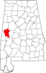 | |
| Towns | ||
| Unincorporated communities | ||