National Register of Historic Places listings in Grady County, Oklahoma
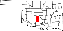
Location of Grady County in Oklahoma
This is a list of the National Register of Historic Places listings in Grady County, Oklahoma.
This is intended to be a complete list of the properties and districts on the National Register of Historic Places in Grady County, Oklahoma, United States. The locations of National Register properties and districts for which the latitude and longitude coordinates are included below, may be seen in a map.[1]
There are 13 properties and districts listed on the National Register in the county.
- This National Park Service list is complete through NPS recent listings posted December 2, 2016.[2]
- Adair
- Alfalfa
- Atoka
- Beaver
- Beckham
- Blaine
- Bryan
- Caddo
- Canadian
- Carter
- Cherokee
- Choctaw
- Cimarron
- Cleveland
- Coal
- Comanche
- Cotton
- Craig
- Creek
- Custer
- Delaware
- Dewey
- Ellis
- Garfield
- Garvin
- Grady
- Grant
- Greer
- Harmon
- Harper
- Haskell
- Hughes
- Jackson
- Jefferson
- Johnston
- Kay
- Kingfisher
- Kiowa
- Latimer
- Le Flore
- Lincoln
- Logan
- Love
- Major
- Marshall
- Mayes
- McClain
- McCurtain
- McIntosh
- Murray
- Muskogee
- Noble
- Nowata
- Okfuskee
- Oklahoma
- Okmulgee
- Osage
- Ottawa
- Pawnee
- Payne
- Pittsburg
- Pontotoc
- Pottawatomie
- Pushmataha
- Roger Mills
- Rogers
- Seminole
- Sequoyah
- Stephens
- Texas
- Tillman
- Tulsa
- Wagoner
- Washington
- Washita
- Woods
- Woodward
Current listings
| [3] | Name on the Register[4] | Image | Date listed[5] | Location | City or town | Description |
|---|---|---|---|---|---|---|
| 1 | Chickasha Downtown Historic District | 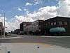 |
(#05000132) |
Roughly bounded by 1st St., 3rd St., Kansas Ave., 7th St., and the alley north of Chickasa Ave. 35°03′04″N 97°56′14″W / 35.051111°N 97.937222°W |
Chickasha | |
| 2 | Grady County Courthouse | 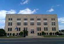 |
(#05000131) |
326 W. Choctaw Ave. 35°03′09″N 97°56′07″W / 35.0525°N 97.935278°W |
Chickasha | |
| 3 | Griffin House | 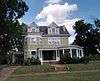 |
(#14000297) |
1402 W. Kansas Ave. 35°03′01″N 97°57′03″W / 35.050191°N 97.950738°W |
Chickasha | |
| 4 | Jewett Site | Upload image | (#79001995) |
Address Restricted |
Bradley | |
| 5 | Knippelmeir Farmstead | 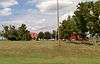 |
(#11000638) |
672 OK 152 35°20′07″N 97°59′41″W / 35.335278°N 97.994722°W |
Minco vicinity | |
| 6 | Minco Armory | 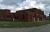 |
(#94000484) |
407 W. Pontotoc St. 35°18′56″N 97°56′46″W / 35.315556°N 97.946111°W |
Minco | |
| 7 | New Hope Baptist Church | 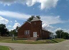 |
(#03000515) |
1202 S. Shepherd St. 35°02′20″N 97°55′51″W / 35.038889°N 97.930833°W |
Chickasha | |
| 8 | Oklahoma College for Women Historic District | 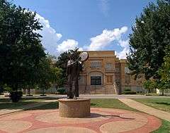 |
(#01000950) |
roughly bounded by Grand Ave., 19th St., Alabama Ave., and the alley west of 15th St. 35°01′51″N 97°57′17″W / 35.030833°N 97.954722°W |
Chickasha | |
| 9 | Pocasset Gymnasium | 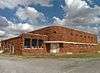 |
(#96001489) |
0.5 miles south of junction of Dutton Rd. and U.S. Highway 81 35°11′31″N 97°57′17″W / 35.191944°N 97.954722°W |
Pocasset | |
| 10 | Rock Island Depot |  |
(#85000699) |
Chickasha Ave. 35°03′07″N 97°55′55″W / 35.051944°N 97.931944°W |
Chickasha | |
| 11 | Silver City Cemetery | Upload image | (#08001149) |
6/10 mile from the section line on the southern side of section 22, T10N, R6W I.M. 35°19′42″N 97°44′54″W / 35.328333°N 97.748333°W |
Tuttle | |
| 12 | US Post Office and Federal Courthouse | 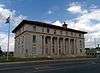 |
(#94001509) |
Southwestern corner of the junction of 4th and Choctaw Sts. 35°03′07″N 97°56′12″W / 35.051944°N 97.936667°W |
Chickasha | |
| 13 | Verden Separate School | 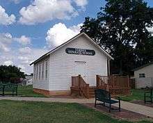 |
(#05001416) |
315 E. Ada Sipuel Ave. 35°02′39″N 97°55′43″W / 35.044167°N 97.928611°W |
Chickasha |
See also
| Wikimedia Commons has media related to National Register of Historic Places in Grady County, Oklahoma. |
- List of National Historic Landmarks in Oklahoma
- National Register of Historic Places listings in Oklahoma
References
- ↑ The latitude and longitude information provided in this table was derived originally from the National Register Information System, which has been found to be fairly accurate for about 99% of listings. For about 1% of NRIS original coordinates, experience has shown that one or both coordinates are typos or otherwise extremely far off; some corrections may have been made. A more subtle problem causes many locations to be off by up to 150 yards, depending on location in the country: most NRIS coordinates were derived from tracing out latitude and longitudes off of USGS topographical quadrant maps created under the North American Datum of 1927, which differs from the current, highly accurate WGS84 GPS system used by most on-line maps. Chicago is about right, but NRIS longitudes in Washington are higher by about 4.5 seconds, and are lower by about 2.0 seconds in Maine. Latitudes differ by about 1.0 second in Florida. Some locations in this table may have been corrected to current GPS standards.
- ↑ "National Register of Historic Places: Weekly List Actions". National Park Service, United States Department of the Interior. Retrieved on December 2, 2016.
- ↑ Numbers represent an ordering by significant words. Various colorings, defined here, differentiate National Historic Landmarks and historic districts from other NRHP buildings, structures, sites or objects.
- ↑ National Park Service (2009-03-13). "National Register Information System". National Register of Historic Places. National Park Service.
- ↑ The eight-digit number below each date is the number assigned to each location in the National Register Information System database, which can be viewed by clicking the number.
| Topics | |
|---|---|
| Lists by states |
|
| Lists by insular areas | |
| Lists by associated states | |
| Other areas | |
| |
Municipalities and communities of Grady County, Oklahoma, United States | ||
|---|---|---|
| Cities | | |
| Towns | ||
| Unincorporated communities |
| |
| Ghost towns | ||
| Footnotes | ‡This populated place also has portions in an adjacent county or counties | |
This article is issued from Wikipedia - version of the 7/12/2016. The text is available under the Creative Commons Attribution/Share Alike but additional terms may apply for the media files.