Mount Kilcoy, Queensland
| Mount Kilcoy Queensland | |||||||||||||
|---|---|---|---|---|---|---|---|---|---|---|---|---|---|
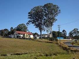 Mount Kilcoy State School, 2015 | |||||||||||||
 Mount Kilcoy | |||||||||||||
| Coordinates | 26°51′S 152°35′E / 26.850°S 152.583°ECoordinates: 26°51′S 152°35′E / 26.850°S 152.583°E | ||||||||||||
| Population | 255 (2011)[1] | ||||||||||||
| Postcode(s) | 4515 | ||||||||||||
| LGA(s) | Somerset Region | ||||||||||||
| State electorate(s) | Nanango | ||||||||||||
| Federal Division(s) | Blair | ||||||||||||
| |||||||||||||
Mount Kilcoy is a locality in the Somerset Region, Queensland, Australia. At the 2011 Australian Census the locality recorded a population of 255.[1]
Mount Kilcoy occupies a valley drained by Kilcoy Creek at the southern end of the Conondale Range. Kilcoy Weir was built at Mount Kilcoy and is able to retain a maximum of 158 megalitres.[2] The more flatter land along the creek is used for agriculture while the sloping terrain towards the north, east and western boundaries remains vegetated.
Mount Kilcoy State School opened in 1909 with a single teacher.[3]
References
- 1 2 Australian Bureau of Statistics (31 October 2012). "Mount Kilcoy (State Suburb)". 2011 Census QuickStats. Retrieved 18 August 2015.
- ↑ "Weirs". Seqwater. Retrieved 18 August 2015.
- ↑ "Mount Kilcoy State School". Department of Education and Training. Retrieved 18 August 2015.
External links
![]() Media related to Mount Kilcoy, Queensland at Wikimedia Commons
Media related to Mount Kilcoy, Queensland at Wikimedia Commons
This article is issued from Wikipedia - version of the 8/17/2015. The text is available under the Creative Commons Attribution/Share Alike but additional terms may apply for the media files.