Crossdale, Queensland
| Crossdale Queensland | |||||||||||||
|---|---|---|---|---|---|---|---|---|---|---|---|---|---|
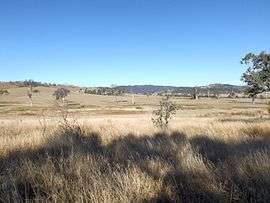 Paddocks along Wivenhoe Somerset Dam Road, 2015 | |||||||||||||
 Crossdale | |||||||||||||
| Coordinates | 27°10′54″S 152°33′04″E / 27.18167°S 152.55111°ECoordinates: 27°10′54″S 152°33′04″E / 27.18167°S 152.55111°E | ||||||||||||
| Population | 190 (2011)[1] | ||||||||||||
| Postcode(s) | 4312 | ||||||||||||
| LGA(s) | Somerset Region | ||||||||||||
| State electorate(s) | Nanango | ||||||||||||
| Federal Division(s) | Blair | ||||||||||||
| |||||||||||||
Crossdale is a rural locality in the Somerset Region, Queensland, Australia.[2] In the 2011 census, Crossdale had a population of 190 people.[1]
Geography

The vegetated slopes of Little Mount Brisbane (left of image)
Part of the western boundary of Crossdale follows the Stanley River. Some of the waters of Somerset Dam are within the locality. Crossdale is relatively large and has a diverse topography. In the north east the elevations rises along the north of the D'Aguilar Range. Little Mount Brisbane is located close to the Somerset Dam wall. In the south another hilly area reaches heights greater than 300 m around McKey Hill. A majority of the locality is devoid of vegetation although the slopes remain covered by bushland.[3]
References
- 1 2 Australian Bureau of Statistics (31 October 2012). "Crossdale". 2011 Census QuickStats. Retrieved 11 April 2014.
- ↑ "Crossdale (entry 44861)". Queensland Place Names. Queensland Government. Retrieved 11 April 2014.
- ↑ "Queensland Globe". State of Queensland. Retrieved 24 August 2015.
This article is issued from Wikipedia - version of the 8/25/2015. The text is available under the Creative Commons Attribution/Share Alike but additional terms may apply for the media files.