Atkinsons Dam, Queensland
| Atkinsons Dam Queensland | |||||||||||||
|---|---|---|---|---|---|---|---|---|---|---|---|---|---|
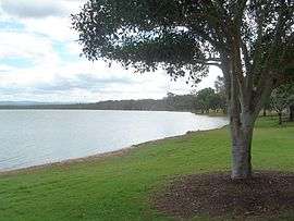 The shores of Lake Atkinson, 2011 | |||||||||||||
 Atkinsons Dam | |||||||||||||
| Coordinates | 27°25′54″S 152°27′03″E / 27.43167°S 152.45083°ECoordinates: 27°25′54″S 152°27′03″E / 27.43167°S 152.45083°E | ||||||||||||
| Population | 193 (2011)[1] | ||||||||||||
| Postcode(s) | 4311 | ||||||||||||
| Location | |||||||||||||
| LGA(s) | Somerset Region | ||||||||||||
| State electorate(s) | Nanango | ||||||||||||
| Federal Division(s) | Blair | ||||||||||||
| |||||||||||||
Atkinsons Dam is a rural locality in the Somerset Region, Queensland, Australia.[2] It is known for the Atkinson Dam which occupies most of the locality. In the 2011 census, Atkinson Dam had a population of 193 people.[1]
The northern boundary of the locality is marked by Buaraba Creek, a tributary of Lockyer Creek.
History
Atkinson's Lagooon Provisional School opened on 6 August 1885. On 1 January 1909, it was upgraded to a State School. It closed in 1968.[3][4][5]
References
- 1 2 Australian Bureau of Statistics (31 October 2012). "Atkinsons Dam (SSC)". 2011 Census QuickStats. Retrieved 7 June 2014.
- ↑ "Atkinsons Dam (entry 44832)". Queensland Place Names. Queensland Government. Retrieved 7 June 2014.
- ↑ Queensland Family History Society (2010), Queensland schools past and present (Version 1.01 ed.), Queensland Family History Society, ISBN 978-1-921171-26-0
- ↑ "Opening and closing dates of Queensland Schools". Queensland Government. Retrieved 7 June 2014.
- ↑ "Agency ID6409, Atkinson's Lagoon State School". Queensland State Archives. Retrieved 9 June 2014.
External links
![]() Media related to Atkinson Dam at Wikimedia Commons
Media related to Atkinson Dam at Wikimedia Commons
This article is issued from Wikipedia - version of the 7/1/2015. The text is available under the Creative Commons Attribution/Share Alike but additional terms may apply for the media files.