Mill Creek Historic District (Bryn Mawr and Gladwyne, Pennsylvania)
|
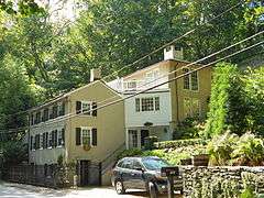
Mill Creek Historic District | |
 | |
 | |
| Location | Near Bryn Mawr and Gladwyne, Pennsylvania |
|---|---|
| Coordinates | 40°1′32″N 75°17′8″W / 40.02556°N 75.28556°WCoordinates: 40°1′32″N 75°17′8″W / 40.02556°N 75.28556°W |
| Built | 1690, 1894 |
| Architect |
Walter K. Durham, Edmund B. Gilchrist, et al. |
| Architectural style |
Georgian, Federal, Tudor Revival, Colonial |
| NRHP Reference # | 80003575, 96000965[1] |
| Added to NRHP |
December 10, 1980 August 30, 1996 (increase) |
The Mill Creek Historic District near Bryn Mawr and Gladwyne, Pennsylvania is a historic district that was listed on the National Register of Historic Places on December 10, 1980.[1] The area of the historic district was increased on August 30, 1996.[1][2][3]
The area is roughly bounded by the Schuylkill River, Mill Cr., Righter's Mill, Rose Glen, and Monk's Rds.[1]
See also
- National Register of Historic Places listings in Montgomery County, Pennsylvania
- Cedar Crest (Gladwyne, Pennsylvania)
References
- 1 2 3 4 National Park Service (2009-03-13). "National Register Information System". National Register of Historic Places. National Park Service.
- ↑ "Mill Creek Historic District" (PDF). National Register of Historic Places, Nomination and Inventory. Pennsylvania Historical and Museum Commission. undated, after 1979. Retrieved December 30, 2013. Check date values in:
|date=(help) - ↑ Wise, Robert J. (1995). "Mill Creek Historic District (Boundary Increase)" (PDF). National Register of Historic Places Nomination Form. Pennsylvania Historical and Museum Commission. Retrieved December 30, 2013.
| Topics |   | |
|---|---|---|
| Lists by county |
| |
| Lists by city | ||
| Other lists | ||
| ||
This article is issued from Wikipedia - version of the 11/28/2016. The text is available under the Creative Commons Attribution/Share Alike but additional terms may apply for the media files.