Milan, Georgia
| Milan, Georgia | |
|---|---|
| City | |
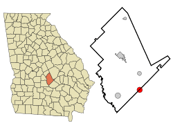 Location in Dodge County and the state of Georgia | |
| Coordinates: 32°1′13″N 83°3′51″W / 32.02028°N 83.06417°WCoordinates: 32°1′13″N 83°3′51″W / 32.02028°N 83.06417°W | |
| Country | United States |
| State | Georgia |
| Counties | Telfair, Dodge |
| Area | |
| • Total | 3.2 sq mi (8.2 km2) |
| • Land | 3.1 sq mi (8.1 km2) |
| • Water | 0.04 sq mi (0.1 km2) |
| Elevation | 312 ft (95 m) |
| Population (2010) | |
| • Total | 700 |
| • Density | 225/sq mi (86.8/km2) |
| Time zone | Eastern (EST) (UTC-5) |
| • Summer (DST) | EDT (UTC-4) |
| ZIP code | 31060 |
| Area code(s) | 229 |
| FIPS code | 13-51408[1] |
| GNIS feature ID | 0318146[2] |
Milan (/ˈmaɪlən/ MY-lən) is a city in Dodge and Telfair counties in the U.S. state of Georgia. The population was 700 at the 2010 census,[3] down from 1,012 at the 2000 census.
Geography
Milan is located in southeastern Dodge County and northwestern Telfair County at 32°1′13″N 83°3′51″W / 32.02028°N 83.06417°W (32.020195, -83.064091).[4] The county boundary passes through the center of the city. U.S. Route 280 passes through the city just south of the center, leading east 10 miles (16 km) to McRae and west 15 miles (24 km) to Abbeville.
According to the United States Census Bureau, the town has a total area of 3.2 square miles (8.2 km2), of which 3.1 square miles (8.1 km2) is land and 0.04 square miles (0.1 km2), or 1.26%, is water.[3]

Demographics
| Historical population | |||
|---|---|---|---|
| Census | Pop. | %± | |
| 1910 | 287 | — | |
| 1920 | 593 | 106.6% | |
| 1930 | 630 | 6.2% | |
| 1940 | 748 | 18.7% | |
| 1950 | 750 | 0.3% | |
| 1960 | 786 | 4.8% | |
| 1970 | 1,084 | 37.9% | |
| 1980 | 1,115 | 2.9% | |
| 1990 | 1,056 | −5.3% | |
| 2000 | 1,012 | −4.2% | |
| 2010 | 700 | −30.8% | |
| Est. 2015 | 766 | [5] | 9.4% |
As of the census[1] of 2000, there were 1,012 people, 326 households, and 215 families residing in the town. The population density was 322.6 people per square mile (124.4/km²). There were 383 housing units at an average density of 122.1 per square mile (47.1/km²). The racial makeup of the town was 64.72% White, 34.88% African American, and 0.40% from two or more races. Hispanic or Latino of any race were 1.28% of the population.
There were 326 households out of which 28.8% had children under the age of 18 living with them, 52.5% were married couples living together, 10.7% had a female householder with no husband present, and 34.0% were non-families. 32.2% of all households were made up of individuals and 18.7% had someone living alone who was 65 years of age or older. The average household size was 2.34 and the average family size was 2.97.
In the town the population was spread out with 18.2% under the age of 18, 14.9% from 18 to 24, 32.1% from 25 to 44, 21.6% from 45 to 64, and 13.1% who were 65 years of age or older. The median age was 36 years. For every 100 females there were 154.9 males. For every 100 females age 18 and over, there were 166.2 males.
The median income for a household in the town was $25,461, and the median income for a family was $33,438. Males had a median income of $28,750 versus $18,750 for females. The per capita income for the town was $12,451. About 19.8% of families and 22.8% of the population were below the poverty line, including 29.7% of those under age 18 and 28.8% of those age 65 or over.
Notable residents
- Wayne Cooper, former NBA basketball player, born in Milan
References
- 1 2 "American FactFinder". United States Census Bureau. Retrieved 2008-01-31.
- ↑ "US Board on Geographic Names". United States Geological Survey. 2007-10-25. Retrieved 2008-01-31.
- 1 2 "Geographic Identifiers: 2010 Demographic Profile Data (G001): Milan city, Georgia". U.S. Census Bureau, American Factfinder. Retrieved October 22, 2015.
- ↑ "US Gazetteer files: 2010, 2000, and 1990". United States Census Bureau. 2011-02-12. Retrieved 2011-04-23.
- ↑ "Annual Estimates of the Resident Population for Incorporated Places: April 1, 2010 to July 1, 2015". Retrieved July 2, 2016.
- ↑ "Census of Population and Housing". Census.gov. Retrieved June 4, 2015.
Municipalities and communities of Dodge County, Georgia, United States | ||
|---|---|---|
| City | 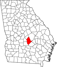 | |
| Towns | ||
| CDP | ||
| Unincorporated community | ||
| Footnotes | ‡This populated place also has portions in an adjacent county or counties | |
Municipalities and communities of Telfair County, Georgia, United States | ||
|---|---|---|
| Cities | 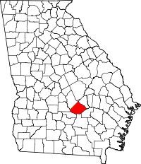 | |
| Town | ||
| Footnotes | ‡This populated place also has portions in an adjacent county or counties | |